The Richmond Oil Boom – In Search of the Steveston Gusher

In these days of environmental concerns, global climate change and pipeline protests, the oil and gas industry has become the target of much criticism. This was not the case around the turn of the last century when, in the middle of the Texas Oil Boom, attention was focused on a small fishing village at the mouth of the Fraser River.

The existence of natural gas on Lulu Island had been known for millennia.  The Musqueam fishing camp at Terra Nova was named sp`’elekw`eks (pronounced SPALL-uk-wicks), “Bubbling Water” in English, referring to the gas which was visible bubbling through the water in the slough. The Musqueam village at Garry Point was known as kw’áýò7xw’ (pronounced KWAY-ah-wh), meaning “Boiling (bubbling, churning) Water” in English, referring to the gas bubbling in the Steveston Slough.

Early European settlers in Steveston were also very aware of the gas deposits beneath Lulu Island. In 1891 the Steveston Enterprise Newspaper reported that the natural gas “forces its way through the water that accumulates in the wells and ditches where it is exposed and blackens the soil with heat when it is consumed.” Tossing a match into the bubbles would cause them to ” flash like powder”. Tipping a barrel over a gas vent would collect it and produce a continuous flame at a hole in the top of the barrel.

Steveston in 1891 looking North up 2nd Avenue. The sign on the left advertises the land auction of June 16. City of Richmond Archives photograph 1984 17 75 .


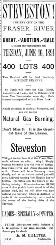
This ad from June 1891 in the Victoria Colonist invites investment in Steveston where you will “see the natural gas burning.”


Word of the gas spread with advertising for land auctions in the area. An ad in the Victoria Colonist invited people to bid on 400 lots available in Steveston, “The Key City on the Fraser River”.  According to the ad, participants would see the natural gas burning, its presence sure to make the area a manufacturing centre and a leading city in the Province.

The presence of the colourless, odorless gas led to efforts to exploit this resource. In August 1891 the Steveston Natural Gas and Development Company was formed by a group of local entrepreneurs who attempted to start a well but found their expertise and capital were not up to the task.

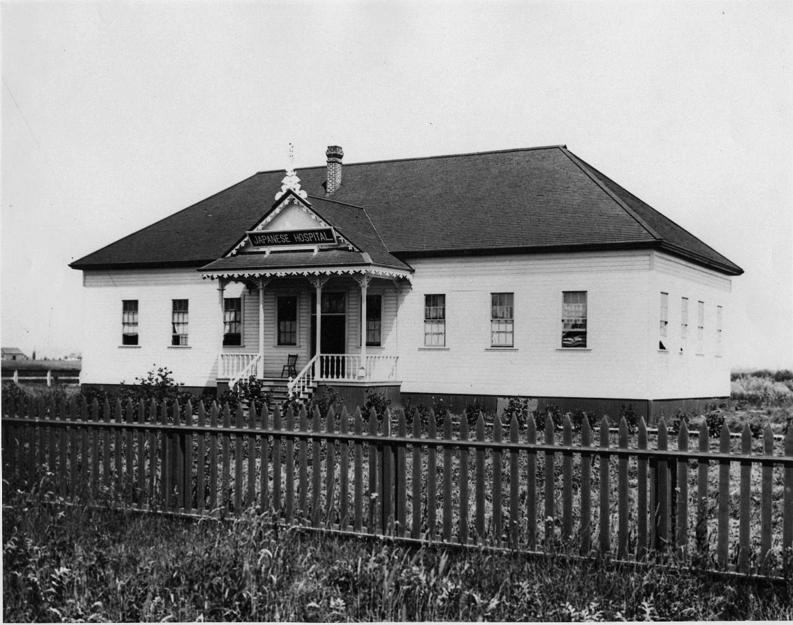
The evidence of natural gas led to the speculation that large oil or coal deposits would also be found in the area. In 1904 an organization of Vancouver businessmen, The Steveston Land and Oil Company Limited, bought a lot on No.1 Road in Steveston, east of the end of Broadway Street and next to the Japanese Hospital. They hired some experienced oil riggers and engineers from the oilfields at Beaumont, Texas. A derrick was erected and drilling began at British Columbia’s first officially recorded well. The results were encouraging and by April the shaft had reached 1000 feet, passing through “shale, clay, and blue, greasy mud or gumbo”.

In June, The optimism spurred the company to look for more investors and ads were placed in newspapers announcing that 30,000 shares were available in the company. Hoping to attract sales, the company offered early buyers a “buy two, get one free” deal.


An ad from the Victoria Colonist, June 1904, inviting investors to buy stock in the Steveston Land and Oil Company.

A copy of a share certificate for the Steveston Land and Oil Company. City of Richmond Archives photograph RCF 47.

In August the excitement grew when a large pocket of natural gas was reached by the drillers. The pressure sent sediment and water spouting high over Steveston. That evening a burn off flare was ignited to expend the gas and the resulting flame was 80 feet tall and 18 feet wide and could be seen from New Westminster. Reports claimed that the drillers expected to hit high quality oil soon, after which Steveston would take her place among the world’s great oil fields.

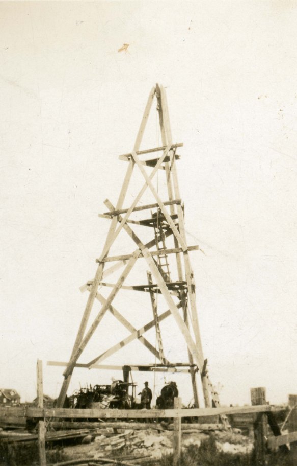
The drilling rig of the Steveston Land and Oil Company in 1904, B.C.’s first documented oil well. Sections of well piping can be seen leaning against the structure. Investors had high hopes that Steveston would be sprouting with derricks like this and black gold would be flowing from deposits under Lulu Island. City of Richmond Archives photograph    1978 15 10.

Despite all the optimism surrounding the search for oil, problems were arising. Oil was certainly present under Lulu Island, droplets had even shown up at the well, but the silt surrounding it was so flour-like that even with fine screens the piping would plug immediately. More expensive equipment and more specialized screens were shipped to the well but eventually the costs of operation overwhelmed the company and the project was abandoned in 1906.

Looking north up No.1 Road in 1908 gives a view of the back of the Steveston rail station, a Roman Catholic Church and the now defunct drilling rig of the Steveston Land and Oil Company, City of Richmond Archives photograph 1978 5 7.

The halt of operations, while saving Steveston from the fate of becoming surrounded by oil wells and a busy tanker port, did not entirely stop the idea that natural gas might be a viable product. In 1930 a well was drilled on the farm of Henry Fentiman at 120 Garry Street. Mr. Fentiman’s house was located at the north side of the present Steveston Community Park, not too far from the location of the old oil rig.

Henry Fentiman’s turn of the century mansion on his Steveston farm. City of Richmond Archives photograph 1986 54 1.

The International Pipe Line Company invested $17,000 in a plan to supply Vancouver with superior, odorless natural gas from Lulu Island, supplanting the manufactured gas used in the city at the time. The first test well was drilled to a depth of 850 feet, produced a flow of gas, but soon plugged with sand. A second well, drilled in 1931 to a depth of 730 feet and using finer screens to separate the sand, proved to be more successful and produced a steady flow of gas.

Drilling for gas on the Fentiman farm. City of Richmond Archives photograph  1978 36 22.

Once again the plan to capitalize on the energy resources of Lulu Island did not come to fruition, but Mr. Fentiman used the gas from the well for decades, easily heating his big, drafty turn of the century house, running his water heater and stove using the apparently unlimited supply of gas from his property. The only complication encountered with the system was the fluctuation in gas pressure caused by changing tides, the gas having to force its way through the whole depth of water in the well.

Henry Fentiman’s gas well, shown here in the 1930s, kept his house heated, water hot and kitchen cooking for decades. City of Richmond Archives photograph    1978 36 21.

In 1969 with the gas well now capped off, the Fentiman property was expropriated for $70,000 by City Council. The buildings were demolished in the late 1970s. The farm was sub-divided and exchanged or used for other purposes, the northern part now home to the Steveston Buddhist Temple, the Lions Club Senior Citizen housing occupies a portion of the old property and the southern part, where the Fentiman house and gas well were located were absorbed into Steveston Park. The natural gas and oil deposits that created so much excitement in the early 20th Century are still there, captured in the earth below Lulu Island but are unlikely to be looked for again.

The Fentiman house and outbuildings in the late 1970s. The gas well was located in the small building between the house and the barn. City of Richmond Archives photograph 1986 54 8.

Shady Island – Man-Made by Nature

One of the best loved features of the Steveston waterfront, Steveston Island, known as Shady Island to locals, is something rare in an urban landscape, an untouched, undeveloped piece of natural land. Home to rare species of plants and many types of birds, the island was little more than a sandbar as far back as the 1920s. Rivers are natural island builders and the Fraser would have formed the island on its own but the process was accelerated by the interference of man, leading to the treed sanctuary we see today.

2004 40 1

In this image of the Steveston Waterfront from 1889 no island protects the waterfront. City of Richmond Archives, photograph # 2004 40 1.

In Steveston’s early days, a naturally formed sandbar protected the waterfront by diverting some of the river’s water away from shore. A natural, protected channel formed behind the bar, suitable for the moorage of fishing boats and the construction of canneries.

001

A 1921 map based on a Dept. of Mines geographical survey shows the natural shape of Steveston/Shady Island at the time. A small, permanently dry island near the end of No.2 Road existed, along with a couple of small bars that showed at low tide. A submerged bar extended as far as No.1 Road. City of Richmond Archives, Reference Files.

As European immigration increased, swelling New Westminster’s population and increasing the size and amount of traffic on the river, it was necessary to keep the main river channel navigable by regular dredging. Spoils from dredging were dumped on the Steveston bar forming two distinct parts which were exposed at low tide and were connected by the submerged part of the bar. At high tide, smaller boats could still be taken across that part of the bar, although the route became closed after further dredging and natural build-up closed the gap.

002

By 1947 the addition of wing dams and dredging spoils have begun the process of building the island we know today. City of Richmond Archives, Reference Files.

In the 1930s two wing dams were built on the south side of the island to keep sand from being washed back into the channel. Later, a long training wall was built just upstream. The effect of the wing dams and training wall were to divert the river’s water toward the main channel, increasing its rate of flow and helping to keep the channel clear. This also increased the rate of natural silt build-up on the island. The island now had an important function other than a place to deposit dredging spoils. It formed a well protected harbour along the Steveston waterfront.

1977 1 14

The island before the installation of the rock dam or the breakwater. The western end of the island is still little more than a sandbar. City of Richmond Archives, photograph # 1977 1 14.

In order to to prevent the infill of the harbour channel and to provide access to the island for potential moorage facilities, a high rock dam was built across the upstream entrance to the channel. While the dam was effective, it eliminated flow through the channel, allowing effluent from the canneries to settle, creating a foul smelling basin that infiltrated the whole area with the stench of rotting fish. Within two years the top part of the dam was removed, allowing the channel to flush with each high tide.

1977 1 15

The rock breakwater can be seen in this image, shortly after its completion, ca. 1953. Also visible are the wing dams and the rock dam at the east end of the channel. City of Richmond Archives, photograph # 1977 1 15.

The island’s form was further changed when a long rock breakwater was built. It extends along the length of the island like a spine and gives it the geographical profile it has today.

1988 10 136

This image looking west over Steveston Island, ca. 1976, shows the two wing dams on the left, the training wall at bottom and the rock dam at the entrance to the channel. The photo shows how water can flow through the channel at high tide, flushing clean water through while preventing silt from entering. The end of the rock breakwater, now mostly buried, can be seen extending past the western tip of the island. City of Richmond Archives, photograph # 1988 10 136.

Steveston Island today is a gem on the waterfront of the village. Having resisted development proposals that have arisen over the years, it remains undomesticated and accessible only at low tide across the rock dam, a fact that many people learn each year when they lose track of time and are stranded by the incoming tide. As other parts of Steveston and Richmond change under the pressure of development, let’s hope this little piece of man made nature remains the same.

Dr. R. W. Large – Medical Missionary in Steveston

The Japanese Methodist Mission was established in Steveston in 1896 to serve the needs of the Japanese fishermen of the area, offering spiritual and moral guidance as well as providing medical assistance when needed. A small building was erected on the property of the Phoenix Cannery to house the mission.

2012 3 8

The Methodist Japanese Mission in Steveston, ca. 1898, with several early missionaries posing on the stairs. Rev. Thomas Crosby is at top right, (with beard), Dr. R.W. Large directly in front of him. (City of Richmond Archives photograph 2012 3 8)


Almost as soon as it was ready, an outbreak of typhoid fever made it necessary to use the building as a hospital. The hospital operated for two years with the help of volunteer Japanese nurses.

2012 3 3

The Methodist Japanese Mission set up as a hospital ward. (City of Richmond Archives photograph 2012 3 3)

In 1898 the Canadian Methodist Church hired Dr. Richard Whitfield Large ( 1874 – 1920 ) to work at the mission during the fishing season.

2012 3 1

Rev. R.W. Large, MD. (City of Richmond Archives photograph 2012 3 1)

Dr. Large was the son of a Methodist Minister in Ontario and graduated from Trinity Medical College in Toronto.  The photographs shown in this post were taken during his two seasons in Steveston and offer a view into the primitive conditions encountered by doctors serving the small communities on the coast of British Columbia. They were donated to the Archives by a member of his family.

2012 3 6

Dr. and Mrs. Large in the Doctor’s office in Steveston. (City of Richmond Archives photograph 2012 3 6)

Dr. Large married Bella Geddes in 1899 and she assisted him during that season in Steveston. The next year he was appointed to take charge of the Mission in Bella Bella and worked there until 1910 when he transferred to the Mission Hospital in Port Simpson. The R.W. Large Memorial Hospital in Bella Bella was named in his memory after his death in 1920.

2012 3 7

Dr. Large performs the first operation in Steveston. Mrs. Large assists as the anaesthetist. (City of Richmond Archives photograph 2012 3 7)

In 1900, the Japanese Fisherman’s Hospital took over the medical needs of the Japanese community in Steveston and operated until 1942 when the internment of Japanese-Canadians took place.

1978 14 10

The Steveston Japanese Hospital took over the medical needs of the Japanese community starting in 1900. Image ca. 1920. (City of Richmond Archives photograph 1978 14 10)

Vantage Point – Industry on the South Arm of the Fraser

Steveston Harbour showing canneries and fish boats, 1959. City of Richmond Archives Photograph 2010 87 29

Steveston Harbour showing canneries and fish boats, 1959. City of Richmond Archives Photograph 2010 87 29

A recent addition to the holdings of the City of Richmond Archives is an album of aerial photographs taken from 1959 to 1962 showing industry on the South Arm of the Fraser River, at New Westminster, and on the Upper Fraser.

The album was created by the New Westminster Harbour Commission with aerial photographs taken by George Allen.

Crown Zellerbach paper mill and wharf, 1959. City of Richmond Archives Photograph 2010 87 28

Crown Zellerbach paper mill and wharf, 1959. City of Richmond Archives Photograph 2010 87 28

Images from 1959 depict Steveston Harbour and the wharves of what were Richmond’s three major industrial plants on the South Arm: Crown Zellerbach Paper Mill, Canada Rice Mills, and LaFarge Cement.

Canada Rice Mills plant and wharf, 1959. City of Richmond Archives Photograph 2010 87 27

Canada Rice Mills plant and wharf, 1959. City of Richmond Archives Photograph 2010 87 27

The photographs were taken in the same year that the Deas Island (George Massey) Tunnel was opened.

La Farge Cement plant, showing Don and Lion Island, 1959. City of Richmond Archives Photograph 2010 87 31

La Farge Cement plant, showing Don and Lion Island, 1959. City of Richmond Archives Photograph 2010 87 31

The 52 photographs in the album are among a larger number of images that have been recently scanned as part of the ongoing Archives digitization program.