Richmond is truly a child of the Fraser. The City is built on islands in the delta of the Fraser River which were formed, starting about 11,000 years ago, by the deposition of silt and sand on top of glacial deposits from the last Ice Age. Solid bedrock sits more than 200 meters below the surface. Averaging about one meter above sea level with areas subject to flooding during high water, the islands were drained by a vast system of sloughs which allowed rainwater to run off to the river as well as allowing fresh river water to flow in and out with the tide. The shorelines of the islands changed continuously with the action of the river and tides, sections washing away during spring freshets and other areas growing though deposition of silt.
At one time Lulu Island was separated into two islands by a channel, named Daniel’s Arm by Archaeologist Dr. Leonard Ham, which flowed northwest from Lion and Don Islands on the South Arm to the North Arm at Mitchell Island, the last vestige of this being Bath Slough.

This 1935 aerial photo of Richmond clearly shows the former path of the channel known as Daniels Arm, a strip of farmland in this view, separating the east and west Richmond bogs. City of Richmond Archives map.
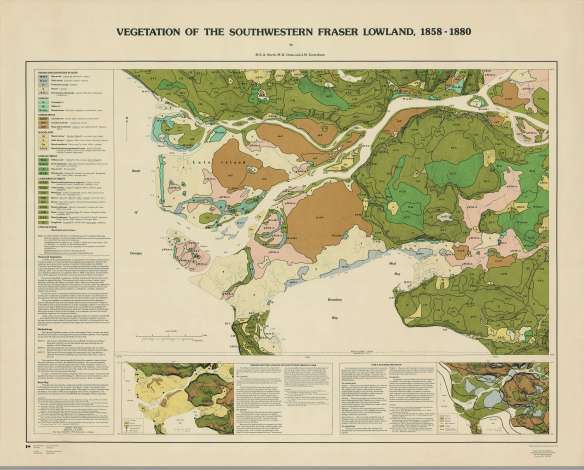
The low, slough-drained grass and shrub lands that supplanted the former track of this channel, which filled in around 1000 years ago, separated the east and west Richmond bogs, large sphagnum and cranberry bogs. The west part of Lulu Island was mostly slough-drained grass and shrub land, bordered on the west by the Crabapple Ridge, formed on an early beach berm. The higher banks of the island were edged by clusters of wet coniferous forest, spruce forests and alder scrub.

This map shows the types of vegetation existing in Richmond and the rest of the Fraser Lowlands between 1858 and 1880. City of Richmond Archives Map 1987 76 8.
The vegetation on Sea Island was mostly spruce forests on the east and central portions and grasslands and scrub around the north, west and south parts of the Island.
To the Coast Salish peoples of the area, Richmond’s islands were gardens, with cranberry bogs, crab apple trees and plentiful other plant resources. Deer grazed in the grassland and the sloughs were home to beaver, muskrats and mink as well as spawning salmon. Sturgeon and salmon were available in the river as well, and wildfowl were plentiful, especially during migration cycles. The natural sloughs were important transportation arteries, giving access deep into the islands. More than 100 km of the sloughs were navigable by canoe.
It is estimated that the population of the land now called Richmond was 1000 to 2000 people during the winter, but swelled to perhaps ten times that many during other times of the year, especially during the fishing season. Archaeologists estimate that as many as six permanent house sites existed on Lulu and Sea Islands as well as many fishing and short term camps, salmon weirs and other miscellaneous sites. The smallpox epidemic of 1781 decimated the population of the area leading to the abandonment of most of the sites, although many continued to be used by the First Nations peoples well after the arrival of European settlers.

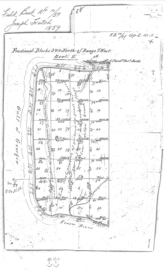
This is a copy from one of the original surveyor’s field books used by Joseph and John Trutch when they surveyed Lulu Island in 1859, showing some details of the land and vegetation of Lulu Island at the time. Trutch Field Book #10.
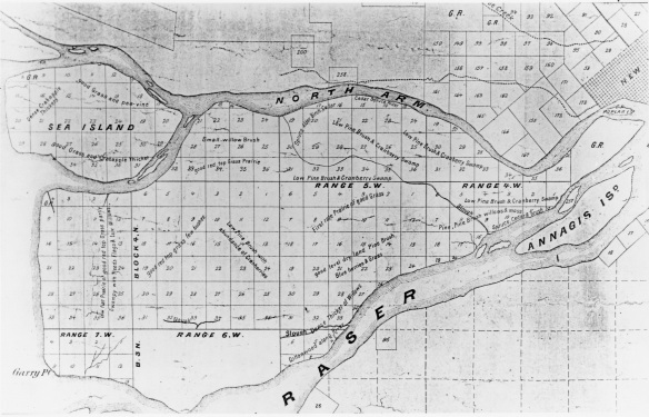
Richmond’s Islands were first surveyed in 1859 by Joseph and John Trutch who were awarded a contract from the Colonial Government to survey land along the Fraser River. From this survey we can glean some information about the land and vegetation of Richmond before European settlement. Missing on the 1859 survey is a large block of land in the South Arm “Slough District”, comprising Block 3 N Range 6 W, apparently skipped at the request of the Hudson’s Bay Company who were still actively trapping beaver there at the time. The survey of that section was completed by J.A. Mahood in 1874.

This early map of Richmond is based on the Trutch survey drawings and shows notes on vegetation. Note the blank space at the South Arm “Slough District”, an area not surveyed at the request of the Hudson’s Bay Co. City of Richmond Archives photograph RCF 17.
Early European settlers used the slough complexes for transport, much as the First Nations people had but, with the construction of roads through Richmond the sloughs became a hindrance to development, rather than the benefit they had been. Farmers and road builders built ditches and canals, dyked their property to prevent flooding and filled in the original sloughs. By the end of the First World War most of the natural sloughs in Richmond were gone.
Today very little of the original slough system remains and Lulu and Sea Islands are completely encircled by dykes with drainage systems and pump houses removing water from the land. Few people are aware of the original geography, vegetation and prehistory of the islands they call home.

Pingback: Canadian History Roundup – Week of February 17, 2019 | Unwritten Histories
Pingback: #EnvHist Worth Reading: February 2019 – NiCHE
Pingback: A Wild Childhood in the Ditches of Richmond - Today News Update