The North Arm of the Fraser – Industry in 1918

In October 1918, with the First World War nearly over, a group known as “The Joint Committee of the Boards of Trade of South Vancouver, Richmond and Point Grey” began to lobby the Federal Government to dredge the twelve miles of the North Arm of the Fraser between the river mouth and New Westminster. The shallow water in the North Arm at low tide caused fishing vessels, tugs and other vessels with a greater than three foot draft to run aground, stopping traffic to industries along its banks until higher water. This limited the amount of raw materials and product the industries could ship and discouraged new industry from building in the area. In an effort to motivate the government to their ends, the Joint Committee published a “memorial” for the attention of the Hon. F.B. Carvell, Minister of Public Works for the Conservative Government of the time, titled “The North Arm of the Fraser: Its Industries, Its Possibilities: A Plea for its Development”.

1987 91 1-5

The panoramic cover photo of the “memorial” shows some businesses in Marpole, which had changed its name from Eburne two years earlier. Shown are the Eburne Gravel Company and Eburne Sash, Door and Lumber, both at the foot of Hudson Street. City of Richmond Archives photograph 1987 91 1-5.

The document was signed by a diverse collection of politicians, industrialists, business owners, mariners and other citizens, all of them putting forth their justification for the dredging of the river. It also included a wonderful collection of photographs showing the North Arm and the industries along its shores in the early twentieth century.

1987 91 6-10

The first photo in the body of the memorial is this one of the North Arm Jetty. City of Richmond Archives photograph 1987 91 6-10.

The North Arm Jetty had been built and the mouth dredged some years before allowing vessels to enter the river on any stage of the tide and be protected from wind as they did so. Since then it was felt that the greater outflow caused lower levels farther up the North Arm and several shallow spots in the river preventing vessels with a deeper draft from proceeding up river until high tide. Logs would have to be placed into booming grounds down river where they could be picked up by smaller tugs rather than be delivered straight to the mills, increasing towing costs.

1987 91 19

The Huntting-Merritt Lumber Co. mill. City of Richmond Archives photograph 1987 91 19.

The Huntting-Merritt Lumber Company shingle mill was located at the foot of Granville Street on the Vancouver side of the river. They operated eleven shingle machines, day and night, and employed 100 men. Next door, the Eburne Sawmills Limited mill was having a difficult time handling logs and had to dredge their booming ground to allow the mill to keep employing 125 men at their mill.

1987 91 20

Logs bound for the Canadian Western Lumber Company are towed upstream toward the CP Railroad bridge. City of Richmond Archives photograph 1987 91 20.

1987 91 21

The Eburne Gravel Company Plant. City of Richmond Archives photograph 1987 91 21.

The Eburne Gravel Company sold builders’ supplies and coal and claimed that the difficulty of towing on the river cost them an additional 25 to 30 cents per ton for coal and 10 to 15 cents per yard of sand or gravel.

1987 91 22

The Graham Evaporating Plant at Marpole. City of Richmond Archives photograph 1987 91 22.

The Graham Evaporating Plant produced desiccated vegetables and green, dried, evaporated and canned apples, employing about 100 people. They handled about 25 to 30 tons of vegetables a day and employed 100 people. Most of their product was transported by “team” or rail but they felt that dredging the river would give them the opportunity to ship product by water, reducing costs.

1987 91 23

The Eburne Steel Company. City of Richmond Archives photograph 1987 91 23.

The Eburne Steel Company produced bar iron and steel ingots as well as other wartime necessities. They employed about 80 men. They were entirely dependent on rail transportation to receive their iron ore and ship out their products and said they would require tug and scow facilities to fully realize their business goals.

1987 91 24

The Dominion Creosoting and Lumber Limited lumber mill. City of Richmond Archives photograph 1987 91 24.

1987 91 25-27

The Dominion Creosoting and Lumber Limited creosoting plant. City of Richmond Archives photograph 1987 91 25-27.

The Dominion Creosoting and Lumber Limited operation in South Vancouver was also hampered by the problems of shipping their product to market. Their lumber mill employed 120 men. The creosoting operation had been idled because of a lack of creosote which was shipped from England. It was expected that when the war was over, this part of the plant would reopen and employ another 30 men. Their plant had the use of 1200 feet of river frontage. An improvement in shipping ability would greatly improve the profitability of their business. They claimed that theirs was only one of forty or fifty available industrial sites on the North Arm which could be developed if only the shipping issue could be rectified.

1987 91 36-40

The Canadian Western Lumber Company Limited mill at Fraser Mills is shown here with their fleet of tugs Joyful, Fearful, Cheerful, Gleeful and Dreadful. The Stern wheeler Senator Jansen is on the right and an unidentified small freighter loads on the left. City of Richmond Archives photograph 1987 91 36-40.

The Canadian Western Lumber Company Limited had a large operation at Fraser Mills, upriver from New Westminster. In their submission to the request for dredging they described the difficulty experienced by vessels going to their plant:

If the vessel and their tow enter the river at the beginning of the flood they can make it as far as Eburne as the force of the tide is spent and have enough water remaining to carry them through the Eburne Bridge, the Railway Bridge and Mitchell’s Bridge at Fraser Avenue. They then have to stay with their tows for 24 hours before being able to move again on the flood tide. On this flood they can make it as far as the New Westminster City Limits where they have to wait another 24 hours before proceeding to the mills past New Westminster.

1987 91 11

The Small and Bucklin Lumber Company Limited mill, New Westminster. City of Richmond Archives photograph 1987 91 11.

1987 91 12

The Brunette Saw Mill Company mill. In the background is the Iowa Lumber and Timber Company mill. City of Richmond Archives photo 1987 91 12.

The Small and Bucklin Lumber Company and the Brunette Sawmill Company each employed more than 200 men and both reiterated the complaints of other industries along the North Arm. Both plants were in New Westminster and had to wait for a couple of tides for logs to be delivered to their mills.

1987 91 13

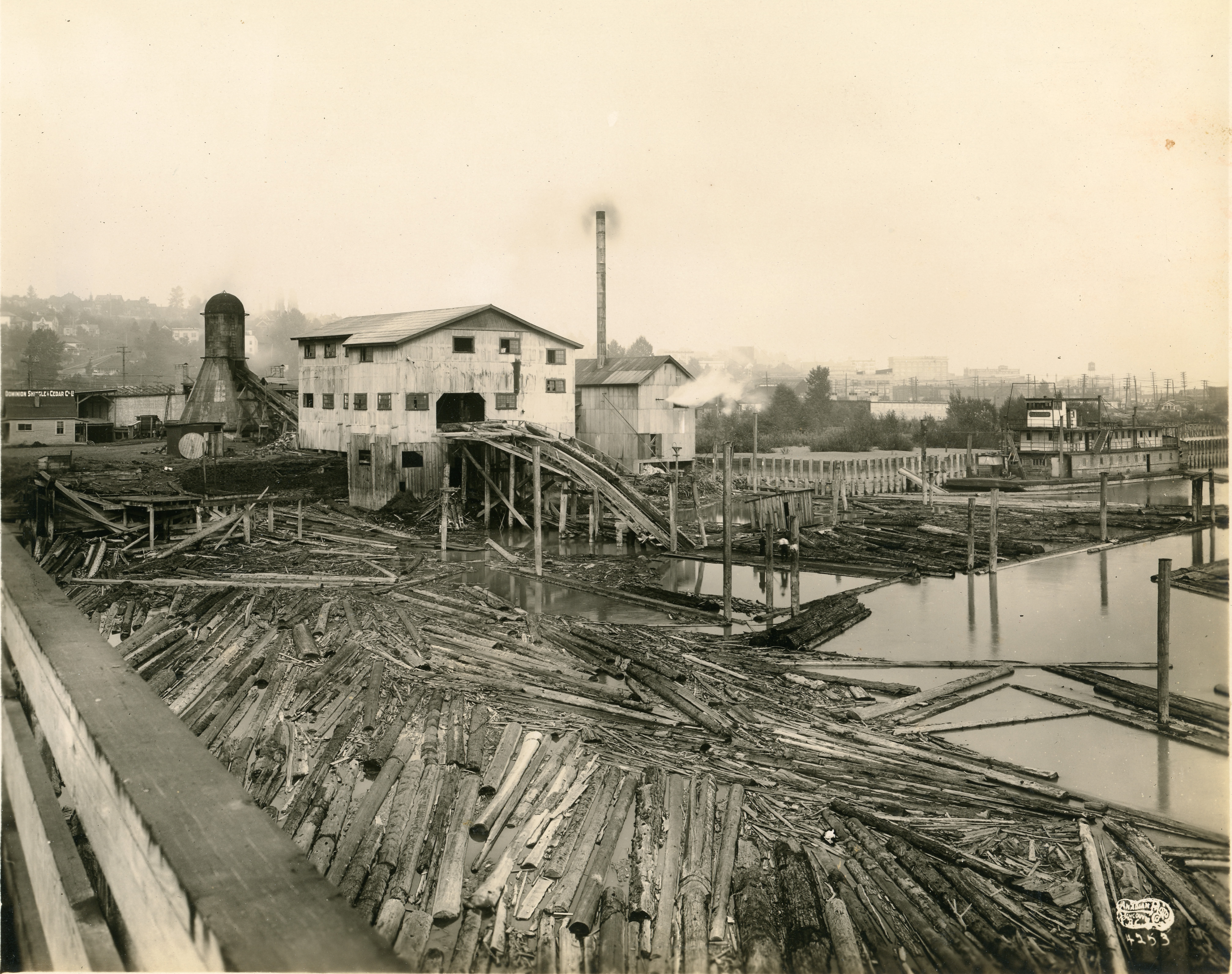
The Dominion Shingle and Cedar Co. is shown here in a photo taken from the old Queensborough Bridge. The skyline of New Westminster can be seen behind. City of Richmond Archives photograph 1987 19 13.

The Dominion Shingle and Cedar Company was located “at Lulu Island Bridge” (the old Queensborough Bridge) and employed about 50 men.

1987 91 14

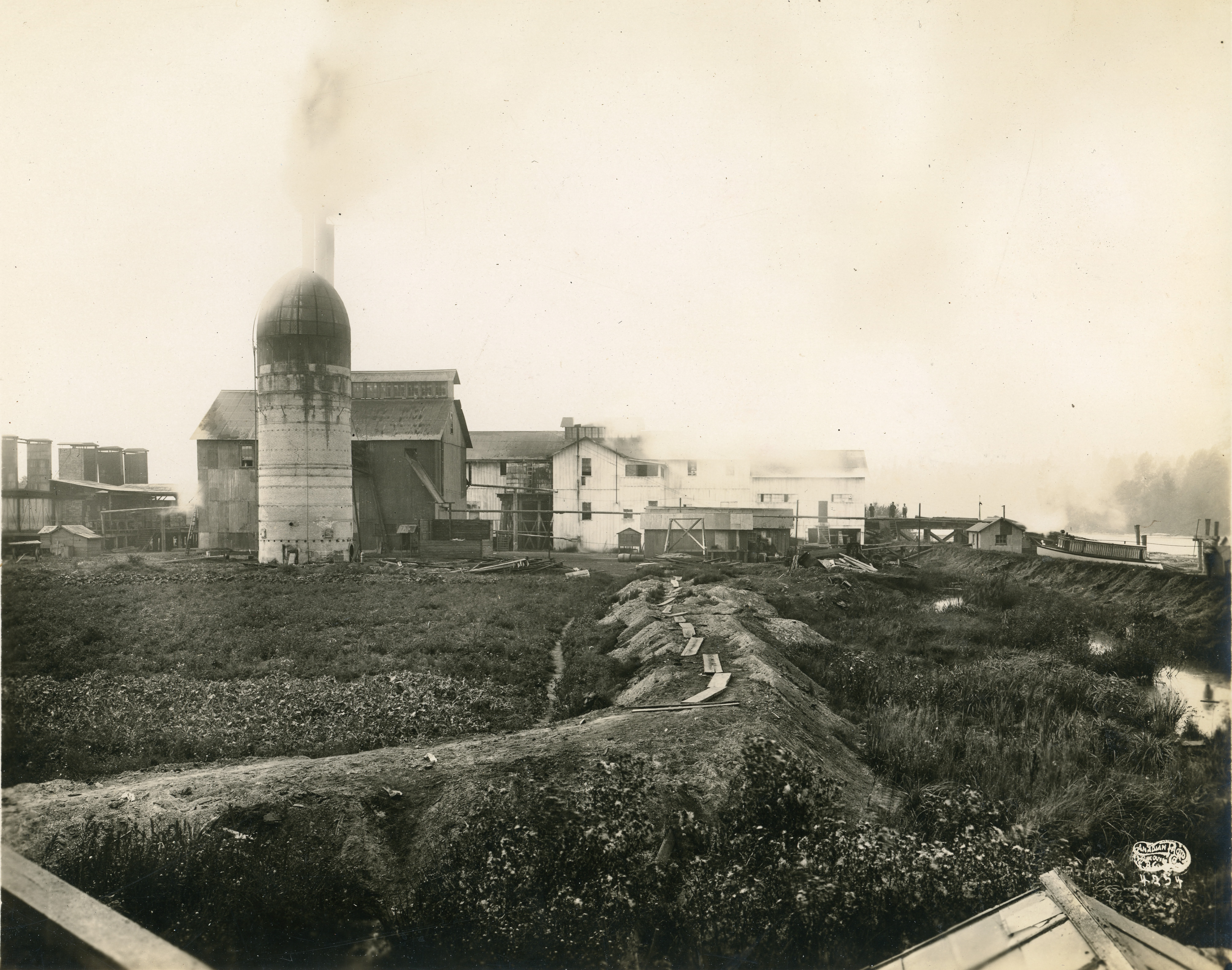
The Westminster Mill Company plant at New Westminster. City of Richmond Archives photograph 1987 91 14.

The Westminster Mill Company, manufacturers of red cedar shingles, operated two mills just below New Westminster which employed 200 men. Most of the logs used in the mill were brought up the river and delays in delivery due to low water levels seriously impacted their bottom line.

The arguments must have had some effect as dredging did take place on the North Arm in 1918. Reports indicate that a dredge tore out a two inch steel waterline that Jacob Grauer had installed from the mainland to supply water to his store and butcher shop as well as his neighbors at Eburne on Sea Island.

1987 91 15-18

The final image in the document shows a tug towing a boom up river and another tug bringing a barge down river past the wooded tip of Eburne Island as a BC Electric Railway Interurban Tram heads to New Westminster. City of Richmond Archives photograph 1987 91 15-18.

A Walk Down No. 3 Road in 1958

In 1974,  the Assessment Authority Act was passed in the BC Legislature allowing the formation of the BC Assessment Authority, an organization which operates independently from municipal or provincial governments to assess property values for taxation purposes. Before this the Corporation of the Township of Richmond had its own tax assessors who created assessment rolls to establish property values in the Municipality. In 1958, an assessor took his camera out to document the commercial buildings along No. 3 Road, mostly between its intersection with Westminster Highway and with Granville Avenue, and left us with a fascinating time warp back to the late 1950s in a location that has seen some of the greatest change in Richmond, although bits of it still survive. Lets take a stroll along No. 3 Road in 1958.

a 1988 18 7

The intersection of No. 3 Road and Westminster Highway looking north west. City of Richmond Archives photograph 1988 18 7.

Starting our walk at the intersection of No. 3 Road and Westminster Highway, we look toward the north west corner and the new, modern supermarket of Canada Safeway and its parking lot. This intersection, one of the busiest in Richmond then and now, was one of the first to have a traffic signal.

b 1988 18 8

On the north east corner of the intersection was the Lansdowne Service Shell station. City of Richmond Archives photograph 1988 18 8.

Across No. 3 Road from Safeway is Lansdowne Service, a Shell gas and service station. If you drive north along No. 3 Road, there were only trees between the station and Lansdowne Park Racetrack.

c 1988 18 9

Directly across Westminster Highway from Safeway was the Super-Valu Store. City of Richmond Archives photograph 1988 18 9.

On the south west corner of the intersection, directly across the street from Safeway is its main competition, Super-Valu. Their signs compete for attention on this corner.

d 1988 18 10

Turning around and looking south up No. 3 Road you can see the Ford dealership of Steveston Motors and the strip of commercial building an bit farther down. City of Richmond Archives photograph 1988 18 10.

Standing in front of Super-Valu and looking south along No. 3 Road you can see some of the commercial buildings on the west side of the street. Steveston Motors Ford dealership was just south of the Super-Valu store. Across the opening to their car lot is a strip of storefronts.

e1988 18 11

Looking south along No. 3 Road from the east side of the street. City of Richmond Archives photograph 1988 18 11.

If you cross No. 3 Road to the east side and look south you get a good view of Super-Valu, Steveston Motors and the row of commercial buildings. Let’s walk along the sidewalk a bit….

f 1988 18 6

Looking north toward Westminster Highway from the east side of No. 3 Road. City of Richmond Archives photograph 1988 18 6.

… and look north to see the businesses on the west side of the street, Safeway, Super-Valu and Steveston Motors. Judging by the banners and flags they’re really trying to sell those Edsels.

g 1988 18 35

Looking east along Westminster Highway from No. 3 Road. City of Richmond Archives photograph 1988 18 35.

If we head back down to the intersection we can look east along Westminster Highway and see a couple of businesses just around the corner, Lulu Billiards and Jerry Pickard Motors Austin Sales and Service.

h 1988 18 34

Lulu Island Motors on the coner of No. 3 Road and Westminster Highway. City of Richmond Archives photograph 1988 18 34.

Right on the corner of Westminster Highway and No. 3 Road is Lulu Island Motors, a Standard Oil (Chevron) station where you can get gas, a tune-up and new tires.

i 1988 18 33

Looking farther south the next building houses a number of businesses. City of Richmond Archives photograph 1988 18 33.

Next to Lulu Island Motors is a commercial building with a number of businesses. The Richmond Review Newspaper is through the first door at 604 No. 3 Road. Next door is the popular Rooster Cafe. Beside the cafe is the Farmerette Grocery Store and at the end is Marpole Cleaners. Upstairs are some lawyer’s and doctor’s offices and some apartments.

j 1988 18 32

The neon sign at the Rooster Cafe. City of Richmond Archives photograph 1988 18 32.

Looking up, the neon sign at the Rooster Cafe is Richmond’s finest.

k 1988 18 31

The Lulu Theatre. City of Richmond Archives photograph 1988 18 31.

Across a driveway, the next building is the Lulu Theatre, showing Hollywood’s latest movies.

l 1988 18 4

Looking north down No. 3 Road toward Westminster Highway. City of Richmond Archives photograph 1988 18 4.

Turning around and looking north down the west side of the street you can see the buildings housing The Canadian Bank of Commerce, Kleven’s 5-10-15 Cent Store, Pemberton Jewelers, Lansdowne Hardware (selling Bapco Paints), McCue Drugs, the Island Colour Bar (selling Canada Paints) and Richmond Tailors.

m 1988 18 5

Looking south west toward 621 No. 3 Road. City of Richmond Archives photograph 1988 18 5.

Turning and looking south west, next door to the bank is the Delta Esso Service Station. In the background are the buildings at Cunningham Lumber Co.

n 1988 18 30

Back on the east side of the street is Lang’s Nurseries. City of Richmond Archives photograph 1988 18 30.

Looking back to the east side of the street we find a long-time family owned Richmond business, Lang’s Nurseries. The propery is filled with trees, shrubs, plants, topsoil and anything else one needs for landscaping or gardening.

o 1988 18 3

Looking north west. City of Richmond Archives photograph 1988 18 3.

Back across the street is the Cunningham Lumber Co. (selling Glidden Paint) and the offices of J.M. Wells Construction Ltd.

p 1988 18 29

Looking north east toward the Bank of Montreal. City of Richmond Archives photograph 1988 18 29.

Back on the east side of the street again is the Bank of Montreal at the west end of the Hyland Park Shopping Centre. In the background, a ferris wheel from Royal Canadian Shows is set up in the empty lot between Lang’s Nurseries and Hyland Park.

q 1988 18 28

Looking south along No. 3 Road. City of Richmond Archives photograph 1988 18 28.

Turning south, we can see the sign for the Hyland Park Shopping Centre with a list of the businesses there. The Shop-Easy Grocery Store and its parking lot are just past the sign. Fastened to the telephone pole is a poster for Royal Canadian Shows at Brighouse  May 22 to 24.

r 1988 18 27

Looking north on No. 3 Road. City of Richmond Archives photograph 1988 18 27.

After walking along the street, crossing Cook Road and looking back, we can see the Hyland Park and Shop-Easy signs in the distance. Realtors Insurance and Home Builders Lumber (selling Monamel paint) are to the right.

s 1988 18 26

Simpsons-Sears Catalog Store. City of Richmond Archives photograph 1988 18 26.

Between Home Builders Lumber and this building is a large, mostly empty lot. This commercial building houses four businesses. Loreta Beauty Salon is in the ground floor left, Simpsons-Sears Catalog Store is on the ground floor right, P.A. Wolanski Accountant is upstairs on the left and the Marpole-Richmond Accordion College is upstairs on the right.

t 1988 18 24

The east side of No. 3 Road. City of Richmond Archives photograph 1988 18 24.

Next door is the Brighouse Branch of the Royal Bank of Canada and a Masonic Lodge, and next door to that is the Brighouse Bola-Drome bowling alley and cafe. A group of young guys with slicked back DA haircuts loiter outside and the advertising sign requests “Players Please!”

u 1988 18 25

Looking east to the corner of Park Road and No. 3 Road. City of Richmond Archives photograph 1988 18 25.

Crossing the intersection of Park and No. 3 Roads we come to Richmond Motors, a BA service station. Behind the station on Park Road is the office of  Richmond Cabs (Call CR-8-8444).

v 1988 18 23

Looking east toward 680 No. 3 Road. City of Richmond Archives photograph 1988 18 23.

Next to Richmond Motors the building at 680 No. 3 Road houses two businesses. Brighouse Hardware (selling Martin-Senour Paint) and Gordon’s Rexall Drugs.

w 1988 18 22

Looking east toward 682 No. 3 Road. City of Richmond Archives photograph 1988 18 22.

Beside the drug store, 682 No. 3 Road has four more retail outlets. Starting at the north end is Harris’ Bakery, Scoular’s Shoe Store, the Island Meat Market (Percy and Bob Eeles, proprietors) and Ivan’s Men’s Wear.

x 1988 18 21

Looking east toward 684 No. 3 Road. City of Richmond Archives photograph 1988 18 21.

Four more businesses occupy 684 No. 3 Road. Brighouse Television sells TVs, radios and appliances as well as doing service and TV antenna installations. Next door, Burrows Cleaners provides laundry service, including pick-up and delivery.  Dawn Marie Style Shop offers the latest fashions for ladies and they can go next door to shop for shoes to go with their new dress at Skuse’s Shoes. The small building next door at 686 No. 3 Road (Behind the big Cadillac) is Dr. Booth’s Dentist Office and Dr. Talmey’s and Dr. Varley’s doctor’s office.

y 1988 18 20

Looking east toward 688 No. 3 Road. City of Richmond Archives photograph 1988 18 20.

Just south of the doctor’s offices is a large two-storey commercial building  at the corner of Anderson Road and No. 3 Road. The first space is occupied by Richmond Realty with its clock sign and marquee which asks, “What Recession?”. Next to it is the Sea-View Bakery. Beside the bakery, a door leads to stairs to the second floor where Dr. Kita has his dental office, Dr. Fagen has his medical practice and where chartered accountant Donald Ross, and lawyers A.A. McDonald and F.R. Spry have their offices. At street level, the south corner of the building houses Porter’s Brighouse Pharmacy.

z 1988 18 19

Looking south east toward 690 No. 3 Road. City of Richmond Archives photograph 1988 18 19.

Across Anderson Road is an old wood framed commercial building holding the storefront of  Grayshon & Morgan Electrical Contracting and Plumbing Services. Next door is the Brighouse Beauty Shop, open Friday ’til 9:00 PM.

zz 1988 18 18

Looking east across toward 692 No. 3 Road. City of Richmond Archives photograph 1988 18 18.

Next to the beauty parlour at 692 No. 3 Road is Grassie Jewellers and next to that is a Richmond favorite, the Brighouse Cafe, offering “Good Food” in their Cafe and Dining Room. Next door is Island Glass who deal in “Glass of all kinds, for every purpose”, Lyall Grath, proprietor.

zzz 1988 18 17

Looking east toward 694 No. 3 Road. City of Richmond Archives photograph 1988 18 17.

At 694 No. 3 Road we find Richmond Home Furniture, a large furniture store offering trade-ins and good deals on all kinds of furniture and flooring. Next door is a two in one business, Naimark’s Dry Goods sells “Ladies and Kiddies Wear” and in the same store, Naimark’s Dry Cleaning cleans them.

zzzz 1988 18 16

Looking east toward 696 No. 3 Road. City of Richmond Archives photograph 1988 18 16.

The last building before Granville Avenue is the location of Richmond Hardware and the Brighouse Grocery – Red & White Store. The hardware store sells Bapco Paint, it seems like a lot of  places sell paint on No. 3 Road. The grocery store was a longtime business in Richmond, run by the Meyer Family. Upstairs, two apartments enjoy a balcony overlooking the street. Just across the street from this location is the Richmond Town Hall and just around the corner behind the store is Brighouse Station of the recently closed BC Electric Railway Interurban Tram.

zzzzz 1988 18 15

Looking east toward 700 No. 3 Road. City of Richmond Archives photograph 1988 18 15.

We’ll finish our walk down No. 3 Road by looking across Granville Avenue and No. 3 Road at the Parkview Service Garage. Brighouse Park is to the west of it and to the south is mostly houses. No. 3 Road between Westminster Highway and Granville offered most of the services anyone might need during the 1950s all contained within a few blocks. We’re fortunate that an unknown tax assessor decided to document this area and leave us with this detailed example of a point in time of Richmond’s development.

Vantage Point – Industry on the South Arm of the Fraser

Steveston Harbour showing canneries and fish boats, 1959. City of Richmond Archives Photograph 2010 87 29

Steveston Harbour showing canneries and fish boats, 1959. City of Richmond Archives Photograph 2010 87 29

A recent addition to the holdings of the City of Richmond Archives is an album of aerial photographs taken from 1959 to 1962 showing industry on the South Arm of the Fraser River, at New Westminster, and on the Upper Fraser.

The album was created by the New Westminster Harbour Commission with aerial photographs taken by George Allen.

Crown Zellerbach paper mill and wharf, 1959. City of Richmond Archives Photograph 2010 87 28

Crown Zellerbach paper mill and wharf, 1959. City of Richmond Archives Photograph 2010 87 28

Images from 1959 depict Steveston Harbour and the wharves of what were Richmond’s three major industrial plants on the South Arm: Crown Zellerbach Paper Mill, Canada Rice Mills, and LaFarge Cement.

Canada Rice Mills plant and wharf, 1959. City of Richmond Archives Photograph 2010 87 27

Canada Rice Mills plant and wharf, 1959. City of Richmond Archives Photograph 2010 87 27

The photographs were taken in the same year that the Deas Island (George Massey) Tunnel was opened.

La Farge Cement plant, showing Don and Lion Island, 1959. City of Richmond Archives Photograph 2010 87 31

La Farge Cement plant, showing Don and Lion Island, 1959. City of Richmond Archives Photograph 2010 87 31

The 52 photographs in the album are among a larger number of images that have been recently scanned as part of the ongoing Archives digitization program.

Vantage Point – The View from Richmond’s First High-Rise Development

In the shadows of the Park Towers complex, Richmond Square and beyond looking northeast, ca. 1974. City of Richmond Archives Photograph 1988 123 656

In the shadows of the Park Towers complex, Richmond Square and beyond looking northeast, ca. 1974. City of Richmond Archives Photograph 1988 123 656

Advertisement in Richmond Review newspaper, November 10, 1972. City of Richmond Archives newspaper collection

Advertisement in Richmond Review newspaper, November 10, 1972. City of Richmond Archives newspaper collection


The early 1970s saw the construction of Richmond’s first high-rise buildings, the 17-storey Park Towers complex off Minoru Boulevard.  The three-tower project was designed by Erickson-Massey Architects under the terms of the municipality’s first land use contract. Prior to this time, the highest building in Richmond was Richmond General Hospital, at a height of 6 storeys.

The first two towers (“C” and “B”) opened for occupancy in 1972 and were designed as rental accommodation. The final tower (“A”) was completed the following year and became condominium housing.   The Towers were advertised as a place for “luxurious living …in the heart of Richmond.”


Richmond Square, No. 3 Road and beyond looking east, ca. 1974. City of Richmond Archives Photograph 1988 123 652

Richmond Square, No. 3 Road and beyond looking east, ca. 1974. City of Richmond Archives Photograph 1988 123 652

Shortly after construction of the final tower, Engineering Department staff took photographs from the building of its surroundings, including Richmond Square (now Richmond Centre Mall) to the east and Minoru Park to the west. These slides were recently described and scanned as part of the City of Richmond Archives’ ongoing digitization program.

Richmond Twin Theatres, Municipal Hall and beyond looking southeast, ca. 1974. City of Richmond Archives Photograph 1988 123 654

Richmond Twin Theatres, Municipal Hall and beyond looking southeast, ca. 1974. City of Richmond Archives Photograph 1988 123 654

The images provide a view of Richmond’s Town Centre in transition at the beginning of its rapid development through the 1970s and 1980s.

Minoru Park (with Minoru Chapel) and beyond looking northwest, ca. 1974. City of Richmond Archives Photograph 1988 123 660

Minoru Park (with Minoru Chapel) and beyond looking northwest, ca. 1974. City of Richmond Archives Photograph 1988 123 660

[Note – this is an updated version of an article first published in the Spring 2015 issue of the Archives News]