Japan Town – Steveston in the 1930s

Richmond has a long and rich history of Japanese immigration and settlement. Various places around Richmond, Sea Island, Don Island and, in particular, Steveston were areas where Japanese immigrants lived, worked, raised families and contributed to the diverse cultural blend of our city.

Steveston looking west along Moncton Street from No.1 Road around 1940. The majority of the businesses along this street were operated by Japanese-Canadian entrepreneurs at the time. City of Richmond Archives photograph RCF 274.

Japanese immigrants (Nikkei) arrived in Steveston around the time that the English Cannery opened in 1882 and by the 1900s made up a large portion of the Steveston population. Mostly male and mostly fishermen, they were accommodated in bunkhouses built by the canneries. During the fishing season Japanese “Bosses,” who had control of twenty or thirty boats, would negotiate contracts with the canneries for them and take care of their needs such as food, clothing and other services in return for a percentage of their wages.

This image taken on November 22, 1936 shows members of the Japanese community gathered outside the Japanese Buddhist Mission on First Avenue to commemorate the ceremony of “Putting in the Buddha.” City of Richmond Archives photograph 1995 3 1.

Although the original intention of many of the men was to return to Japan after working in Canada, many decided to stay permanently. Some returned to Japan to find wives, others had their families back home arrange marriages with suitable women, the so-called “Picture Brides”. Bunkhouses were unsuitable for married couples, so canneries built small houses to accommodate families.

A group of Japanese girls pose for a picture in traditional May Day dress outside the Steveston Japanese School ca. 1926. City of Richmond Archives photograph 1978 1 36.

The Nikkei population grew, the men fishing and their wives working in the canneries and raising families. They diversified, expanding into boatbuilding, buying property, farming and starting businesses. People joined Faith communities, formed sports teams and created a rich community life.

The Steveston Fuji baseball team played in the Vancouver Japanese League with the Asahi Giants, Powell Drugs and Union Fish teams. City of Richmond Archives photograph 1977 7 12.

Contending with discrimination and exclusion, The Japanese Fishermen’s Benevolent Society was formed in 1897 to protect the interests of the Nikkei fishermen and the community, A 1906 decision by the Richmond School Board to ban children of non-property owners effectively deprived most of the Nikkei children of an education and resulted in the construction of the Steveston Japanese School. To ensure that the health needs of the community were met, the Japanese Fishermen’s Hospital was built, Richmond’s first.

The Japanese Fishermen’s Hospital on No.1 Road in Steveston, ca. 1915. City of Richmond Archives photograph 2006 39 47.

By the 1930s the Japanese population had grown to account for two-thirds to three quarters of the total population of Steveston, approximately 3500 people. Nikkei owned businesses and stores of every description lined Moncton Street from No.1 Road to Third Avenue. Grocery stores, meat and fish markets, hardware and general stores, a bicycle shop, the River Garage, a billiard hall and clothing stores operated by Nikkei entrepreneurs could be found on both sides of the street. Five confectioneries (candy and chocolate shops) satisfied those with a craving for sweets.

The Mukai Confectionary stood at the corner of Moncton Street and No.1 Road and had a confectionary in the front, a pool hall in the back and ten bedrooms upstairs. It also housed a taxi business and had space used by a dentist who came to Steveston once a week. The building was lost in a fire sometime between 1942 and 1951 but the location is still known as Mukai Corner. City of Richmond Archives photograph RCF 272.

The density of the Japanese Canadian population in Steveston is very obvious when looking at the meticulous research done by Haruji (Harry) Mizuta who, using maps from the 1936 Waterworks Atlas of Richmond, marked the locations of Nikkei homes and businesses from the Scottish Canadian Cannery in what is now Garry Point Park to the Winch Cannery at the foot of No.2 Road. This is especially true with the map he marked as #30-2 1930s – Gulf of Georgia Cannery and Old Steveston Town – Steveston BC.

This map, created by Haruji (Harry) Mizuta illustrates the quantity of Nikkei homes and businesses, marked by blue and red dots, in Steveston during the Thirties. City of Richmond Archives Reference Files.

The growth of “Japan Town” came to a sudden halt with the forced relocation of Japanese Canadians from the Coast of British Columbia. Families were uprooted, stripped of their property and moved to areas where they had to start over and rebuild their lives, often in harsh circumstances. Steveston became a virtual ghost town with so many of its residents suddenly gone. In 1949 when Nikkei families were permitted to come back to the coast, those who decided to return rebuilt their lives and community again. Today the legacy of Japan Town is a cherished and honoured part of Steveston’s and Richmond’s history.

Haruji (Harry) Mizuta’s research shows some of the businesses and business owners along Moncton Street during the 1930s. City of Richmond Archives Reference files.

Richmond on the Home Front

World War 2 was the greatest armed conflict in history, a truly global war in which Canada played an important part. The entire country was focused on working toward a speedy victory for Canada and her allies through the formation of a strong military force and production and supply of goods and materials in support of the war effort.

Richmond sent many of her young men and women to serve in the military, at home and overseas, many of whom paid the ultimate price for their service. Their sacrifice is remembered every year on Remembrance Day.

On the home front in Richmond, everyday life steered toward supporting the military in its work. Under the National Registration Regulations, enacted in 1940, all persons in Canada, age 16 or over, were required to register with the government, supplying details of their age, family, work history, national and racial origins, etc. This allowed the authorities to direct the service of each person, whether that lay in the military, in war production, or in the maintenance of services allowing life in the nation to continue in a routine manner.

Registration All persons aged 16 and over were required to register for service during the war. Ad from Marpole-Richmond Review July 31, 1940.

Everyday Life in Wartime

Rationing of materials became commonplace. Items such as gasoline and other fuels, rubber goods, like tires, and metals were either not available or could only be purchased using ration coupons. The same was true for many household items like sugar, meat, coffee, etc. Many guides were published to help people deal with shortages and the reduced quantities of goods that they could get. Programs were put in place and drives were held to collect scrap material like metals, scrap paper, cooking grease and bones, etc., all to go to wartime industry.

How to Solve

Guides to help people deal with rationing were published by many companies and government agencies, such as this one from Canadian General Electric. City of Richmond Archives reference files.

Home Canning Ration Guide

And this one from B.C. Tree Fruits Ltd. City of Richmond Archives reference files.

Calls for volunteers for organizations like the Red Cross and the Home Defence Corps were met by local residents who contributed their time away from other jobs to take part. Women and teenagers too young for the military took over many of the jobs which had been vacated by men leaving for military service.

Boeing Beam -oct 13 -1943

Women are trained to assemble aircraft at the Sea Island Boeing Plant in this image from 1943. Boeing Beam  October 13,1943.

Women Safe at Work-1

This booklet produced by Boeing Canada gave new female employees tips on how to be safe in an industrial setting, which until the war was unavailable to them. City of Richmond Archives reference files.

In March 1942, the National Selective Service was enacted “to effect the orderly and efficient employment of the men and women of Canada for the varied purposes of war.” Administered through the Department of Labour, the act allowed the government to dictate which jobs got preference for manning and gave them the power to move people out of low priority jobs and into higher ones.

selective

The National Selective Service Mobilization Regulations gave the Department of Labour sweeping powers over manpower in Canada.

Manning shortages were a continual problem in Richmond during the war, not in small part to the removal and internment of around 2,500 Japanese-Canadians from the area in early 1942.

farmhelp

Regular ads appeared in newspapers looking for labourers for farms and workers in other areas were encouraged to do extra work as farm workers.

The fishing industry imported workers to fill the void and there were regular ads in local papers looking for farm workers during planting and harvest periods.

1985 4 1753

Hundreds of fishboats, confiscated from Japanese-Canadians in 1942, sit at Annieville. Property that was confiscated such as boats, houses, businesses, etc., were never returned to their owners after the war. City of Richmond Archives, Photograph #1985 4 1753.

The people of Richmond signed up in droves for the many War Bond drives that were held during the war to help finance Canada’s War effort.

Protecting Richmond

The protection of Richmond’s people and infrastructure from potential attack was a priority during the war. At Steveston an army camp and shore battery was built to guard the mouth of the Fraser River. It was equipped with an 18 pounder artillery piece, later replaced by two 25-pounder guns. Four anti-aircraft batteries were installed to protect the airport, flight training school and aircraft plant – three on Sea Island and one on Lulu Island. Local residents were warned to open all the windows in their houses during target practice, a strategy which did not always prevent cracked windows.

2013 49 2

This anti-aircraft battery and camp was located just north of Granville Ave. near the Interurban Tram Line where it curves onto Railway Ave. City of Richmond Archives, Photograph #2013 49 2.

More than 90 men signed up to enlist in No.125 (Richmond) Company Pacific Coast Militia Rangers, Richmond’s home guard unit. Given military training, these men would have made the first response to any attack on the area.

1988 17 1a

Members of No. 125 (Richmond) Company Pacific Coast Militia Rangers pose in September 1945. These men formed Richmond’s home guard unit during the war. City of Richmond Archives, Photograph #1988 17 1a.

Richmond’s Volunteer Firefighters formed Canada’s first Air Raid Precaution unit, building much of their own equipment and putting in countless hours fighting fires and enforcing the Blackout imposed on coastal areas to protect against nighttime attacks.

Marpole-Richmond Review 1944-04-26-4

This ad for the sixth Victory Loan drive from an April 1944 Marpole-Richmond Review featured Richmond’s Volunteer ARP / Firefighters. The Steveston volunteers formed the first ARP unit in Canada, building most of their own equipment, including a fire truck. Marpole-Richmond Review April 26, 1944.

Wartime Industry

The largest employer in Richmond during the War was the Boeing Canada aircraft plant on Sea Island. The plant worked through most of the war building Consolidated PBY-5a amphibian patrol bombers, known as Catalinas in American service and Cansos in Canadian service. Toward the end of the war the plant made parts for the B-29 Superfortress bomber which were shipped south to a plant in Renton, Washington where the planes were completed.

1985 199 1

The hull of a PBY-5a patrol bomber is lifted by a crane in the Boeing Canada aircraft plant on Sea Island. 362 PBYs were built during the war at this plant which employed around 7,000 people at its peak. City of Richmond Archives, Photograph #1985 199 1.

About 7,000 people were employed at the plant during its peak. A shortage of housing for its workers led to the development of Burkeville, named for Boeing Canada president Stanley Burke.

Boeing Beam - Vol. 2 No. 18 Burkeville

The front page of the Boeing Beam newsmagazine featured a story about Burkeville, built to house workers at the aircraft plant. Boeing Beam September 1, 1944.

The peat mining industry had one of the highest priorities for manning during the war.  Sphagnum moss was used as a catalyst for the extraction of magnesium, used in the production of incendiary devices and munitions, and it was shipped to the US in large quantities from Richmond. Several large bog fires during the war interrupted production and resulted in the loss of thousands of dollars worth of peat.

1978 3 25

Stacks of peat blocks dry in a Richmond field in this photo. Peat mining was a very important industry during the war. It was used in the processing of magnesium which was vital for the production of munitions. City of Richmond Archives, Photograph #1978 3 25.

The need for large amounts of food products put Richmond’s fishing and farming industries on full production. Products from our area were shipped out for use by the military as well as to provide much needed supplies for Great Britain and our other allies in war ravaged areas.

1985 4 1759

Food production was another industry that was vital to the war effort. “Salmon for Britain” was a slogan used to encourage productivity in local canneries. City of Richmond Archives, Photograph #1985 4 1759.

Smaller industries, such as lumber production, fabrication and machine shops also contributed to the war effort, all under the control of the Department of Munitions and Supply, a civilian organization led by Minister C.D. Howe, who controlled the supply of all goods deemed necessary for the war.

Once the war was won, life gradually returned to normal. Men demobilized from the armed forces returned to the work force, displacing the women who had replaced them. The Boeing Canada aircraft plant ceased operation almost immediately after VJ Day, displacing more workers. Products which were rationed during the war became more readily available. Military groups charged with local defense were disbanded and Richmond’s ARP force returned to being volunteer firemen with no blackout to enforce. It took several more years before some of the Japanese-Canadian families who had been interned began to return.

For some, life would never be the same. Servicemen who were lost during the war left loved ones behind whose lives were changed forever and each year we remember their sacrifice.

Lest We Forget

Island City by Nature – Richmond’s Islands

Richmond is an island city. Built on land created by the action of the Fraser River, our city stands entirely surrounded by flowing waters which continue to deposit land on our shores. Richmond’s boundaries have changed several times over its history but were set in its final configuration in 1934. At that time 26 named islands were included inside our municipal limits. Many were and remain little more than tidal marshes but others became the foundation of today’s city with its agricultural, industrial and residential land.

When Richmond was first incorporated in 1879, its boundaries were defined by the shorelines of Sea and Lulu Islands. This included the Middle Arm and its islands and also  the part of Lulu Island which is now Queensborough,  part of the City of New Westminster.

In 1885 the Corporation of the Township of Richmond extended its boundaries. They now followed the north shore of the North Arm and included all the islands in it. The southern boundary of Richmond was also extended out into the South Arm of the River adding many of the islands there to the Municipality. At this same time, Queensborough was ceded to New Westminster.

In 1910 the boundaries were moved again when the City of South Vancouver extended its boundaries into the North Arm. The new border extended 200 feet south of the low water mark following the shore and reduced Richmond’s area accordingly.

In 1934 a newly enacted bylaw extended Richmond’s boundaries to include ” all the area, lands, foreshore and lands covered by water” lying within its boundaries. The Richmond Municipal Boundaries Extension Bylaw defined the present limits of our city which includes these islands.

1935 Aerial Mosaic of Richmond

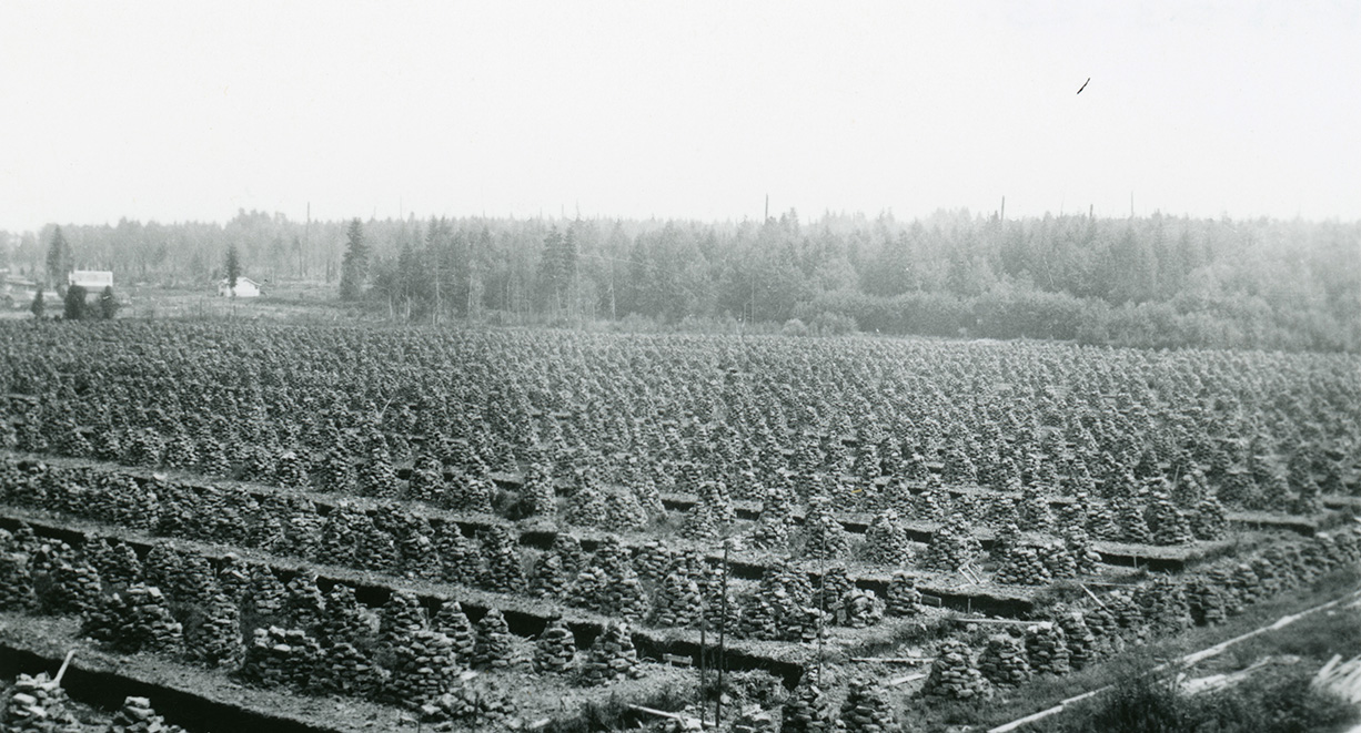
The 1935 Aerial Mosaic of Richmond shows Richmond with all of the 26 islands as they were when the Municipal boundaries were set. City of Richmond Archives image.

Lulu Island – The largest island in the group and home to most of Richmond’s population, industry and agriculture, Lulu Island was named for San Francisco actress, singer and dancer Lulu Sweet, as reported in another posting in this blog. (See https://richmondarchives.ca/2016/09/22/whats-in-a-name-lulu-island/  for more information. ) The island was originally two islands, separated by a channel which flowed northwest from Annacis Island in the South Arm to Mitchell Island in the North Arm. The channel was formed by three large sloughs, the main one being known today as Bath Slough.

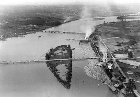
Sea Island – Richmond’s second largest island, Sea Island was probably named by Captain George Henry Richards who included the name in charts dating from the 1850s. Acknowledged to be the location of the first European homestead in Richmond, Sea Island was once mostly farm land and home to the small communities of Eburne, Burkeville and the Cora Brown subdivision. The island was also the location of the Vancouver and Acme Canneries and, before the Second World War, a large Japanese community. ( See https://richmondarchives.ca/2015/01/06/japanese-canadians-on-sea-island/  for more.) Selected as the location of the Vancouver Airport, which opened in 1931, the continuing expansion of the facility has resulted in the expropriation of agricultural and residential land on the island. The community of Burkeville is the only remaining population centre and farming has been greatly reduced.

The North Arm

Iona Island – Located at the north west end of Sea Island at the mouth of the North Arm, Iona Island is the present home of the Iona Island Wastewater Treatment Plant and the Iona Beach Regional Park. Once little more than a large sand bar, the island was farmed early in its history. It is connected to Sea island by a causeway and was once considered as a potential location for a ferry terminal.

1985 166 12

Iona Island, shown here ca. 1930, is now connected to Sea Island by a causeway and is the home of a large sewage treatment plant and a regional park. The Richmond-Vancouver boundary runs down the middle of the North Arm Channel at the centre of this photo. On the right is Deering Island on the Vancouver side of the channel. City of Richmond Archives photograph 1985 166 12.

Woods Island – This island, located on the north side of Sea Island, is the present day home of McDonald Beach Park with its boat launch, picnic areas and off leash dog park and is hardly a separate island anymore.

1935 Aerial Mosaic of Richmond dtl3

This detail from the 1935 Aerial Mosaic shows the islands surrounding Sea Island. In the North Arm, left to right, are Iona Island, Wood’s Island (tucked in close to the north shore of Sea Island) and Richmond Island, close to the Vancouver side of the channel. In the Middle Arm, left to right, are Swishwash Island, Dinsmore and Pheasant Islands and Duck Island, where the North and Middle Arms join. City of Richmond Archives image.

Richmond Island – Also known as Jimmy’s Island, Richmond Island was the home of the Richmond Cannery from 1882 until around 1909. The island was also home to a hermit, a black man named Jimmy, who might have lived in one of the abandoned cannery buildings. Early Geological maps also indicate that the island was farmed, divided into four lots protected by dykes. Today the island is home to a marina and boatyard as well as a bar and grill. Richmond island is only accessible from the Vancouver side of the river via West 75th Avenue and Bently Street, across a causeway.

~

The next three islands were once separate, but have all been joined and form what is now known as Mitchell Island. These islands were all named for the early pioneers who settled or farmed them.

1935 Aerial Mosaic of Richmond dtl1

This detail shows the three islands which make up the present Mitchell Island, left to right, Eburne Island, Twigg Island and Mitchell Island. City of Richmond Archives image.

Eburne Island – Eburne Island was named for Harry Eburne who lived there for a period of time. Mr. Eburne also gave his name to the community which grew up on both sides of the bridge to Sea Island. The island was also known as Anderson Island.

Twigg Island – Twigg Island was also farmed by it’s namesake J.J.C. Twigg.  Mr. Twigg served as a Richmond Councillor in 1905 and 1906. Twigg Island once joined the two spans of the Fraser Street Bridge which connected Fraser Street in Vancouver to No,5 Road in Richmond.

Mitchell Island – Named for Richmond pioneer Alexander Mitchell, this island is the largest of the three which now form a single large island in the North Arm. A large island with a lot of industrial activity on it, it is accessible using the Knight Street Bridge.

~

Tree Island – Probably named because of the trees which covered it, Tree Island is located in the North Arm just west of the border with Queensborough. The island is more of a peninsula now, infilled at its east end and connected to Lulu Island, but retains its name due to its occupation by the Tree Island Steel Company which has been in operation there for more than 50 years.

1983 6 78TreeIsland

Tree Island, shown here ca. 1960, is the location of the Tree Island Steel Co. and is now more of a peninsula of Lulu Island than a separate Island. City of Richmond Archives photograph 1983 6 78.


The Middle Arm

Swishwash Island – Little more than a tidal marsh, in the late 1880s Swishwash Island became the location of the Sea Island Cannery which burned to the ground in 1899. It was owned and operated by Alexander Ewen and Daniel Munn and pilings from the cannery can still be seen. Dredging spoil enlarged and raised the island to its present state in the 1950s. BC Packers owned Swishwash for many years and donated it to the Nature Conservancy of Canada when the company divested its fishing industry properties.

1997 5 9

At the lower right in this aerial photo, part of Swishwash Island is visible with the pilings of the Sea Island Cannery visible at its tip. Dinsmore and Pheasant Islands are also visible in the channel to the right of the houses of Burkeville. City of Richmond Archives photograph 1997 5 9.

Dinsmore Island – Dinsmore Island, also known as Brough Island, was located in the Middle Arm off the southeast corner of Sea Island. It was named for pioneer John Dinsmore who farmed the island and was an owner of the Dinsmore Island Cannery. The cannery was built in 1894 and was demolished in 1913. The Island was farmed for many years by several owners but by 1952 had become a part of Sea Island due to infilling of the channel. The name is remembered in the Dinsmore Bridge which connects Lulu Island to Sea Island via Gilbert Road, the north end of which sets down on the former island.

1984 17 84 Burkeville

This aerial view of Burkeville, ca. 1944, also shows Pheasant Island and Dinsmore Island connected to Sea Island by a bridge. Both Islands were farmed during their history. City of Richmond Archives photograph 1984 17 84.

Pheasant Island – Pheasant Island was a small island which was just off the north end of Dinsmore Island. Also used as farmland, it was absorbed by Dinsmore Island by channel infilling and thence into Sea Island.

Duck Island – (Middle Arm) – One of two islands inside the Municipality with the name, Duck Island was located between Lulu and Sea Islands at the north end of the Middle Arm of the river. The bridge to Sea Island passed over the island whose channel was used for log storage, wood processing mills being located nearby. A failed attempt to rezone Duck Island as parkland was made in the 1950s after it was approved for dredging spoil disposal. By 1972 the island had been absorbed by Lulu Island and is the present location of the Richmond Night market, a parking lot and the parkade for the River Rock Casino Resort. The last vestige of the island can be seen in the small slough and marsh area near the casino which once formed part of the Duck Island Channel.

2001 26

Duck Island is shown here, ca. 1919, supported part of the bridge to Eburne on Sea Island. Its channel was used as a log storage pond. The island has been completely absorbed into Lulu Island. City of Richmond Archives Accession 2001 26.


The South Arm

Don Island – Also known as Oikawa Island, Don Island is located in the South Arm of the river west of Annacis Island. It was settled, as was Lion Island, in 1902 by a group of Japanese fishermen and their families, led by entrepreneur Jinsaburo Oikawa,  who supplied fish to and worked at the Ewen Cannery.

Lion Island – Also known as Sato Island, Lion Island was the location of Alexander Ewen’s Cannery, for many years the largest on the Fraser River. The cannery, built in 1876, made “Lion Brand” salmon well known around the British Empire. The cannery closed in 1930, but Lion and Don Islands remained inhabited until the last of the Japanese families were removed in the 1942 internment.

2010 87 31

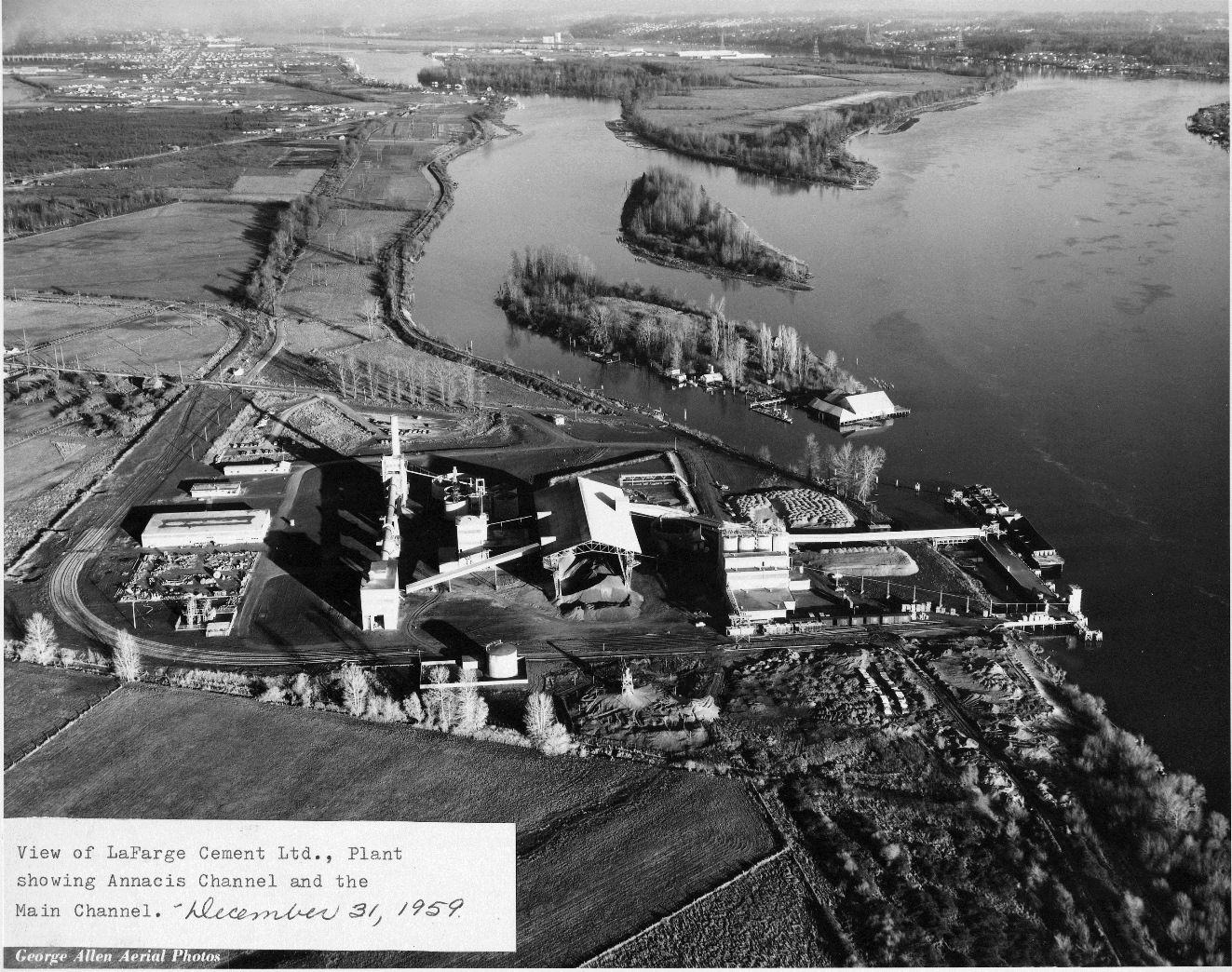
This aerial view from 1959 shows Lion and Don Islands in the Annacis Island Channel. The Ewen Cannery can be seen on the tip of Lion Island. City of Richmond Archives photograph 2010 87 31.

Whitworth Island – Also known as Gilmore Island, Whitworth Island is separated from Lulu Island by Finn Slough.

~

The next eight islands are located in what is known as the Ladner Reach of the South Arm of the Fraser River. All formed by alluvial deposits from the river, they have been affected by the erection of the Woodward Training Wall, which directs the flow of the river to stabilize the south bank, and by the dyking and farming of some of them. The islands fall within the Agricultural Land Reserve and are under the administration of the BC Ministry of Environment as the South Arm Marshes Wildlife Management Area.

1935 Aerial Mosaic of Richmond dtl2

This detail from the 1935 Aerial Mosaic shows Richmond’s islands in the Ladner Reach. On the right (marked) is Kirkland Island with Rose Island to its left. Rose Island is connected to No.1 Island by the white line of the Woodward Dam which continues down the channel as the Woodward Training wall, through Woodward’s Island. South of Kirkland Island is Williamson Island, then Gunn Island and in the most southerly part of the channel is Barber Island. South of Rose Island is Frenchie’s Island and Duck Island. City of Richmond Archives image.

Kirkland Island – Kirkland Island, named for Ladner resident John Kirkland, is a tidal marsh in the South Arm of the river, owned by the Nature Trust of British Columbia. The island has been dyked and farmed for many years.

Rose Island – Also conserved by the Nature Trust, Rose Island had been dyked and farmed. The channel between Rose and Kirkland Islands has filled in to the point that the two islands are often called Rose-Kirkland Island.

Williamson Island – Williamson Island is a small island south of Kirkland which is also conserved by the Nature Trust. It has been dyked and farmed,

Gunn Island – Another island which was dyked and is farmed, Gunn Island is south of Williamson Island.

Frenchie’s Island – A small privately owned island, Frenchie’s Island is located between Rose and Duck Islands.

Duck Island – (South Arm) – The second island with the name, Duck Island is west of Gunn Island and roughly in the centre of the estuary. An old cannery was located on the island and the pilings can still be seen.

Barber Island – Named for Alfred and Charles Barber, who acquired the island in 1888, Barber Island is the most southerly of Richmond’s islands in the estuary.

No.1 Island – This is a very small island north of Duck Island. The Woodward Dam, part of the Woodward Training Wall, spans the channel between No.1 Island and Rose Island and then runs from No.1 along Woodward’s Island for a distance of 3.7 km.

Woodward’s Island – Named for Nathan and Daniel Woodward who owned the island. Woodward’s Island is the most westerly of Richmond’s South Arm estuary islands.

~

Steveston Island – Originally no more than a sand bar, Steveston Island, also known as Shady Island, was formed by the dumping of dredging spoil and the erection of training structures in the river. It protects the Steveston waterfront. (For more about Steveston Island see https://richmondarchives.ca/2017/03/30/shady-island/)

1988 10 136

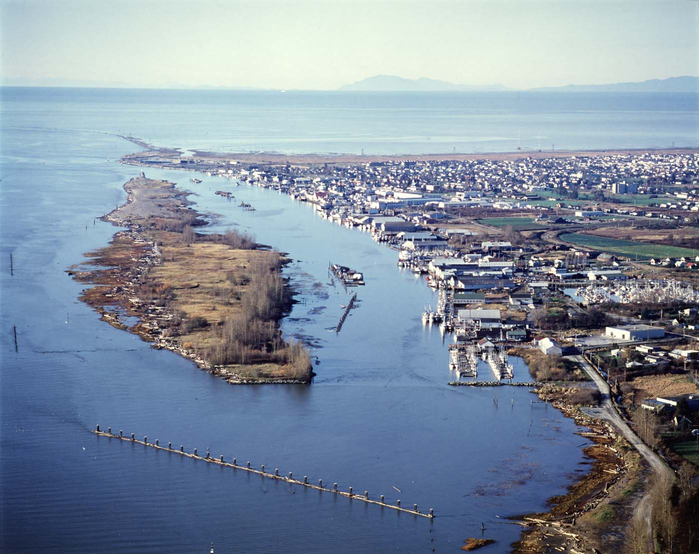
Probably the last of Richmond’s Islands to be formed, Steveston (Shady) Island was not much more than a semi-submerged sandbar before dredging spoil and river training devices added to its growth. City of Richmond Archives photo 1988 10 136.

Richmond’s original 26 islands have been reduced due to infilling to 19 which, arguably, could still be referred to as islands, still a respectable amount and more than enough for Richmond to qualify as an “Island City by Nature” and a “Child of the Fraser”.


Dr. R. W. Large – Medical Missionary in Steveston

The Japanese Methodist Mission was established in Steveston in 1896 to serve the needs of the Japanese fishermen of the area, offering spiritual and moral guidance as well as providing medical assistance when needed. A small building was erected on the property of the Phoenix Cannery to house the mission.

2012 3 8

The Methodist Japanese Mission in Steveston, ca. 1898, with several early missionaries posing on the stairs. Rev. Thomas Crosby is at top right, (with beard), Dr. R.W. Large directly in front of him. (City of Richmond Archives photograph 2012 3 8)


Almost as soon as it was ready, an outbreak of typhoid fever made it necessary to use the building as a hospital. The hospital operated for two years with the help of volunteer Japanese nurses.

2012 3 3

The Methodist Japanese Mission set up as a hospital ward. (City of Richmond Archives photograph 2012 3 3)

In 1898 the Canadian Methodist Church hired Dr. Richard Whitfield Large ( 1874 – 1920 ) to work at the mission during the fishing season.

2012 3 1

Rev. R.W. Large, MD. (City of Richmond Archives photograph 2012 3 1)

Dr. Large was the son of a Methodist Minister in Ontario and graduated from Trinity Medical College in Toronto.  The photographs shown in this post were taken during his two seasons in Steveston and offer a view into the primitive conditions encountered by doctors serving the small communities on the coast of British Columbia. They were donated to the Archives by a member of his family.

2012 3 6

Dr. and Mrs. Large in the Doctor’s office in Steveston. (City of Richmond Archives photograph 2012 3 6)

Dr. Large married Bella Geddes in 1899 and she assisted him during that season in Steveston. The next year he was appointed to take charge of the Mission in Bella Bella and worked there until 1910 when he transferred to the Mission Hospital in Port Simpson. The R.W. Large Memorial Hospital in Bella Bella was named in his memory after his death in 1920.

2012 3 7

Dr. Large performs the first operation in Steveston. Mrs. Large assists as the anaesthetist. (City of Richmond Archives photograph 2012 3 7)

In 1900, the Japanese Fisherman’s Hospital took over the medical needs of the Japanese community in Steveston and operated until 1942 when the internment of Japanese-Canadians took place.

1978 14 10

The Steveston Japanese Hospital took over the medical needs of the Japanese community starting in 1900. Image ca. 1920. (City of Richmond Archives photograph 1978 14 10)