Island City by Nature – Richmond’s Islands

Richmond is an island city. Built on land created by the action of the Fraser River, our city stands entirely surrounded by flowing waters which continue to deposit land on our shores. Richmond’s boundaries have changed several times over its history but were set in its final configuration in 1934. At that time 26 named islands were included inside our municipal limits. Many were and remain little more than tidal marshes but others became the foundation of today’s city with its agricultural, industrial and residential land.

When Richmond was first incorporated in 1879, its boundaries were defined by the shorelines of Sea and Lulu Islands. This included the Middle Arm and its islands and also  the part of Lulu Island which is now Queensborough,  part of the City of New Westminster.

In 1885 the Corporation of the Township of Richmond extended its boundaries. They now followed the north shore of the North Arm and included all the islands in it. The southern boundary of Richmond was also extended out into the South Arm of the River adding many of the islands there to the Municipality. At this same time, Queensborough was ceded to New Westminster.

In 1910 the boundaries were moved again when the City of South Vancouver extended its boundaries into the North Arm. The new border extended 200 feet south of the low water mark following the shore and reduced Richmond’s area accordingly.

In 1934 a newly enacted bylaw extended Richmond’s boundaries to include ” all the area, lands, foreshore and lands covered by water” lying within its boundaries. The Richmond Municipal Boundaries Extension Bylaw defined the present limits of our city which includes these islands.

1935 Aerial Mosaic of Richmond

The 1935 Aerial Mosaic of Richmond shows Richmond with all of the 26 islands as they were when the Municipal boundaries were set. City of Richmond Archives image.

Lulu Island – The largest island in the group and home to most of Richmond’s population, industry and agriculture, Lulu Island was named for San Francisco actress, singer and dancer Lulu Sweet, as reported in another posting in this blog. (See https://richmondarchives.ca/2016/09/22/whats-in-a-name-lulu-island/  for more information. ) The island was originally two islands, separated by a channel which flowed northwest from Annacis Island in the South Arm to Mitchell Island in the North Arm. The channel was formed by three large sloughs, the main one being known today as Bath Slough.

Sea Island – Richmond’s second largest island, Sea Island was probably named by Captain George Henry Richards who included the name in charts dating from the 1850s. Acknowledged to be the location of the first European homestead in Richmond, Sea Island was once mostly farm land and home to the small communities of Eburne, Burkeville and the Cora Brown subdivision. The island was also the location of the Vancouver and Acme Canneries and, before the Second World War, a large Japanese community. ( See https://richmondarchives.ca/2015/01/06/japanese-canadians-on-sea-island/  for more.) Selected as the location of the Vancouver Airport, which opened in 1931, the continuing expansion of the facility has resulted in the expropriation of agricultural and residential land on the island. The community of Burkeville is the only remaining population centre and farming has been greatly reduced.

The North Arm

Iona Island – Located at the north west end of Sea Island at the mouth of the North Arm, Iona Island is the present home of the Iona Island Wastewater Treatment Plant and the Iona Beach Regional Park. Once little more than a large sand bar, the island was farmed early in its history. It is connected to Sea island by a causeway and was once considered as a potential location for a ferry terminal.
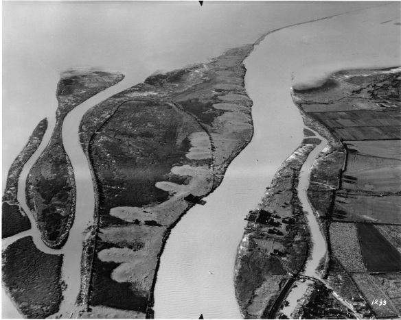
1985 166 12

Iona Island, shown here ca. 1930, is now connected to Sea Island by a causeway and is the home of a large sewage treatment plant and a regional park. The Richmond-Vancouver boundary runs down the middle of the North Arm Channel at the centre of this photo. On the right is Deering Island on the Vancouver side of the channel. City of Richmond Archives photograph 1985 166 12.

Woods Island – This island, located on the north side of Sea Island, is the present day home of McDonald Beach Park with its boat launch, picnic areas and off leash dog park and is hardly a separate island anymore.

1935 Aerial Mosaic of Richmond dtl3

This detail from the 1935 Aerial Mosaic shows the islands surrounding Sea Island. In the North Arm, left to right, are Iona Island, Wood’s Island (tucked in close to the north shore of Sea Island) and Richmond Island, close to the Vancouver side of the channel. In the Middle Arm, left to right, are Swishwash Island, Dinsmore and Pheasant Islands and Duck Island, where the North and Middle Arms join. City of Richmond Archives image.

Richmond Island – Also known as Jimmy’s Island, Richmond Island was the home of the Richmond Cannery from 1882 until around 1909. The island was also home to a hermit, a black man named Jimmy, who might have lived in one of the abandoned cannery buildings. Early Geological maps also indicate that the island was farmed, divided into four lots protected by dykes. Today the island is home to a marina and boatyard as well as a bar and grill. Richmond island is only accessible from the Vancouver side of the river via West 75th Avenue and Bently Street, across a causeway.

~

The next three islands were once separate, but have all been joined and form what is now known as Mitchell Island. These islands were all named for the early pioneers who settled or farmed them.

1935 Aerial Mosaic of Richmond dtl1

This detail shows the three islands which make up the present Mitchell Island, left to right, Eburne Island, Twigg Island and Mitchell Island. City of Richmond Archives image.

Eburne Island – Eburne Island was named for Harry Eburne who lived there for a period of time. Mr. Eburne also gave his name to the community which grew up on both sides of the bridge to Sea Island. The island was also known as Anderson Island.

Twigg Island – Twigg Island was also farmed by it’s namesake J.J.C. Twigg.  Mr. Twigg served as a Richmond Councillor in 1905 and 1906. Twigg Island once joined the two spans of the Fraser Street Bridge which connected Fraser Street in Vancouver to No,5 Road in Richmond.

Mitchell Island – Named for Richmond pioneer Alexander Mitchell, this island is the largest of the three which now form a single large island in the North Arm. A large island with a lot of industrial activity on it, it is accessible using the Knight Street Bridge.

~

Tree Island – Probably named because of the trees which covered it, Tree Island is located in the North Arm just west of the border with Queensborough. The island is more of a peninsula now, infilled at its east end and connected to Lulu Island, but retains its name due to its occupation by the Tree Island Steel Company which has been in operation there for more than 50 years.

1983 6 78TreeIsland

Tree Island, shown here ca. 1960, is the location of the Tree Island Steel Co. and is now more of a peninsula of Lulu Island than a separate Island. City of Richmond Archives photograph 1983 6 78.


The Middle Arm

Swishwash Island – Little more than a tidal marsh, in the late 1880s Swishwash Island became the location of the Sea Island Cannery which burned to the ground in 1899. It was owned and operated by Alexander Ewen and Daniel Munn and pilings from the cannery can still be seen. Dredging spoil enlarged and raised the island to its present state in the 1950s. BC Packers owned Swishwash for many years and donated it to the Nature Conservancy of Canada when the company divested its fishing industry properties.

1997 5 9

At the lower right in this aerial photo, part of Swishwash Island is visible with the pilings of the Sea Island Cannery visible at its tip. Dinsmore and Pheasant Islands are also visible in the channel to the right of the houses of Burkeville. City of Richmond Archives photograph 1997 5 9.

Dinsmore Island – Dinsmore Island, also known as Brough Island, was located in the Middle Arm off the southeast corner of Sea Island. It was named for pioneer John Dinsmore who farmed the island and was an owner of the Dinsmore Island Cannery. The cannery was built in 1894 and was demolished in 1913. The Island was farmed for many years by several owners but by 1952 had become a part of Sea Island due to infilling of the channel. The name is remembered in the Dinsmore Bridge which connects Lulu Island to Sea Island via Gilbert Road, the north end of which sets down on the former island.

1984 17 84 Burkeville

This aerial view of Burkeville, ca. 1944, also shows Pheasant Island and Dinsmore Island connected to Sea Island by a bridge. Both Islands were farmed during their history. City of Richmond Archives photograph 1984 17 84.

Pheasant Island – Pheasant Island was a small island which was just off the north end of Dinsmore Island. Also used as farmland, it was absorbed by Dinsmore Island by channel infilling and thence into Sea Island.

Duck Island – (Middle Arm) – One of two islands inside the Municipality with the name, Duck Island was located between Lulu and Sea Islands at the north end of the Middle Arm of the river. The bridge to Sea Island passed over the island whose channel was used for log storage, wood processing mills being located nearby. A failed attempt to rezone Duck Island as parkland was made in the 1950s after it was approved for dredging spoil disposal. By 1972 the island had been absorbed by Lulu Island and is the present location of the Richmond Night market, a parking lot and the parkade for the River Rock Casino Resort. The last vestige of the island can be seen in the small slough and marsh area near the casino which once formed part of the Duck Island Channel.

2001 26

Duck Island is shown here, ca. 1919, supported part of the bridge to Eburne on Sea Island. Its channel was used as a log storage pond. The island has been completely absorbed into Lulu Island. City of Richmond Archives Accession 2001 26.


The South Arm

Don Island – Also known as Oikawa Island, Don Island is located in the South Arm of the river west of Annacis Island. It was settled, as was Lion Island, in 1902 by a group of Japanese fishermen and their families, led by entrepreneur Jinsaburo Oikawa,  who supplied fish to and worked at the Ewen Cannery.

Lion Island – Also known as Sato Island, Lion Island was the location of Alexander Ewen’s Cannery, for many years the largest on the Fraser River. The cannery, built in 1876, made “Lion Brand” salmon well known around the British Empire. The cannery closed in 1930, but Lion and Don Islands remained inhabited until the last of the Japanese families were removed in the 1942 internment.
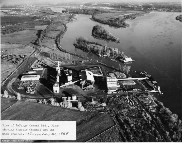
2010 87 31

This aerial view from 1959 shows Lion and Don Islands in the Annacis Island Channel. The Ewen Cannery can be seen on the tip of Lion Island. City of Richmond Archives photograph 2010 87 31.

Whitworth Island – Also known as Gilmore Island, Whitworth Island is separated from Lulu Island by Finn Slough.

~

The next eight islands are located in what is known as the Ladner Reach of the South Arm of the Fraser River. All formed by alluvial deposits from the river, they have been affected by the erection of the Woodward Training Wall, which directs the flow of the river to stabilize the south bank, and by the dyking and farming of some of them. The islands fall within the Agricultural Land Reserve and are under the administration of the BC Ministry of Environment as the South Arm Marshes Wildlife Management Area.

1935 Aerial Mosaic of Richmond dtl2

This detail from the 1935 Aerial Mosaic shows Richmond’s islands in the Ladner Reach. On the right (marked) is Kirkland Island with Rose Island to its left. Rose Island is connected to No.1 Island by the white line of the Woodward Dam which continues down the channel as the Woodward Training wall, through Woodward’s Island. South of Kirkland Island is Williamson Island, then Gunn Island and in the most southerly part of the channel is Barber Island. South of Rose Island is Frenchie’s Island and Duck Island. City of Richmond Archives image.

Kirkland Island – Kirkland Island, named for Ladner resident John Kirkland, is a tidal marsh in the South Arm of the river, owned by the Nature Trust of British Columbia. The island has been dyked and farmed for many years.

Rose Island – Also conserved by the Nature Trust, Rose Island had been dyked and farmed. The channel between Rose and Kirkland Islands has filled in to the point that the two islands are often called Rose-Kirkland Island.

Williamson Island – Williamson Island is a small island south of Kirkland which is also conserved by the Nature Trust. It has been dyked and farmed,

Gunn Island – Another island which was dyked and is farmed, Gunn Island is south of Williamson Island.

Frenchie’s Island – A small privately owned island, Frenchie’s Island is located between Rose and Duck Islands.

Duck Island – (South Arm) – The second island with the name, Duck Island is west of Gunn Island and roughly in the centre of the estuary. An old cannery was located on the island and the pilings can still be seen.

Barber Island – Named for Alfred and Charles Barber, who acquired the island in 1888, Barber Island is the most southerly of Richmond’s islands in the estuary.

No.1 Island – This is a very small island north of Duck Island. The Woodward Dam, part of the Woodward Training Wall, spans the channel between No.1 Island and Rose Island and then runs from No.1 along Woodward’s Island for a distance of 3.7 km.

Woodward’s Island – Named for Nathan and Daniel Woodward who owned the island. Woodward’s Island is the most westerly of Richmond’s South Arm estuary islands.

~

Steveston Island – Originally no more than a sand bar, Steveston Island, also known as Shady Island, was formed by the dumping of dredging spoil and the erection of training structures in the river. It protects the Steveston waterfront. (For more about Steveston Island see https://richmondarchives.ca/2017/03/30/shady-island/)

1988 10 136

Probably the last of Richmond’s Islands to be formed, Steveston (Shady) Island was not much more than a semi-submerged sandbar before dredging spoil and river training devices added to its growth. City of Richmond Archives photo 1988 10 136.

Richmond’s original 26 islands have been reduced due to infilling to 19 which, arguably, could still be referred to as islands, still a respectable amount and more than enough for Richmond to qualify as an “Island City by Nature” and a “Child of the Fraser”.
 

Shady Island – Man-Made by Nature

One of the best loved features of the Steveston waterfront, Steveston Island, known as Shady Island to locals, is something rare in an urban landscape, an untouched, undeveloped piece of natural land. Home to rare species of plants and many types of birds, the island was little more than a sandbar as far back as the 1920s. Rivers are natural island builders and the Fraser would have formed the island on its own but the process was accelerated by the interference of man, leading to the treed sanctuary we see today.

2004 40 1

In this image of the Steveston Waterfront from 1889 no island protects the waterfront. City of Richmond Archives, photograph # 2004 40 1.

In Steveston’s early days, a naturally formed sandbar protected the waterfront by diverting some of the river’s water away from shore. A natural, protected channel formed behind the bar, suitable for the moorage of fishing boats and the construction of canneries.

001

A 1921 map based on a Dept. of Mines geographical survey shows the natural shape of Steveston/Shady Island at the time. A small, permanently dry island near the end of No.2 Road existed, along with a couple of small bars that showed at low tide. A submerged bar extended as far as No.1 Road. City of Richmond Archives, Reference Files.

As European immigration increased, swelling New Westminster’s population and increasing the size and amount of traffic on the river, it was necessary to keep the main river channel navigable by regular dredging. Spoils from dredging were dumped on the Steveston bar forming two distinct parts which were exposed at low tide and were connected by the submerged part of the bar. At high tide, smaller boats could still be taken across that part of the bar, although the route became closed after further dredging and natural build-up closed the gap.

002

By 1947 the addition of wing dams and dredging spoils have begun the process of building the island we know today. City of Richmond Archives, Reference Files.

In the 1930s two wing dams were built on the south side of the island to keep sand from being washed back into the channel. Later, a long training wall was built just upstream. The effect of the wing dams and training wall were to divert the river’s water toward the main channel, increasing its rate of flow and helping to keep the channel clear. This also increased the rate of natural silt build-up on the island. The island now had an important function other than a place to deposit dredging spoils. It formed a well protected harbour along the Steveston waterfront.

1977 1 14

The island before the installation of the rock dam or the breakwater. The western end of the island is still little more than a sandbar. City of Richmond Archives, photograph # 1977 1 14.

In order to to prevent the infill of the harbour channel and to provide access to the island for potential moorage facilities, a high rock dam was built across the upstream entrance to the channel. While the dam was effective, it eliminated flow through the channel, allowing effluent from the canneries to settle, creating a foul smelling basin that infiltrated the whole area with the stench of rotting fish. Within two years the top part of the dam was removed, allowing the channel to flush with each high tide.

1977 1 15

The rock breakwater can be seen in this image, shortly after its completion, ca. 1953. Also visible are the wing dams and the rock dam at the east end of the channel. City of Richmond Archives, photograph # 1977 1 15.

The island’s form was further changed when a long rock breakwater was built. It extends along the length of the island like a spine and gives it the geographical profile it has today.

1988 10 136

This image looking west over Steveston Island, ca. 1976, shows the two wing dams on the left, the training wall at bottom and the rock dam at the entrance to the channel. The photo shows how water can flow through the channel at high tide, flushing clean water through while preventing silt from entering. The end of the rock breakwater, now mostly buried, can be seen extending past the western tip of the island. City of Richmond Archives, photograph # 1988 10 136.

Steveston Island today is a gem on the waterfront of the village. Having resisted development proposals that have arisen over the years, it remains undomesticated and accessible only at low tide across the rock dam, a fact that many people learn each year when they lose track of time and are stranded by the incoming tide. As other parts of Steveston and Richmond change under the pressure of development, let’s hope this little piece of man made nature remains the same.

What’s in a Name – Minoru Park

An oasis in Richmond’s City Centre, Minoru Park is home to a wide range of recreational and cultural facilities. Areas set up for a variety of field sports, a walking and running track, ice rinks and swimming pools, as well as museums, a library, archives, spaces for arts and crafts, senior’s facilities, etc. make the park a popular and well used part of life in our city. With the Japanese origin of the name Minoru, one might think that it connects to Richmond’s history of Japanese immigration, but in fact, the name comes to us from across the Atlantic Ocean.

Eida family-1

The Eida Family, clockwise from left, Tassa, Charlie, Claire, Kaiji and Minoru. (City of Richmond Archives photograph 2009 23)

Between 1906 and 1910, Colonel William Hall Walker, a wealthy Scotsman, was having a Japanese garden built at his estate, the Tully Stud near Kildare in Ireland. The gardens were laid out and built by Japanese master gardener Tassa Eida, who did such a magnificent job that the gardens remain a popular tourist attraction today. A successful breeder of race horses, Walker named one of his colts Minoru after the son of his gardener. In 1907, Col. Walker leased a half-dozen yearlings to King Edward VII, including Minoru.

The horse Minoru had a profitable career in the King’s colours, winning at Epsom as a two-year-old and, ridden by jockey Bertie Jones, winning the Greenham Stakes and the 2000 Guineas as a three-year-old. His greatest triumph was in winning the 1909 Epsom Derby for the King, the first time a reigning monarch had won the coveted prize. The horse came in fourth at the Doncaster St.Leger Stakes, missing a chance to win the British Triple Crown. Two more wins that year finished his year with five wins in seven starts.

2014 26 1

King Edward VII (R) with Minoru after winning the Epsom Derby in 1909. Bertie Jones is the jockey. (City of Richmond Archives photograph 2014 26 1)

In Richmond in 1909 a group of businessmen, Messrs. H. & T. Springer, Suckling, Lewis and Marpole, were building the Township’s first thoroughbred horseracing track on land they had purchased from Samuel Brighouse. In 90 days a mile-long oval, a grandstand, a clubhouse and a mile of barns were built at a cost of $75,000. In choosing a name for the track, they settled on the name of the horse that had just won the Derby for the King and Minoru Park Racetrack was born. Opening day at Minoru Park was attended by 7000 race fans.

2001 09 24

The Minoru Park Racetrack grandstand and clubhouse in 1909. (City of Richmond Archives photograph 2001 9 24)

The track was used for many events in addition to horse racing. Minoru Park was used as a landing strip for aircraft, and was the location of the first flight by an airplane in Western Canada on March 25, 1910, the starting point for the first flight across the Rocky Mountains and the venue for air shows hosted by the Aerial League of Canada.

1978 15 18

On March 25, 1910 Mr. Charles K. Hamilton made the first aircraft flight in Western Canada, taking off in front of 3500 spectators at Minoru Racetrack. (City of Richmond Archives photograph 1978 15 18)

Automobile racing exhibitions were also held at the track, hosting well-known drivers like Barney Oldfield, Bob Burman and “Terrible” Teddy Tetzlaff and cars like the famous “Blitzen Benz” and the “Romano Special”. Polo matches were held in the middle of the track, temporary boxing rings were set up for fans of the pugilistic arts and community events, such as May Day celebrations, were held there as well.

1984 17 69

Racing driver Harry Hooper in the “Vulcan Kewpie” Stutz, accompanied by silent film star Priscilla Dean, raced against an airplane piloted by Lieut. G.K. Trim at Minoru in an event hosted by the Aerial League of Canada on Dominion Day, 1919. The event included lots of aerial stunts and wing walking. A house was erected in the middle of the track so it could be blown up by bombs dropped from aircraft, but exploded on its own, much to the amusement of the crowd. (City of Richmond Archives photograph 1984 17 69)

With the outbreak of World War I in 1914, Minoru Park closed until 1920 when it reopened and was renamed Brighouse Park. Brighouse Park Racetrack operated until 1941 when it closed for racing permanently, although it continued to be used as a training and boarding facility. The land was purchased by the British Columbia Turf and Country Club in 1945 and in 1958 the Municipality of Richmond purchased the property. The park reclaimed the name Minoru in 1960 to honour the long history of horse racing at the site. In 1962 the Mayor and Council purchased the Brighouse Estate, allowing the park to expand to its present size and develop into today’s complex of recreational parkland, buildings and services, a complex which is presently being upgraded with the construction of a new aquatic centre, sports facility and seniors facility.

This 1951 aerial view over the intersection of Granville Avenue and No.3 Road shows Brighouse (Minoru) Racetrack while under the ownership of the BC Turf and Country Club. Richmond Municipal Hall is on the corner in the same location as City Hall Today. (City of Richmond Archives photograph 1984 17 5)

This 1951 aerial view over the intersection of Granville Avenue and No.3 Road shows Brighouse (Minoru) Racetrack while under the ownership of the BC Turf and Country Club. Richmond Municipal Hall is on the corner in the same location as City Hall Today. (City of Richmond Archives photograph 1984 17 5)

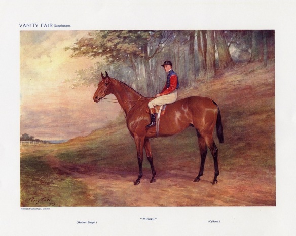
Minoru the racehorse was retired to the Tully Stud in 1910 and in 1913 was sold to a Russian stud farm. The horse’s history after that is lost in the chaos of the Russian Revolution, although stories are told of Minoru being shot by an English officer to prevent him being abused by the Bolsheviks, or of a possible escape across Ukraine and Russia to the Black Sea and by ship to Turkey.

A print of Minoru from Vanity Fair, 1909. (City of Richmond Archives accession 2009 23)

A print of Minoru from Vanity Fair, 1909. (City of Richmond Archives accession 2009 23)

In 2009, in commemoration of the 100th Anniversary of the opening of Minoru Park, a bronze statue of Minoru was unveiled near the Richmond Cultural Centre. Created by artist Sergei Traschenko and donated to the City of Richmond by the Milan & Maureen Ilich Foundation, the statue was dedicated to the winning spirit of Richmond’s early pioneers of both Eastern and Western cultures and the men and women of the early thoroughbred racing industry in Richmond. The unveiling event was attended by many citizens and dignitaries, including Brian Eida, the son of Minoru (Jack) Eida who gave his name to a horse, which gave its name to a racetrack, which gave its name to a park.

The bronze statue of Minoru in Minoru Park. (City of Richmond Archives photograph)

The bronze statue of Minoru in Minoru Park. (City of Richmond Archives photograph)


Focus on the Record – Records of Early Parks and Recreational Facilities

The establishment of a Recreation Commission in 1954 and the subsequent incorporation of parks and recreation services into the administrative structure of municipal government under the direction of the Parks and Recreation Commission resulted in the rapid growth of recreational land, facilities, and services in Richmond.

Little League Tournament at Brighouse Park, 1961.

Little League Tournament at Brighouse Park, 1961. City of Richmond Archives Photograph 1978 33 28

Prior to the establishment of the Commission, just over 20 acres of land in the municipality was parkland, much of which was maintained by local community associations and groups.  The Parks and Recreation Commission was initially established composed of elected members of both Council and School Board, which allowed for the coordinated development of school playing fields and municipal parks, simplified the planning of their locations, and reduced duplication of services.

Deed of Land. Purchase of part of present-day Minoru Park, 1958. City of Richmond Archives MR 66, File 1540

Deed of Land. Purchase of part of present-day Minoru Park, 1958. City of Richmond Archives MR 66, File 1540

In 1958, major plans and projects came to fruition under the direction of the Commission, the most significant being the purchase of land from BC Turf and Country Club, the owners of the Brighouse Park Race Track.  That land, first known as Centennial Park, is the southern part of what is now Minoru Park.  By 1959, Centennial Pool, Richmond’s first swimming pool, had been opened on the site.

Swim meet at Centennial Pool, 1963. City of Richmond Archives Photograph 1985 77 26

Swim meet at Centennial Pool, 1963. City of Richmond Archives Photograph 1985 77 26

Development there continued through the 1960s with the installation of a track, the building of a pavilion, arena, arts centre and library.

Opening of Minoru Sports Pavilion, 1964. City of Richmond Archives Photograph 1978 32 40

Opening of Minoru Sports Pavilion, 1964. City of Richmond Archives Photograph 1978 32 40

In 1970, the municipality acquired 217 acres for the Richmond Nature Park as the first of many new parks and community centre projects in that decade.

Aerial view of Richmond Nature Park, 1977. City of Richmond Archives Photograph 1978 41 5

Aerial view of Richmond Nature Park, 1977. City of Richmond Archives Photograph 1978 41 5

The City of Richmond Archives holds records documenting the growth of recreational opportunities in Richmond, including minutes of the Parks and Recreation Commission, bylaws and bylaw files relating to park acquisition and the building and maintenance of facilities, administrative and operational records of the early Recreation Department and the later Leisure Services Department, records of the Richmond School Board, and records of community associations and cultural and sports groups affiliated with the Commission.

[Note – this is an updated version of an article first published in the Spring 2014 issue of the Archives News]