
2017 marks the 150th Anniversary of Canadian Confederation, a time span which parallels the history of non-First Nations settlement in what is now Richmond. Shown in this post are images from the City of Richmond Archives from each of the 15 decades from the 1860s to the present.
1867 to 1877
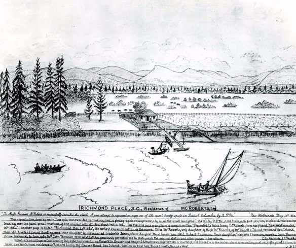
Hugh McRoberts is generally acknowledged to have been the first European settler in what is now Richmond. This image, from an original pencil sketch done by “R.P.M.” for McRoberts’ daughter Jenny and enhanced by Vancouver Archivist Maj. J.S. Matthews, shows a representation of the McRoberts farm on Sea Island in 1862. The album with the sketch contains the earliest known use of the name Richmond. Hugh McRoberts lived in the house until 1873, expanding his farm to cover nearly half of Sea Island. (City of Richmond Archives photograph 1977 3 4)
Starting with Hugh McRoberts there began a slow but steady migration of farmers to Lulu and Sea Islands. The settlement of Lulu Island started on the outside of the island and spread towards the interior due to the low lying, marshy land and peat bogs. Early settlers used the network of sloughs as transportation routes. In 1871 British Columbia entered Confederation and became a Province of Canada.
1877 to 1887

The Municipality of Richmond was incorporated on November 10, 1879. The first council meetings were held in the house of Hugh Boyd but by 1881 our fledgling municipality’s first town hall was opened. Shown here ca. 1888, the building was erected at a cost of $488. It was also used as a school, as shown in this image. Posing for the photo are William Garratt, Leo Carscallen, Peter Carscallen, James Sexsmith, Mr. McKinney, Jack Smith, George Sexsmith, William Mellis, Frances Sexsmith, Anna Sexsmith, Pearl Robinson, Kate Smith, Grace Sweet, Mae Vermilyea and Anna Noble. (City of Richmond Archives photograph 1984 17 77)
Richmond continued to grow over the next decade as more people acquired land and homesteaded. Many pioneer families arrived during this time period, and in 1879 a group of them petitioned the BC Government to incorporate the area as the Municipality of Richmond. On November 10, 1879 the Municipality was incorporated and began the process of organizing road construction and dyking and drainage, now paid for by the collection of taxes. A new Town Hall was built on land which now forms the corner of Cambie and River Roads and the first school district was formed, with the Town Hall acting as the schoolhouse. In 1882 the first cannery was built in Steveston beginning our long fishing industry heritage. In 1885 the Letters Patent from 1879 were revoked and new ones issued to incorporate the Corporation of the Township of Richmond, redrawing the municipal boundaries to include all the islands in the North and South Arms of the Fraser River and ceding Queensborough to New Westminster.
1887 to 1897

The first bridge to Richmond was built in 1889. The Marpole Bridge was actually two spans, one across the North Arm between Marpole and Sea Island and the other from Sea Island to Lulu Island. This image shows a crew of bridge builders and painters posing on the North Arm section, ca. 1888. (City of Richmond Archives photograph 1977 2 1)
By 1887 Richmond’s population had grown to 200-300 people. In 1889 the first North Arm bridge was built to Richmond, from Eburne on the Vancouver side of the River to Sea Island and then a second span to Lulu Island. For the first time there was a route to and from Richmond that did not involve getting in a boat, at least while the bridge was in service and not closed to allow for shipping traffic or suffering damage from a collision by shipping or ice. Communities developed in Steveston, London’s Landing and Eburne. Japanese immigration was underway, filling labour needs in the fishing industry. The first police constable was employed by the Municipality.
1897 to 1907
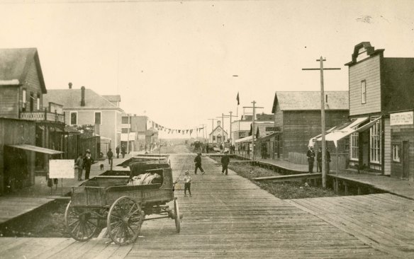
Steveston was booming in the 1890’s when this image was taken (either 1891 or 1895). Stores, hotels and other services catering to workers in the fishing industry made for a vibrant business district and encouraged more people to settle in the area. The sign displayed on the left in this photo advertises town lots for sale by auction at the opera house at 2PM. (City of Richmond Archives photograph 1984 17 75)
By 1897 there were 23 canneries operating on the Fraser River in Richmond. The agricultural industry was performing well too with Richmond acting as the lower mainland’s breadbasket, providing vegetables, produce , dairy and beef products to the growing cities across the river. Into this successful mix came the BC Electric Railway Co. in 1905, providing fast and efficient freight and passenger service from Vancouver to Steveston.

The B.C. Elelctric Railway Company Interurban Tram provided an efficient, regular service to Vancouver for freight and passengers. Eventually there were 20 stations on Lulu Island servicing residents and businesses. The tram ran for more than 50 years. (City of Richmond Archives photograph 1978 12 8)
1907 to 1917

In 1909 Minoru Park Racetrack was opened making Richmond a destination for horse racing fans. The track had its own railroad siding and special trams operated on race days bringing in thousands of people for the events. (City of Richmond Archives photograph 2001 9 24)
In 1909, the opening of Minoru Park Racetrack made Richmond a popular destination for race fans. Named for King Edward VII’s Epsom Derby winning horse the track had its own siding on the BC Electric Railway’s Interurban Tram line with thousands of people travelling to Richmond for races and creating a new income stream for the city and entrepreneurs. The track also became a centre for aviation in the Lower Mainland, being the location of the first flight of an airplane in Western Canada, the starting point of the first flight over the Rockies, etc.
Richmond’s population continued to grow and by 1914 the Bridgeport area was home to a flour mill, a shinglemill, an iron bar mill, the Dominion Safe Works, a sawmill and many residents. The advent of World War I in 1914 put the nation and Richmond on a war footing and while industries important to the war effort grew, Minoru Park was closed until after the war. Many young men left Richmond to join the battle, 25 were never to return.
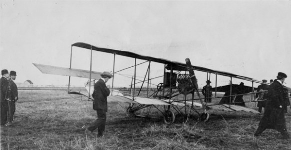
On March 25, 1910 Charles K. Hamilton made the first airplane flight in Western Canada at Minoru Park Racetrack, starting Richmond’s long association with flight. (City of Richmond Archives photograph 1978 15 18)
1917 to 1927

The 1918 Steveston fire devastated the fishing town. Shown here is some of the destruction with the burned out shell of the Hepworth Block at centre. Buildings on the north side of Moncton Street were saved. (City of Richmond Archives photograph 1978 5 2)
On May 14, 1918 Steveston burned. There had been fires before but the 1918 fire resulted in the loss of most of the buildings between No. 1 Road and 3rd. Ave. south of Moncton St., including three canneries, three hotels and numerous businesses. Approximately 600 Japanese, Chinese and First Nations workers were made homeless. Total damages amounted to $500,000.
After the end of the World War I life returned to normal in Richmond. In 1920 a new Town Hall was built at the corner of Granville Avenue and No.3 Road, replacing the original one which had burned in 1912. The racetrack also reopened in 1920 with a new name. Now known as Brighouse Park Racetrack it was joined by Lansdowne Park Racetrack in 1924. The opening of the second racetrack in Richmond allowed double the amount of races to be held and still stay within the restrictions placed on the racing industry by the BC Government.

Richmond’s new Town Hall opened in 1920 on property next to Brighouse Park Racetrack which reopened in 1920 after the end of the war. (City of Richmond Archives photograph 1987 97 1)
1927 to 1937

The program for the official opening of the Vancouver Airport on Sea Island in July of 1931. (City of Richmond reference files)
In 1929, in a farmer’s field just north of Lansdowne Park Racetrack, BC’s second licenced airfield opened. The Vancouver Airport was a temporary construction consisting of a grass field with some structures, hangars and a terminal building close to the Alexandra Road Interurban station. It was replaced in 1931 by the modern new Vancouver Airport on Sea Island.
The Richmond Review published its first newspaper on April 1, 1932. The paper would continue to publish “in the interests of Richmond and community” until its demise in 2015. The Great Depression was well underway when Reeve Rudy Grauer came up with a plan to help people who could not keep up with their property taxes. When back taxes or water bills could not be paid, the land could be sold to the Municipality. As long as the property owner could pay something toward the debt each year the land could not be sold to another owner with the result that not one property was lost due to unpaid taxes in Richmond during the depression.
1937 to 1947

Members of the Steveston Air Raid Protection unit pose here on the fire engine they built in 1943. The unit was the first in Canada. Men have been identified as: (front) Chief William Simpson, (left to right) George Milne, Gul Gollner, Allie McKinney, unidentified, Austin Harris, Bill Glass, Jack Gollner, Milt Yorke and Harry Hing. (City of Richmond Archives photograph 1978 31 57)
This decade was dominated by World War II. The airport on Sea Island was designated for direct military use, including elementary flight training for Air Force Pilots as well as Air Force use. Boeing Canada erected a plant for the construction of patrol bombers for the war effort.

The Boeing Canada Plant on Sea Island produced 362 Consolidated PBY long range patrol bombers, known as Catalinas or Cansos, during the war. (City of Richmond Archives photograph 1985 199 1)
The internment of Japanese Canadians and their removal from the coast in early 1942 changed the face of Richmond, especially in Steveston which lost 80 percent of its population. On Sea Island the community of Burkeville was built to provide housing for workers employed at the Boeing Canada Aircraft plant and their families. Once again young Richmond men signed up for the armed forces and 36 did not come home.
1947 to 1957

Post-war development in Richmond resulted in the growth of commercial buildings in the Brighouse area. Shown here in 1948, the corner of No.3 Road and Granville Avenue shows commercial buildings on the east side of No.3 Road near the Municipal Hall. The BC Electric Railway’s Brighouse Station made access to the area convenient and before long the east side of the street was lined with stores and services. (City of Richmond Archives photograph 1997 16 1)
Post war development saw Richmond’s population grow. The Brighouse area developed into a commercial hub and subdivisions developed to house families moving to the area. Burkeville became part of Richmond, no longer a worker’s housing complex. In order to serve the rising population, theatres, bowling alleys, swimming pools and other entertainment services were built. In 1948 one of the worst floods in memory occurred in the Fraser Valley. While serious damage was done in many areas, Richmond came out well with only one breach of the dyke 100 yards east of the rice mill.
The Broadmoor Subdivision, looking west from No.3 Road in 1953 is only one of many residential areas that came under construction in the 1950s. New building to house Richmond’s rapid population growth boomed through this time whether as Veteran’s Land Act areas or by commercial developers. (City of Richmond Archives photograph 1977 1 59)
1957 to 1967
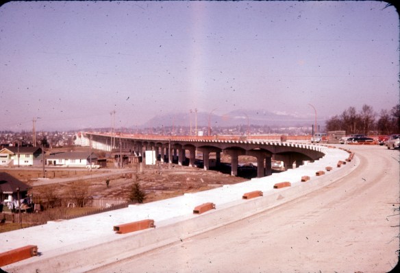
The construction of the Oak Street Bridge in 1957, and later the Deas Island Tunnel had a greater effect on the growth of Richmond’s population than any other event to that date. Now easily accessible from Vancouver and with a direct route to the United States, more people and more businesses moved to Richmond. (City of Richmond Archives photograph 2008 36 2 23)
In 1957 the Oak Street bridge was built giving fast and easy road access to Richmond from Vancouver and making the Municipality even more desirable as a place to live and to start a business. A new City Hall was opened the same year in the same location as the old one. With the new ease of access and bus service expanding all around the region, the BC Electric trams were made redundant and the Marpole to Steveston line saw its last run in 1958.
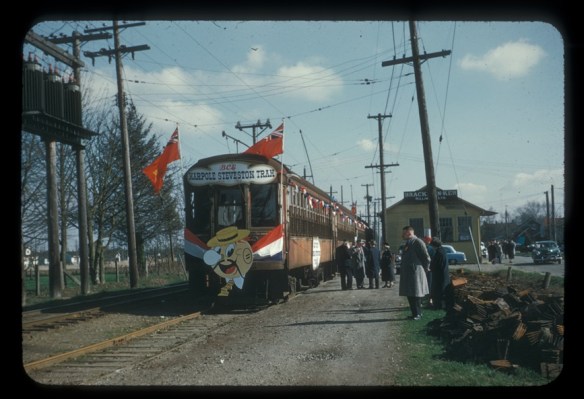
The last run of the Marpole to Steveston tram, shown here at Brighouse Station, happened on February 28, 1958. It was the last Interurban Tram operating in BC. (City of Richmond Archives photograph 1839 Brighouse)
The Municipality purchased the Brighouse Estates in 1962, the deal providing land for Minoru Park, the Richmond Hospital and industrial land. Richmond’s retail options increased in 1964 with the opening of Richmond Square Shopping Centre, built on part of the old Brighouse/Minoru Racetrack. In 1966 the Hudson’s Bay Company announced plans to build a store in Richmond which, in later years, would be joined to Richmond Square and become known as Richmond Centre Mall. The Richmond General Hospital opened on February 26, 1966 providing much needed local care for residents.

The new Richmond Municipal Hall, under construction in the background of this photo, was opened in 1957. The old hall was demolished once the new one was ready to be occupied. (City of Richmond Archives photograph 1997 42 3 47)
1967 to 1977

The Richmond Arts Centre opened in 1967, one of several projects to mark Canada’s 100th Anniversary. (City of Richmond Archives photograph 2004 11)
Canada’s 100th Birthday was in 1967 and like most communities around the country Richmond marked the occasion with commemorative projects. The Richmond Arts Centre was one of these, along with the placement of Minoru Chapel in Minoru Park, and a Pioneers Luncheon. In 1968 the Vancouver International Airport’s new $32 Million terminal opened. In 1972 the first two towers of Richmond’s first high rise development were ready for occupation, the third tower opened in 1973.

Mayor Gil Blair speaks at the groundbreaking ceremony for the new Lansdowne Park Mall. Built on the site of the horse racing track, the mall would open in September 1977. (City of Richmond Archives photograph 2006 7 12)
After much controversy a new shopping mall project was started on the grounds of the old Lansdowne Park Racetrack. Woodwards would be the anchor store for the new Lansdowne park mall. While the newest of Richmond’s retail outlets was under construction its oldest was lost in 1976 when Grauer’s Store shut down after 63 years of service to the community, a victim of airport expansion and bureaucracy.

Richmond’s oldest retail outlet, Grauer’s Store on Sea Island, closed it’s doors forever on May 31, 1976. (City of Richmond Archives photograph 1996 13 5)
1977 to 1987
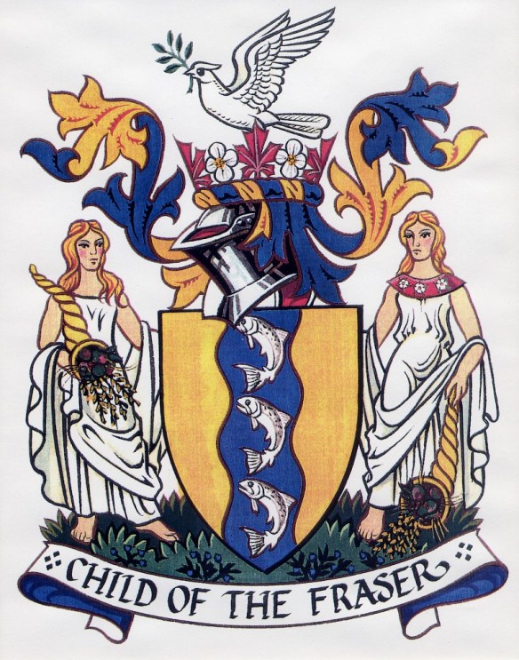
1979 was the 100th Anniversary of the incorporation of Richmond and several projects and celebrations were planned to mark the event. The Corporation of the township of Richmond adopted the “Child of the Fraser” Coat of Arms as its official symbol. (City of Richmond Archives image)
On January 1, 1977 a new street address system was introduced in Richmond with all residents and businesses adding a zero to the end of even numbered address and a one to the end of odd numbered addresses. In 1979 Richmond’s 100th Anniversary was marked by celebrations and commemorative projects including hosting the BC Summer Games, a history book, “Richmond: Child of the Fraser”, and the adoption of a new coat of arms and official seal.
Through this decade Richmond continued its expansion with the construction of hotels, businesses, temples and churches and community buildings such as the Gateway Theatre and Minoru Senior’s Centre. Improvements to other community buildings were made, such as a roof for the Minoru swimming pool and a second ice rink. In 1986, after 20 years of planning, the Alex Fraser Bridge was opened connecting Richmond to Surrey and Delta.
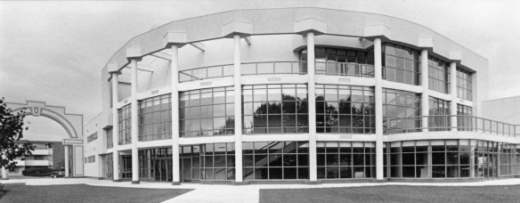
The Gateway Theatre is a mainstay of Richmond’s arts and culture community. It opened on September 19, 1984. (City of Richmond Archives accession 1988 121)
The Municipality purchased the land at Garry Point from the Bell-Irving family in 1981, with the intention to make it a park and to prevent development of the site. The racial demographic of Richmond began to change in the 1980s as an influx of immigrants from Hong Kong began, many making the Municipality their home.
1987 to 1997
Fantasy Garden World opened in Richmond on March 5, 1987. Owned by BC Premier Bill Vander Zalm, the facility operated for many years as a tourist attraction. Work began on a $55 million project to renovate Richmond Square and Richmond Centre malls. The project would result in the joining of the two malls as a new Richmond Centre Mall.

Opened on March 5, 1987 Fantasy Garden World was a Richmond tourist destination, and a catalyst for political controversy. (City of Richmond Archives photograph 2009 16)
In May 1990 Richmond asked the Provincial Government to grant the Municipality status as a City. New Letters Patent were received designating Richmond Municipality, known as “The Corporation of the Township of Richmond”, to be called the “City of Richmond”.
Richmond continued to grow. Ground was broken on Richmond’s new Library and Cultural Centre in 1991, the Riverport area was developed with the construction of the Riverport Ice Rink Complex and the Watermania Aquatic Centre. The Ironwood Mall project was approved. Several Asian style malls were built to serve the rising numbers of immigrants from Hong Kong and Mainland China. The Aberdeen Centre, Yaohan Centre, Parker Place, President’s Plaza and Fairchild Square marketed themselves under the name “Asia West”.

Richmond’s new Minoru Park Plaza and Library and Cultural Centre opened on January 16, 1993. (City of Richmond Archives photograph 2008 39 6 685)
1997 to 2007
Richmond marked the new millennium with the opening of the new City Hall on May 20, 2000.

Richmond City Hall opened on May 20, 2000. It is believed to be the first municipal building in BC to use a Feng Shui consultant in its design. (City of Richmond Archives photograph 2007 7)
In 2002 the Tall Ships came to Steveston resurrecting images of 100 years ago on the waterfront when sailing ships loaded canned salmon. The city continued is growth, cranes becoming a normal sight on the sky line as more and higher buildings were erected.
The River Rock Casino opened on land once occupied by the failed Bridgepoint Market. The facility, with its resort hotel, opened on June 24, 2004. Construction on the largest project to date in Richmond, the Olympic Speed Skating Oval, began in November of 2006.

Construction began on the Olympic Oval in November of 2006. (City of Richmond Archives – B. Phillips photograph)
2007 to 2017
On August 17, 2009 the first passenger rail system since the demise of the BC Electric Interurban line began service in Richmond. The Canada Line rapid transit line connected Richmond City Centre and YVR to Downtown Vancouver.
The big story of 2010 was the Winter Olympic Games. Richmond’s Olympic Oval was a venue for the speed skating events and the community celebration site at Minoru Park, known as the O Zone, was crowded with spectators for concerts, events and to visit the Holland House in Minoru Arenas for a visit or a drink and a meal.

Crowds watch the big screen at the O Zone as Sydney Crosby is interviewed after the winning goal for Canada in the Gold Medal Hockey game. (City of Richmond Archives – W. Borrowman photo)
Richmond’s growth continued through this decade, building increased with highrise construction changing the city skyline dramatically. More shopping centres opened, MacArthur Glen Outlet Mall brought retail back to Sea Island and Central at Garden City had space for a Walmart Supercentre as well as many other merchants. The Railway Greenway was opened, creating a biking and walking corridor along the old Interurban line to Steveston. The Garden City Lands, formerly held by the Department of National Defense, have been purchased by the City and are being transformed into an urban farming area and natural bog land park.
Work has begun on a bridge to replace the Massey Tunnel, now nearing its 60th anniversary, a structure that will increase traffic flow through Lulu Island and may bring more people to live here. The City’s population has exceeded 200,000 and is growing still.
The pioneers who made a living from the boggy soil and running waters of Richmond would have had little concept of the city that has grown in the past fifteen decades. Who knows what the next fifteen will bring?

Pingback: Canadian History Roundup – Week of June 25, 2017 | Unwritten Histories