Richmond is an island city. Built on land created by the action of the Fraser River, our city stands entirely surrounded by flowing waters which continue to deposit land on our shores. Richmond’s boundaries have changed several times over its history but were set in its final configuration in 1934. At that time 26 named islands were included inside our municipal limits. Many were and remain little more than tidal marshes but others became the foundation of today’s city with its agricultural, industrial and residential land.
When Richmond was first incorporated in 1879, its boundaries were defined by the shorelines of Sea and Lulu Islands. This included the Middle Arm and its islands and also the part of Lulu Island which is now Queensborough, part of the City of New Westminster.
In 1885 the Corporation of the Township of Richmond extended its boundaries. They now followed the north shore of the North Arm and included all the islands in it. The southern boundary of Richmond was also extended out into the South Arm of the River adding many of the islands there to the Municipality. At this same time, Queensborough was ceded to New Westminster.
In 1910 the boundaries were moved again when the City of South Vancouver extended its boundaries into the North Arm. The new border extended 200 feet south of the low water mark following the shore and reduced Richmond’s area accordingly.
In 1934 a newly enacted bylaw extended Richmond’s boundaries to include ” all the area, lands, foreshore and lands covered by water” lying within its boundaries. The Richmond Municipal Boundaries Extension Bylaw defined the present limits of our city which includes these islands.

The 1935 Aerial Mosaic of Richmond shows Richmond with all of the 26 islands as they were when the Municipal boundaries were set. City of Richmond Archives image.
Lulu Island – The largest island in the group and home to most of Richmond’s population, industry and agriculture, Lulu Island was named for San Francisco actress, singer and dancer Lulu Sweet, as reported in another posting in this blog. (See https://richmondarchives.ca/2016/09/22/whats-in-a-name-lulu-island/ for more information. ) The island was originally two islands, separated by a channel which flowed northwest from Annacis Island in the South Arm to Mitchell Island in the North Arm. The channel was formed by three large sloughs, the main one being known today as Bath Slough.
Sea Island – Richmond’s second largest island, Sea Island was probably named by Captain George Henry Richards who included the name in charts dating from the 1850s. Acknowledged to be the location of the first European homestead in Richmond, Sea Island was once mostly farm land and home to the small communities of Eburne, Burkeville and the Cora Brown subdivision. The island was also the location of the Vancouver and Acme Canneries and, before the Second World War, a large Japanese community. ( See https://richmondarchives.ca/2015/01/06/japanese-canadians-on-sea-island/ for more.) Selected as the location of the Vancouver Airport, which opened in 1931, the continuing expansion of the facility has resulted in the expropriation of agricultural and residential land on the island. The community of Burkeville is the only remaining population centre and farming has been greatly reduced.
The North Arm
Iona Island – Located at the north west end of Sea Island at the mouth of the North Arm, Iona Island is the present home of the Iona Island Wastewater Treatment Plant and the Iona Beach Regional Park. Once little more than a large sand bar, the island was farmed early in its history. It is connected to Sea island by a causeway and was once considered as a potential location for a ferry terminal.

Iona Island, shown here ca. 1930, is now connected to Sea Island by a causeway and is the home of a large sewage treatment plant and a regional park. The Richmond-Vancouver boundary runs down the middle of the North Arm Channel at the centre of this photo. On the right is Deering Island on the Vancouver side of the channel. City of Richmond Archives photograph 1985 166 12.
Woods Island – This island, located on the north side of Sea Island, is the present day home of McDonald Beach Park with its boat launch, picnic areas and off leash dog park and is hardly a separate island anymore.

This detail from the 1935 Aerial Mosaic shows the islands surrounding Sea Island. In the North Arm, left to right, are Iona Island, Wood’s Island (tucked in close to the north shore of Sea Island) and Richmond Island, close to the Vancouver side of the channel. In the Middle Arm, left to right, are Swishwash Island, Dinsmore and Pheasant Islands and Duck Island, where the North and Middle Arms join. City of Richmond Archives image.
Richmond Island – Also known as Jimmy’s Island, Richmond Island was the home of the Richmond Cannery from 1882 until around 1909. The island was also home to a hermit, a black man named Jimmy, who might have lived in one of the abandoned cannery buildings. Early Geological maps also indicate that the island was farmed, divided into four lots protected by dykes. Today the island is home to a marina and boatyard as well as a bar and grill. Richmond island is only accessible from the Vancouver side of the river via West 75th Avenue and Bently Street, across a causeway.
~
The next three islands were once separate, but have all been joined and form what is now known as Mitchell Island. These islands were all named for the early pioneers who settled or farmed them.

This detail shows the three islands which make up the present Mitchell Island, left to right, Eburne Island, Twigg Island and Mitchell Island. City of Richmond Archives image.
Eburne Island – Eburne Island was named for Harry Eburne who lived there for a period of time. Mr. Eburne also gave his name to the community which grew up on both sides of the bridge to Sea Island. The island was also known as Anderson Island.
Twigg Island – Twigg Island was also farmed by it’s namesake J.J.C. Twigg. Mr. Twigg served as a Richmond Councillor in 1905 and 1906. Twigg Island once joined the two spans of the Fraser Street Bridge which connected Fraser Street in Vancouver to No,5 Road in Richmond.
Mitchell Island – Named for Richmond pioneer Alexander Mitchell, this island is the largest of the three which now form a single large island in the North Arm. A large island with a lot of industrial activity on it, it is accessible using the Knight Street Bridge.
~
Tree Island – Probably named because of the trees which covered it, Tree Island is located in the North Arm just west of the border with Queensborough. The island is more of a peninsula now, infilled at its east end and connected to Lulu Island, but retains its name due to its occupation by the Tree Island Steel Company which has been in operation there for more than 50 years.

Tree Island, shown here ca. 1960, is the location of the Tree Island Steel Co. and is now more of a peninsula of Lulu Island than a separate Island. City of Richmond Archives photograph 1983 6 78.
The Middle Arm
Swishwash Island – Little more than a tidal marsh, in the late 1880s Swishwash Island became the location of the Sea Island Cannery which burned to the ground in 1899. It was owned and operated by Alexander Ewen and Daniel Munn and pilings from the cannery can still be seen. Dredging spoil enlarged and raised the island to its present state in the 1950s. BC Packers owned Swishwash for many years and donated it to the Nature Conservancy of Canada when the company divested its fishing industry properties.

At the lower right in this aerial photo, part of Swishwash Island is visible with the pilings of the Sea Island Cannery visible at its tip. Dinsmore and Pheasant Islands are also visible in the channel to the right of the houses of Burkeville. City of Richmond Archives photograph 1997 5 9.
Dinsmore Island – Dinsmore Island, also known as Brough Island, was located in the Middle Arm off the southeast corner of Sea Island. It was named for pioneer John Dinsmore who farmed the island and was an owner of the Dinsmore Island Cannery. The cannery was built in 1894 and was demolished in 1913. The Island was farmed for many years by several owners but by 1952 had become a part of Sea Island due to infilling of the channel. The name is remembered in the Dinsmore Bridge which connects Lulu Island to Sea Island via Gilbert Road, the north end of which sets down on the former island.

This aerial view of Burkeville, ca. 1944, also shows Pheasant Island and Dinsmore Island connected to Sea Island by a bridge. Both Islands were farmed during their history. City of Richmond Archives photograph 1984 17 84.
Pheasant Island – Pheasant Island was a small island which was just off the north end of Dinsmore Island. Also used as farmland, it was absorbed by Dinsmore Island by channel infilling and thence into Sea Island.
Duck Island – (Middle Arm) – One of two islands inside the Municipality with the name, Duck Island was located between Lulu and Sea Islands at the north end of the Middle Arm of the river. The bridge to Sea Island passed over the island whose channel was used for log storage, wood processing mills being located nearby. A failed attempt to rezone Duck Island as parkland was made in the 1950s after it was approved for dredging spoil disposal. By 1972 the island had been absorbed by Lulu Island and is the present location of the Richmond Night market, a parking lot and the parkade for the River Rock Casino Resort. The last vestige of the island can be seen in the small slough and marsh area near the casino which once formed part of the Duck Island Channel.

Duck Island is shown here, ca. 1919, supported part of the bridge to Eburne on Sea Island. Its channel was used as a log storage pond. The island has been completely absorbed into Lulu Island. City of Richmond Archives Accession 2001 26.
The South Arm
Don Island – Also known as Oikawa Island, Don Island is located in the South Arm of the river west of Annacis Island. It was settled, as was Lion Island, in 1902 by a group of Japanese fishermen and their families, led by entrepreneur Jinsaburo Oikawa, who supplied fish to and worked at the Ewen Cannery.
Lion Island – Also known as Sato Island, Lion Island was the location of Alexander Ewen’s Cannery, for many years the largest on the Fraser River. The cannery, built in 1876, made “Lion Brand” salmon well known around the British Empire. The cannery closed in 1930, but Lion and Don Islands remained inhabited until the last of the Japanese families were removed in the 1942 internment.

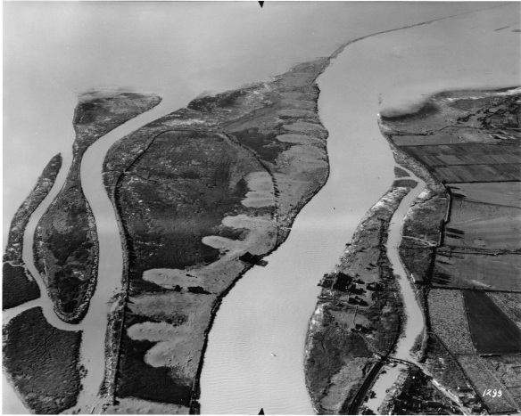
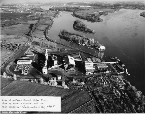
This aerial view from 1959 shows Lion and Don Islands in the Annacis Island Channel. The Ewen Cannery can be seen on the tip of Lion Island. City of Richmond Archives photograph 2010 87 31.
Whitworth Island – Also known as Gilmore Island, Whitworth Island is separated from Lulu Island by Finn Slough.
~
The next eight islands are located in what is known as the Ladner Reach of the South Arm of the Fraser River. All formed by alluvial deposits from the river, they have been affected by the erection of the Woodward Training Wall, which directs the flow of the river to stabilize the south bank, and by the dyking and farming of some of them. The islands fall within the Agricultural Land Reserve and are under the administration of the BC Ministry of Environment as the South Arm Marshes Wildlife Management Area.

This detail from the 1935 Aerial Mosaic shows Richmond’s islands in the Ladner Reach. On the right (marked) is Kirkland Island with Rose Island to its left. Rose Island is connected to No.1 Island by the white line of the Woodward Dam which continues down the channel as the Woodward Training wall, through Woodward’s Island. South of Kirkland Island is Williamson Island, then Gunn Island and in the most southerly part of the channel is Barber Island. South of Rose Island is Frenchie’s Island and Duck Island. City of Richmond Archives image.
Kirkland Island – Kirkland Island, named for Ladner resident John Kirkland, is a tidal marsh in the South Arm of the river, owned by the Nature Trust of British Columbia. The island has been dyked and farmed for many years.
Rose Island – Also conserved by the Nature Trust, Rose Island had been dyked and farmed. The channel between Rose and Kirkland Islands has filled in to the point that the two islands are often called Rose-Kirkland Island.
Williamson Island – Williamson Island is a small island south of Kirkland which is also conserved by the Nature Trust. It has been dyked and farmed,
Gunn Island – Another island which was dyked and is farmed, Gunn Island is south of Williamson Island.
Frenchie’s Island – A small privately owned island, Frenchie’s Island is located between Rose and Duck Islands.
Duck Island – (South Arm) – The second island with the name, Duck Island is west of Gunn Island and roughly in the centre of the estuary. An old cannery was located on the island and the pilings can still be seen.
Barber Island – Named for Alfred and Charles Barber, who acquired the island in 1888, Barber Island is the most southerly of Richmond’s islands in the estuary.
No.1 Island – This is a very small island north of Duck Island. The Woodward Dam, part of the Woodward Training Wall, spans the channel between No.1 Island and Rose Island and then runs from No.1 along Woodward’s Island for a distance of 3.7 km.
Woodward’s Island – Named for Nathan and Daniel Woodward who owned the island. Woodward’s Island is the most westerly of Richmond’s South Arm estuary islands.
~
Steveston Island – Originally no more than a sand bar, Steveston Island, also known as Shady Island, was formed by the dumping of dredging spoil and the erection of training structures in the river. It protects the Steveston waterfront. (For more about Steveston Island see https://richmondarchives.ca/2017/03/30/shady-island/)

Probably the last of Richmond’s Islands to be formed, Steveston (Shady) Island was not much more than a semi-submerged sandbar before dredging spoil and river training devices added to its growth. City of Richmond Archives photo 1988 10 136.
Richmond’s original 26 islands have been reduced due to infilling to 19 which, arguably, could still be referred to as islands, still a respectable amount and more than enough for Richmond to qualify as an “Island City by Nature” and a “Child of the Fraser”.

Pingback: Canadian History Roundup – Week of April 30, 2017 | Unwritten Histories