Focus on the Record – The Eric Rathborne fonds.

The Eric Rathborne fonds at the City of Richmond Archives consists mainly of black and white photographs of aviation activities at the newly opened Vancouver Airport on Sea Island, taken ca. 1935 to 1960.

1997 5 5 This aerial view of Vancouver Airport shows the hangars, administration building and radio building, ca. 1939. City of Richmond Archives photograph 1997 5 5.

Donald Eric Dalby Rathborne was born in England on December 18, 1907. He had his first ride in an airplane in 1924 which sparked a lifelong passion for aviation. He, with his family, emigrated to Windsor Ontario in 1926 when he was 18 years old. In 1930 Mr. Rathborne moved to Victoria in 1930 and then to Vancouver in 1933.

1997 5 107 Eric Rathborne sits in the cockpit of an open biplane, ca. 1936. City of Richmond Archives photograph 1997 5 107.


1997 5 68 An unidentified aviator wearing a sheepskin flying suit poses on the wing of an aircraft, possibly a Junkers A50, ca. 1936. City of Richmond Archives photograph 1997 5 68.

In his spare time Eric did odd jobs around the Vancouver Airport in exchange for flying lessons, achieving his private pilot’s license in 1936. In 1939 he took a full time job as a maintenance man with Trans Canada Airlines, the precursor of Air Canada, his duties including loading food, oxygen and mail onto aircraft, refueling and engine servicing.

1997 5 33 Two Trans Canada Airlines Lockheed 14H-2 aircraft rest on the tarmac at Vancouver Airport. City of Richmond Archives photograph 1997 5 33.


1997 5 19 The public lines up to see the interior of the United Airlines “Mainliner” Douglas DC-3, on display at Vancouver Airport at the time of the introduction of this type of aircraft into commercial service, ca. 1938. City of Richmond Archives photograph 1997 5 19.

In May 1941 he earned his commercial pilot’s license and then joined the British Commonwealth Air Training Plan as a staff pilot. The BCATP was the organization responsible for training thousands of Commonwealth pilots and air crew during the Second World War.

1997 5 26 A United Airlines Boeing 247D airliner sits in front of the Vancouver Airport terminal and administrative building in this photo, ca. 1936. City of Richmond Archives photograph 1997 5 26.


1997 5 38 Ruth Alm poses on the observation deck at the Vancouver Airport in the flight attendant’s uniform of Trans Canada Airlines, ca. 1939. The airfield is in the background. City of Richmond Archives photograph 1997 5 38.


1997 5 82 WWII aircraft mechanic, pilot and career flight attendant Ruth Johnson poses beside the Aero Club of BC’s De Havilland Tiger Moth DH82c at the Vancouver Airport, ca. 1946. City of Richmond Archives photograph 1997 5 82.

After his wartime service Mr. Rathborne was, at 37 years old, deemed too old to work as a commercial airline pilot, so he flew as a private pilot and worked occasionally as a pilot for local airlines while making his living as a commercial photographer for over 30 years.

1997 5 93 A young Don Rathborne points to a sign for Brisbane Flying Shcool Air Tours in this photo ca. 1949. Nearly 30 years later he saw an airport themed display put on by the City of Richmond Archives at Lansdowne Mall and contacted the Archives to see if they were interested in copying his father’s collection. These images and the rest of the collection will now be preserved, illustrating Vancouver Airport during the Golden Age of Flight and the post War years. City of Richmond Archives photograph 1997 5 93.

That Rathborne made his living as a commercial photographer is evident in the quality and composition of the photographs he has left documenting the early years of Vancouver Airport on Sea Island. Eric Rathborne died on November 30, 1990 at the age of 82.

The full collection of photographs from the Eric Rathborne fonds can be viewed at: https://bit.ly/2HvXxdb

The North Arm of the Fraser – Industry in 1918

In October 1918, with the First World War nearly over, a group known as “The Joint Committee of the Boards of Trade of South Vancouver, Richmond and Point Grey” began to lobby the Federal Government to dredge the twelve miles of the North Arm of the Fraser between the river mouth and New Westminster. The shallow water in the North Arm at low tide caused fishing vessels, tugs and other vessels with a greater than three foot draft to run aground, stopping traffic to industries along its banks until higher water. This limited the amount of raw materials and product the industries could ship and discouraged new industry from building in the area. In an effort to motivate the government to their ends, the Joint Committee published a “memorial” for the attention of the Hon. F.B. Carvell, Minister of Public Works for the Conservative Government of the time, titled “The North Arm of the Fraser: Its Industries, Its Possibilities: A Plea for its Development”.

1987 91 1-5

The panoramic cover photo of the “memorial” shows some businesses in Marpole, which had changed its name from Eburne two years earlier. Shown are the Eburne Gravel Company and Eburne Sash, Door and Lumber, both at the foot of Hudson Street. City of Richmond Archives photograph 1987 91 1-5.

The document was signed by a diverse collection of politicians, industrialists, business owners, mariners and other citizens, all of them putting forth their justification for the dredging of the river. It also included a wonderful collection of photographs showing the North Arm and the industries along its shores in the early twentieth century.

1987 91 6-10

The first photo in the body of the memorial is this one of the North Arm Jetty. City of Richmond Archives photograph 1987 91 6-10.

The North Arm Jetty had been built and the mouth dredged some years before allowing vessels to enter the river on any stage of the tide and be protected from wind as they did so. Since then it was felt that the greater outflow caused lower levels farther up the North Arm and several shallow spots in the river preventing vessels with a deeper draft from proceeding up river until high tide. Logs would have to be placed into booming grounds down river where they could be picked up by smaller tugs rather than be delivered straight to the mills, increasing towing costs.

1987 91 19

The Huntting-Merritt Lumber Co. mill. City of Richmond Archives photograph 1987 91 19.

The Huntting-Merritt Lumber Company shingle mill was located at the foot of Granville Street on the Vancouver side of the river. They operated eleven shingle machines, day and night, and employed 100 men. Next door, the Eburne Sawmills Limited mill was having a difficult time handling logs and had to dredge their booming ground to allow the mill to keep employing 125 men at their mill.

1987 91 20

Logs bound for the Canadian Western Lumber Company are towed upstream toward the CP Railroad bridge. City of Richmond Archives photograph 1987 91 20.

1987 91 21

The Eburne Gravel Company Plant. City of Richmond Archives photograph 1987 91 21.

The Eburne Gravel Company sold builders’ supplies and coal and claimed that the difficulty of towing on the river cost them an additional 25 to 30 cents per ton for coal and 10 to 15 cents per yard of sand or gravel.

1987 91 22

The Graham Evaporating Plant at Marpole. City of Richmond Archives photograph 1987 91 22.

The Graham Evaporating Plant produced desiccated vegetables and green, dried, evaporated and canned apples, employing about 100 people. They handled about 25 to 30 tons of vegetables a day and employed 100 people. Most of their product was transported by “team” or rail but they felt that dredging the river would give them the opportunity to ship product by water, reducing costs.

1987 91 23

The Eburne Steel Company. City of Richmond Archives photograph 1987 91 23.

The Eburne Steel Company produced bar iron and steel ingots as well as other wartime necessities. They employed about 80 men. They were entirely dependent on rail transportation to receive their iron ore and ship out their products and said they would require tug and scow facilities to fully realize their business goals.

1987 91 24

The Dominion Creosoting and Lumber Limited lumber mill. City of Richmond Archives photograph 1987 91 24.

1987 91 25-27

The Dominion Creosoting and Lumber Limited creosoting plant. City of Richmond Archives photograph 1987 91 25-27.

The Dominion Creosoting and Lumber Limited operation in South Vancouver was also hampered by the problems of shipping their product to market. Their lumber mill employed 120 men. The creosoting operation had been idled because of a lack of creosote which was shipped from England. It was expected that when the war was over, this part of the plant would reopen and employ another 30 men. Their plant had the use of 1200 feet of river frontage. An improvement in shipping ability would greatly improve the profitability of their business. They claimed that theirs was only one of forty or fifty available industrial sites on the North Arm which could be developed if only the shipping issue could be rectified.

1987 91 36-40

The Canadian Western Lumber Company Limited mill at Fraser Mills is shown here with their fleet of tugs Joyful, Fearful, Cheerful, Gleeful and Dreadful. The Stern wheeler Senator Jansen is on the right and an unidentified small freighter loads on the left. City of Richmond Archives photograph 1987 91 36-40.

The Canadian Western Lumber Company Limited had a large operation at Fraser Mills, upriver from New Westminster. In their submission to the request for dredging they described the difficulty experienced by vessels going to their plant:

If the vessel and their tow enter the river at the beginning of the flood they can make it as far as Eburne as the force of the tide is spent and have enough water remaining to carry them through the Eburne Bridge, the Railway Bridge and Mitchell’s Bridge at Fraser Avenue. They then have to stay with their tows for 24 hours before being able to move again on the flood tide. On this flood they can make it as far as the New Westminster City Limits where they have to wait another 24 hours before proceeding to the mills past New Westminster.

1987 91 11

The Small and Bucklin Lumber Company Limited mill, New Westminster. City of Richmond Archives photograph 1987 91 11.

1987 91 12

The Brunette Saw Mill Company mill. In the background is the Iowa Lumber and Timber Company mill. City of Richmond Archives photo 1987 91 12.

The Small and Bucklin Lumber Company and the Brunette Sawmill Company each employed more than 200 men and both reiterated the complaints of other industries along the North Arm. Both plants were in New Westminster and had to wait for a couple of tides for logs to be delivered to their mills.

1987 91 13

The Dominion Shingle and Cedar Co. is shown here in a photo taken from the old Queensborough Bridge. The skyline of New Westminster can be seen behind. City of Richmond Archives photograph 1987 19 13.

The Dominion Shingle and Cedar Company was located “at Lulu Island Bridge” (the old Queensborough Bridge) and employed about 50 men.

1987 91 14

The Westminster Mill Company plant at New Westminster. City of Richmond Archives photograph 1987 91 14.

The Westminster Mill Company, manufacturers of red cedar shingles, operated two mills just below New Westminster which employed 200 men. Most of the logs used in the mill were brought up the river and delays in delivery due to low water levels seriously impacted their bottom line.

The arguments must have had some effect as dredging did take place on the North Arm in 1918. Reports indicate that a dredge tore out a two inch steel waterline that Jacob Grauer had installed from the mainland to supply water to his store and butcher shop as well as his neighbors at Eburne on Sea Island.

1987 91 15-18

The final image in the document shows a tug towing a boom up river and another tug bringing a barge down river past the wooded tip of Eburne Island as a BC Electric Railway Interurban Tram heads to New Westminster. City of Richmond Archives photograph 1987 91 15-18.

A Walk Down No. 3 Road in 1958

In 1974,  the Assessment Authority Act was passed in the BC Legislature allowing the formation of the BC Assessment Authority, an organization which operates independently from municipal or provincial governments to assess property values for taxation purposes. Before this the Corporation of the Township of Richmond had its own tax assessors who created assessment rolls to establish property values in the Municipality. In 1958, an assessor took his camera out to document the commercial buildings along No. 3 Road, mostly between its intersection with Westminster Highway and with Granville Avenue, and left us with a fascinating time warp back to the late 1950s in a location that has seen some of the greatest change in Richmond, although bits of it still survive. Lets take a stroll along No. 3 Road in 1958.

a 1988 18 7

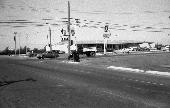
The intersection of No. 3 Road and Westminster Highway looking north west. City of Richmond Archives photograph 1988 18 7.

Starting our walk at the intersection of No. 3 Road and Westminster Highway, we look toward the north west corner and the new, modern supermarket of Canada Safeway and its parking lot. This intersection, one of the busiest in Richmond then and now, was one of the first to have a traffic signal.

b 1988 18 8

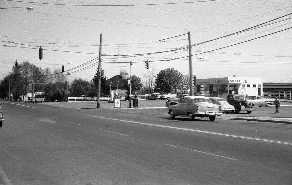
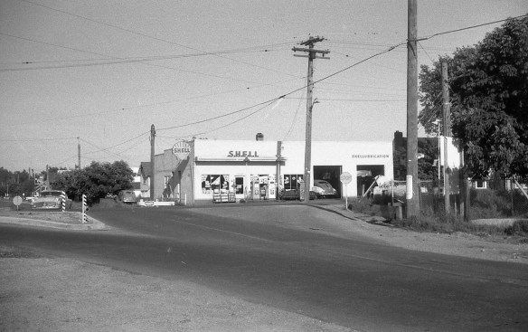
On the north east corner of the intersection was the Lansdowne Service Shell station. City of Richmond Archives photograph 1988 18 8.

Across No. 3 Road from Safeway is Lansdowne Service, a Shell gas and service station. If you drive north along No. 3 Road, there were only trees between the station and Lansdowne Park Racetrack.

c 1988 18 9

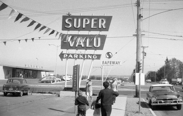
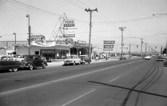
Directly across Westminster Highway from Safeway was the Super-Valu Store. City of Richmond Archives photograph 1988 18 9.

On the south west corner of the intersection, directly across the street from Safeway is its main competition, Super-Valu. Their signs compete for attention on this corner.

d 1988 18 10

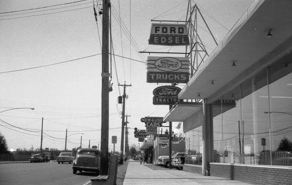
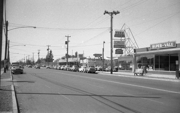
Turning around and looking south up No. 3 Road you can see the Ford dealership of Steveston Motors and the strip of commercial building an bit farther down. City of Richmond Archives photograph 1988 18 10.

Standing in front of Super-Valu and looking south along No. 3 Road you can see some of the commercial buildings on the west side of the street. Steveston Motors Ford dealership was just south of the Super-Valu store. Across the opening to their car lot is a strip of storefronts.

e1988 18 11

Looking south along No. 3 Road from the east side of the street. City of Richmond Archives photograph 1988 18 11.

If you cross No. 3 Road to the east side and look south you get a good view of Super-Valu, Steveston Motors and the row of commercial buildings. Let’s walk along the sidewalk a bit….

f 1988 18 6

Looking north toward Westminster Highway from the east side of No. 3 Road. City of Richmond Archives photograph 1988 18 6.

… and look north to see the businesses on the west side of the street, Safeway, Super-Valu and Steveston Motors. Judging by the banners and flags they’re really trying to sell those Edsels.

g 1988 18 35

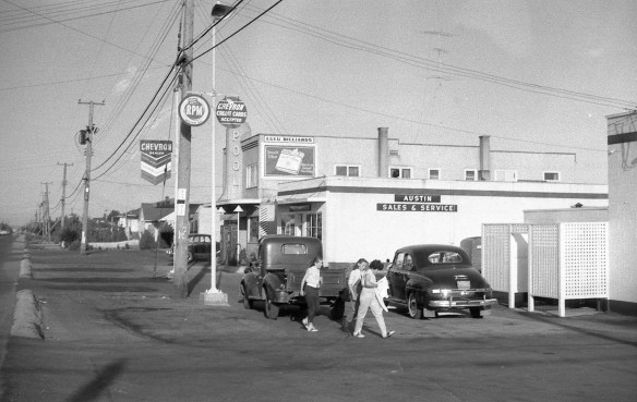
Looking east along Westminster Highway from No. 3 Road. City of Richmond Archives photograph 1988 18 35.

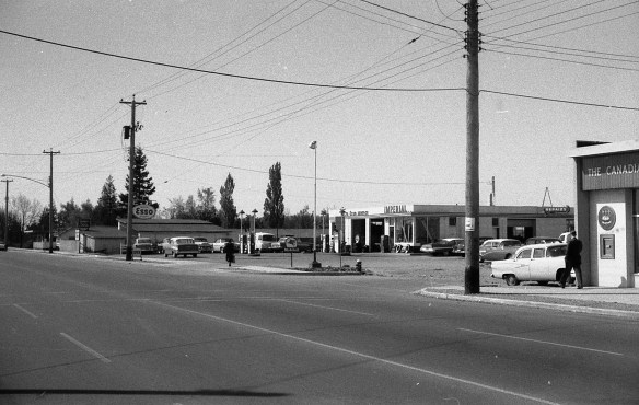
If we head back down to the intersection we can look east along Westminster Highway and see a couple of businesses just around the corner, Lulu Billiards and Jerry Pickard Motors Austin Sales and Service.

h 1988 18 34

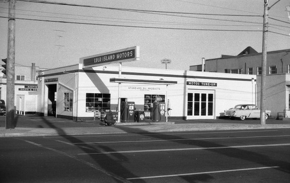
Lulu Island Motors on the coner of No. 3 Road and Westminster Highway. City of Richmond Archives photograph 1988 18 34.

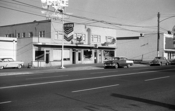
Right on the corner of Westminster Highway and No. 3 Road is Lulu Island Motors, a Standard Oil (Chevron) station where you can get gas, a tune-up and new tires.

i 1988 18 33

Looking farther south the next building houses a number of businesses. City of Richmond Archives photograph 1988 18 33.

Next to Lulu Island Motors is a commercial building with a number of businesses. The Richmond Review Newspaper is through the first door at 604 No. 3 Road. Next door is the popular Rooster Cafe. Beside the cafe is the Farmerette Grocery Store and at the end is Marpole Cleaners. Upstairs are some lawyer’s and doctor’s offices and some apartments.

j 1988 18 32

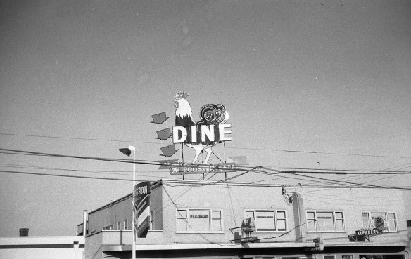
The neon sign at the Rooster Cafe. City of Richmond Archives photograph 1988 18 32.

Looking up, the neon sign at the Rooster Cafe is Richmond’s finest.

k 1988 18 31

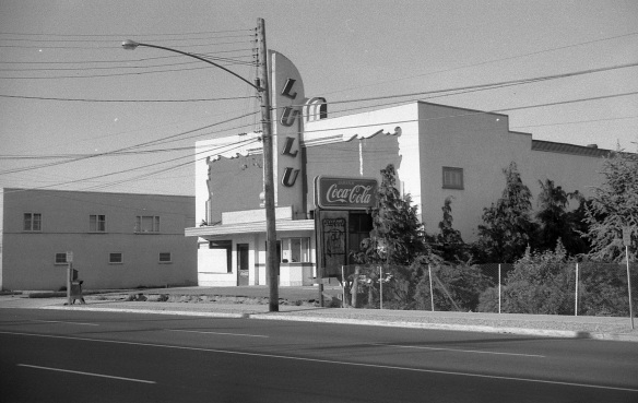
The Lulu Theatre. City of Richmond Archives photograph 1988 18 31.

Across a driveway, the next building is the Lulu Theatre, showing Hollywood’s latest movies.

l 1988 18 4

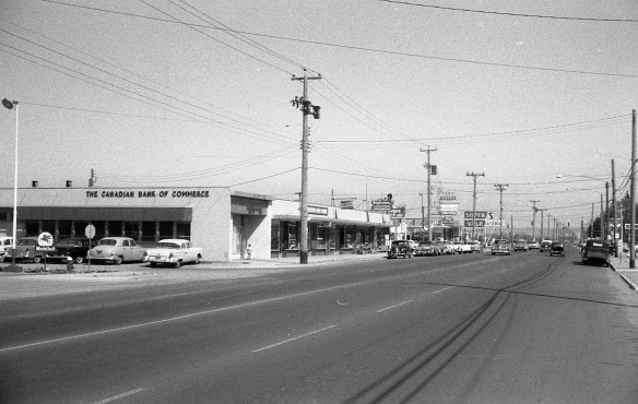
Looking north down No. 3 Road toward Westminster Highway. City of Richmond Archives photograph 1988 18 4.

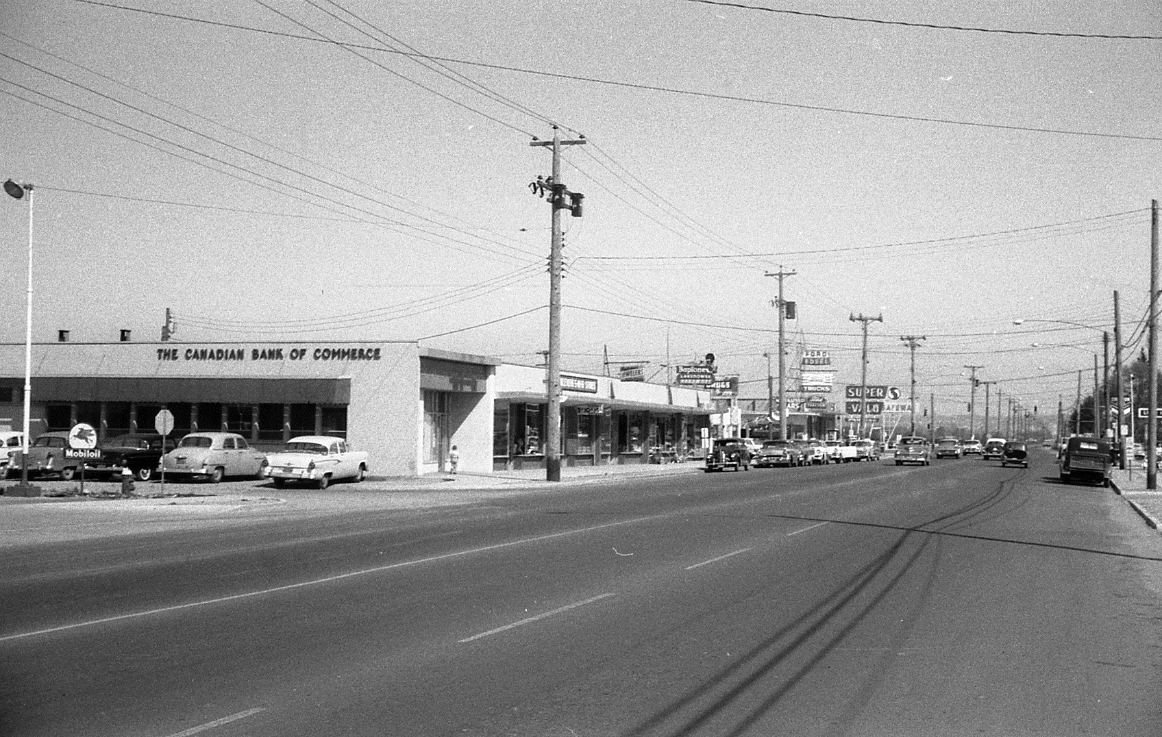
Turning around and looking north down the west side of the street you can see the buildings housing The Canadian Bank of Commerce, Kleven’s 5-10-15 Cent Store, Pemberton Jewelers, Lansdowne Hardware (selling Bapco Paints), McCue Drugs, the Island Colour Bar (selling Canada Paints) and Richmond Tailors.

m 1988 18 5

Looking south west toward 621 No. 3 Road. City of Richmond Archives photograph 1988 18 5.

Turning and looking south west, next door to the bank is the Delta Esso Service Station. In the background are the buildings at Cunningham Lumber Co.

n 1988 18 30

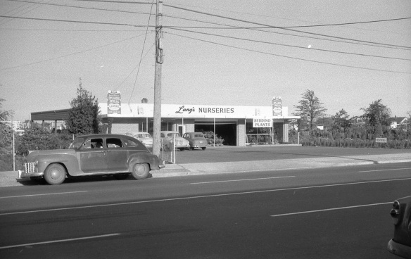
Back on the east side of the street is Lang’s Nurseries. City of Richmond Archives photograph 1988 18 30.

Looking back to the east side of the street we find a long-time family owned Richmond business, Lang’s Nurseries. The propery is filled with trees, shrubs, plants, topsoil and anything else one needs for landscaping or gardening.

o 1988 18 3

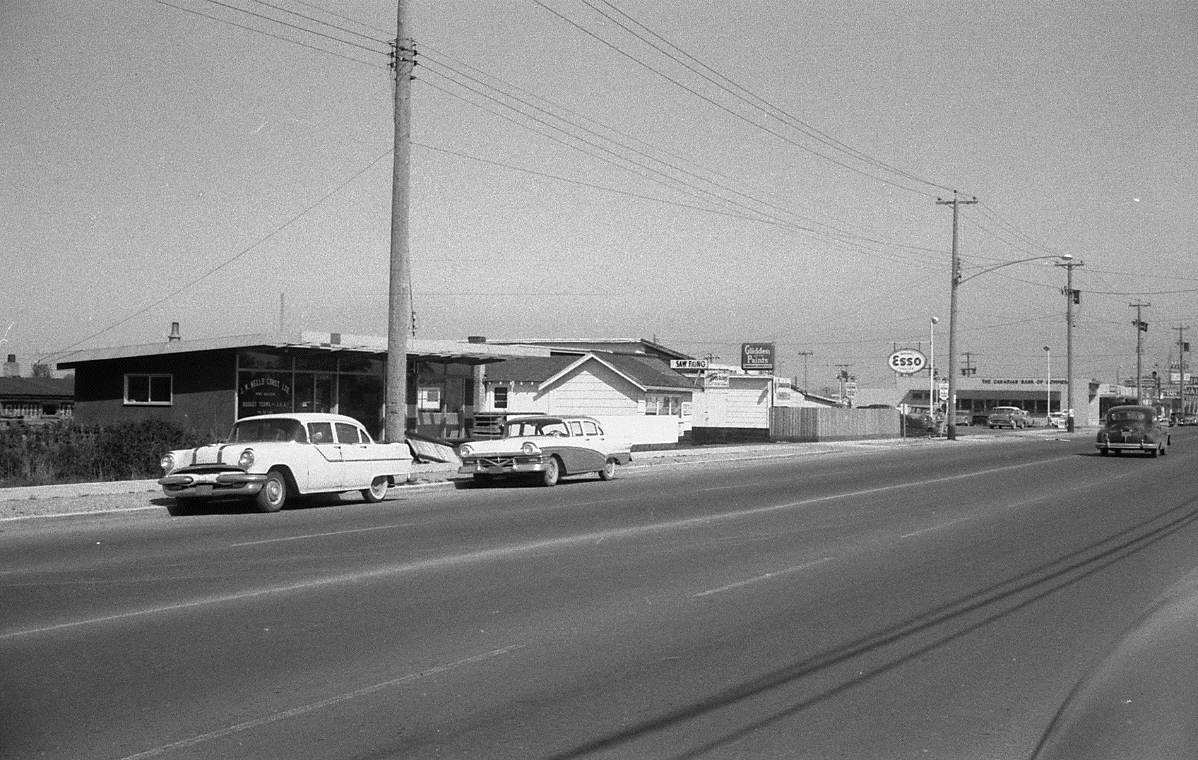
Looking north west. City of Richmond Archives photograph 1988 18 3.

Back across the street is the Cunningham Lumber Co. (selling Glidden Paint) and the offices of J.M. Wells Construction Ltd.

p 1988 18 29

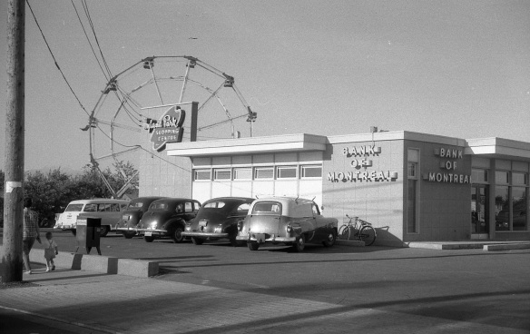
Looking north east toward the Bank of Montreal. City of Richmond Archives photograph 1988 18 29.

Back on the east side of the street again is the Bank of Montreal at the west end of the Hyland Park Shopping Centre. In the background, a ferris wheel from Royal Canadian Shows is set up in the empty lot between Lang’s Nurseries and Hyland Park.

q 1988 18 28

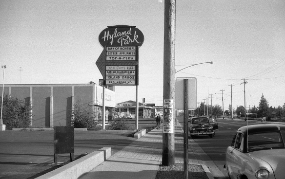
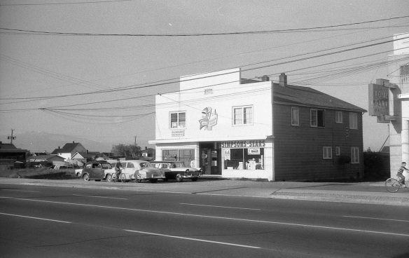
Looking south along No. 3 Road. City of Richmond Archives photograph 1988 18 28.

Turning south, we can see the sign for the Hyland Park Shopping Centre with a list of the businesses there. The Shop-Easy Grocery Store and its parking lot are just past the sign. Fastened to the telephone pole is a poster for Royal Canadian Shows at Brighouse  May 22 to 24.

r 1988 18 27

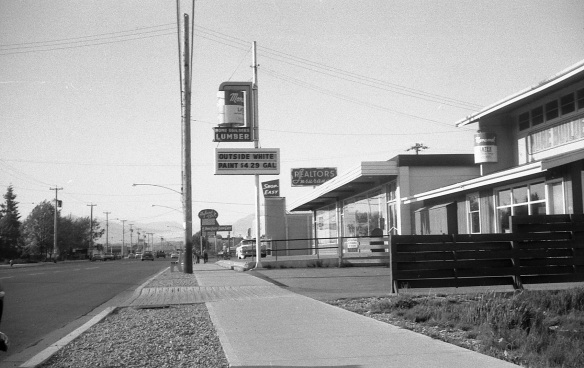
Looking north on No. 3 Road. City of Richmond Archives photograph 1988 18 27.

After walking along the street, crossing Cook Road and looking back, we can see the Hyland Park and Shop-Easy signs in the distance. Realtors Insurance and Home Builders Lumber (selling Monamel paint) are to the right.

s 1988 18 26

Simpsons-Sears Catalog Store. City of Richmond Archives photograph 1988 18 26.

Between Home Builders Lumber and this building is a large, mostly empty lot. This commercial building houses four businesses. Loreta Beauty Salon is in the ground floor left, Simpsons-Sears Catalog Store is on the ground floor right, P.A. Wolanski Accountant is upstairs on the left and the Marpole-Richmond Accordion College is upstairs on the right.

t 1988 18 24

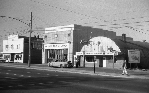
The east side of No. 3 Road. City of Richmond Archives photograph 1988 18 24.

Next door is the Brighouse Branch of the Royal Bank of Canada and a Masonic Lodge, and next door to that is the Brighouse Bola-Drome bowling alley and cafe. A group of young guys with slicked back DA haircuts loiter outside and the advertising sign requests “Players Please!”

u 1988 18 25

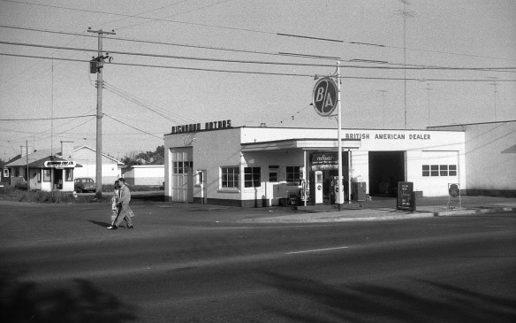
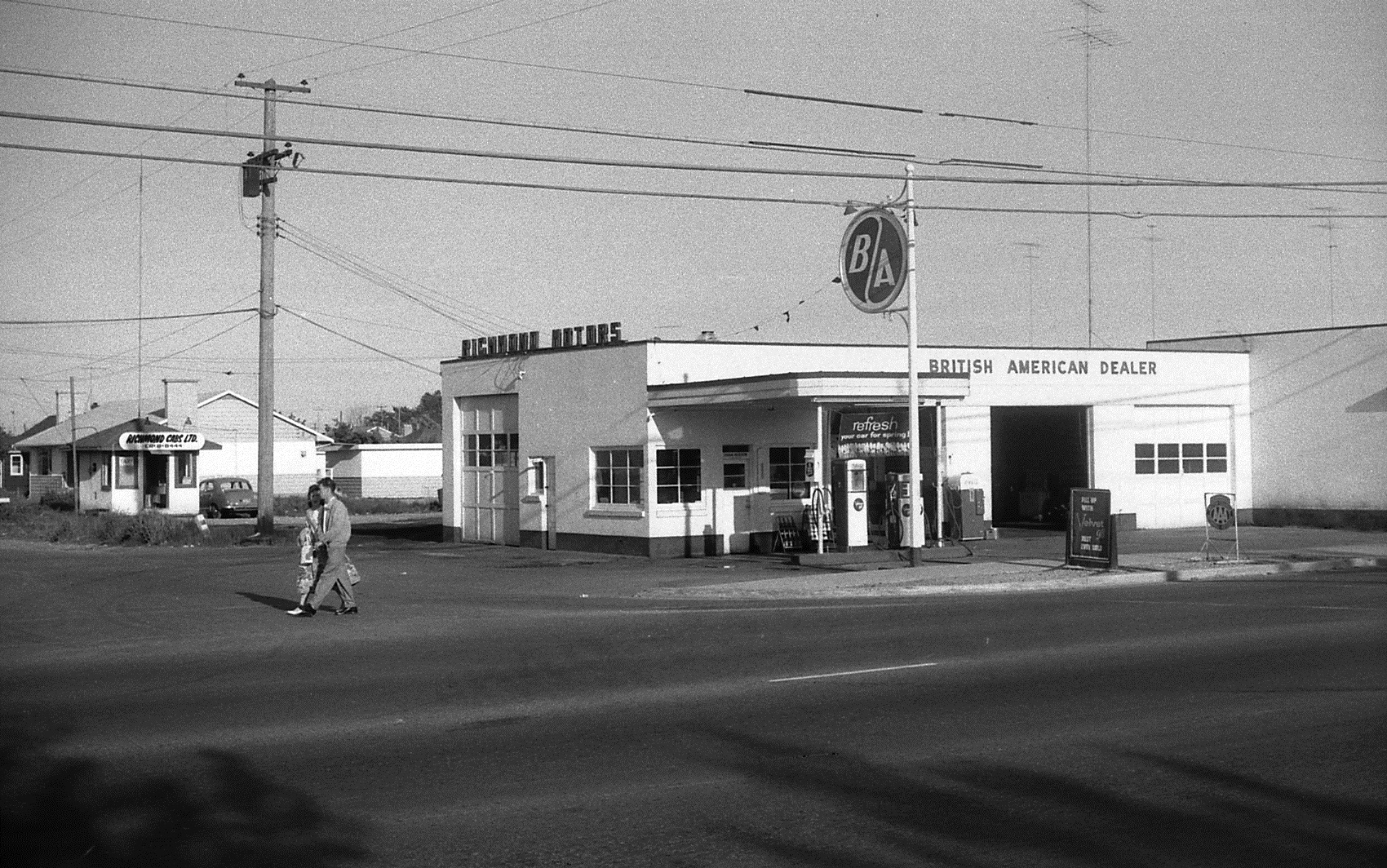
Looking east to the corner of Park Road and No. 3 Road. City of Richmond Archives photograph 1988 18 25.

Crossing the intersection of Park and No. 3 Roads we come to Richmond Motors, a BA service station. Behind the station on Park Road is the office of  Richmond Cabs (Call CR-8-8444).

v 1988 18 23

Looking east toward 680 No. 3 Road. City of Richmond Archives photograph 1988 18 23.

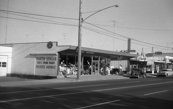
Next to Richmond Motors the building at 680 No. 3 Road houses two businesses. Brighouse Hardware (selling Martin-Senour Paint) and Gordon’s Rexall Drugs.

w 1988 18 22

Looking east toward 682 No. 3 Road. City of Richmond Archives photograph 1988 18 22.

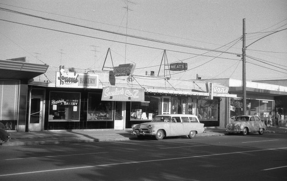
Beside the drug store, 682 No. 3 Road has four more retail outlets. Starting at the north end is Harris’ Bakery, Scoular’s Shoe Store, the Island Meat Market (Percy and Bob Eeles, proprietors) and Ivan’s Men’s Wear.

x 1988 18 21

Looking east toward 684 No. 3 Road. City of Richmond Archives photograph 1988 18 21.

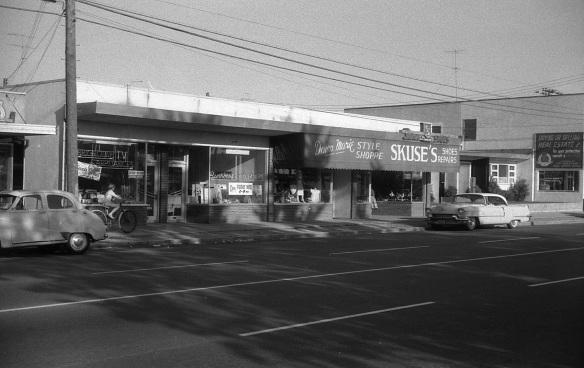
Four more businesses occupy 684 No. 3 Road. Brighouse Television sells TVs, radios and appliances as well as doing service and TV antenna installations. Next door, Burrows Cleaners provides laundry service, including pick-up and delivery.  Dawn Marie Style Shop offers the latest fashions for ladies and they can go next door to shop for shoes to go with their new dress at Skuse’s Shoes. The small building next door at 686 No. 3 Road (Behind the big Cadillac) is Dr. Booth’s Dentist Office and Dr. Talmey’s and Dr. Varley’s doctor’s office.

y 1988 18 20

Looking east toward 688 No. 3 Road. City of Richmond Archives photograph 1988 18 20.

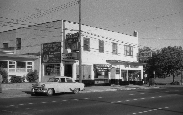
Just south of the doctor’s offices is a large two-storey commercial building  at the corner of Anderson Road and No. 3 Road. The first space is occupied by Richmond Realty with its clock sign and marquee which asks, “What Recession?”. Next to it is the Sea-View Bakery. Beside the bakery, a door leads to stairs to the second floor where Dr. Kita has his dental office, Dr. Fagen has his medical practice and where chartered accountant Donald Ross, and lawyers A.A. McDonald and F.R. Spry have their offices. At street level, the south corner of the building houses Porter’s Brighouse Pharmacy.

z 1988 18 19

Looking south east toward 690 No. 3 Road. City of Richmond Archives photograph 1988 18 19.

Across Anderson Road is an old wood framed commercial building holding the storefront of  Grayshon & Morgan Electrical Contracting and Plumbing Services. Next door is the Brighouse Beauty Shop, open Friday ’til 9:00 PM.

zz 1988 18 18

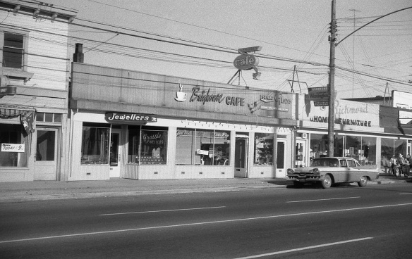
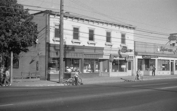
Looking east across toward 692 No. 3 Road. City of Richmond Archives photograph 1988 18 18.

Next to the beauty parlour at 692 No. 3 Road is Grassie Jewellers and next to that is a Richmond favorite, the Brighouse Cafe, offering “Good Food” in their Cafe and Dining Room. Next door is Island Glass who deal in “Glass of all kinds, for every purpose”, Lyall Grath, proprietor.

zzz 1988 18 17

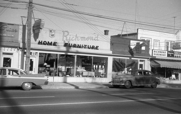
Looking east toward 694 No. 3 Road. City of Richmond Archives photograph 1988 18 17.

At 694 No. 3 Road we find Richmond Home Furniture, a large furniture store offering trade-ins and good deals on all kinds of furniture and flooring. Next door is a two in one business, Naimark’s Dry Goods sells “Ladies and Kiddies Wear” and in the same store, Naimark’s Dry Cleaning cleans them.

zzzz 1988 18 16

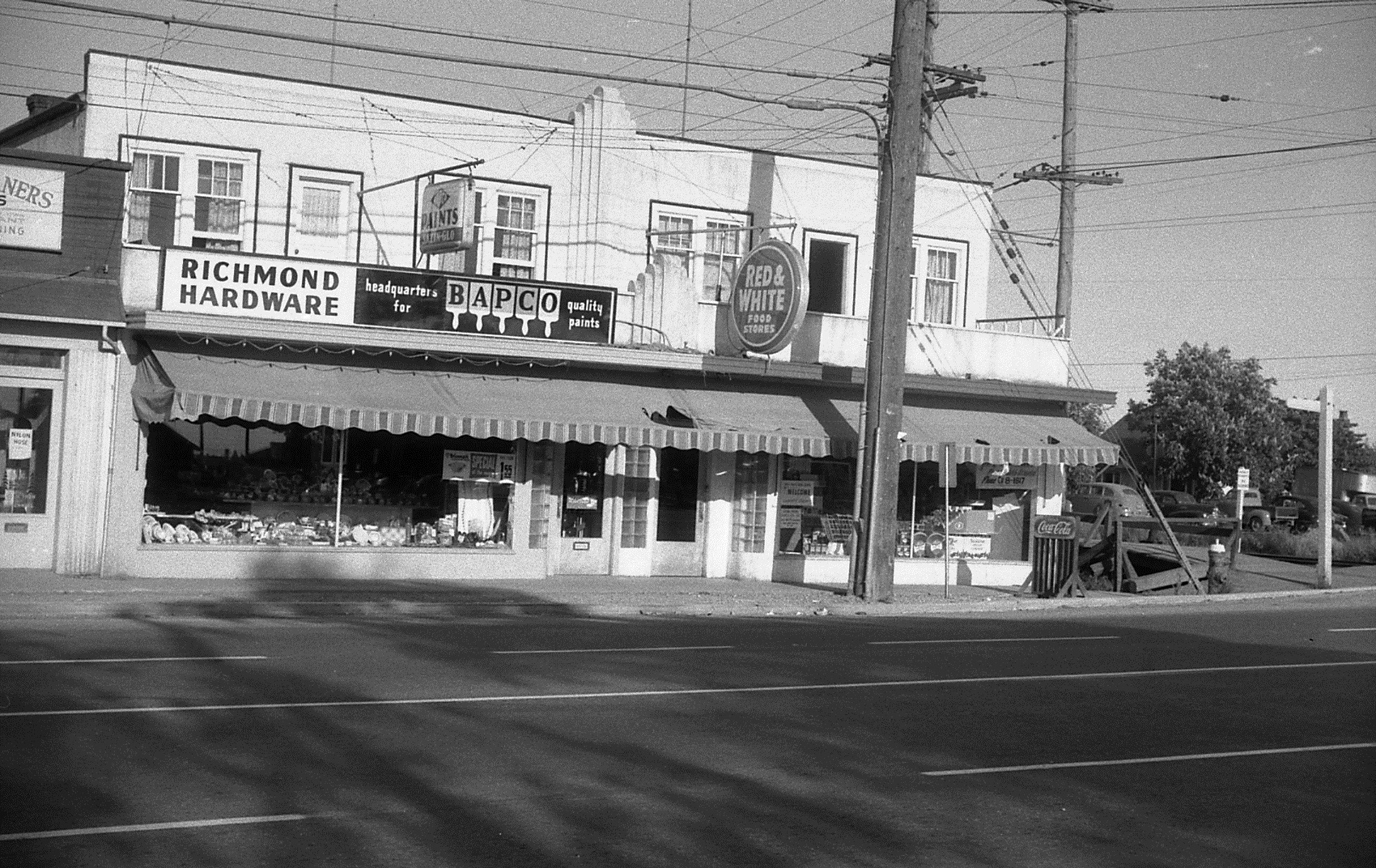
Looking east toward 696 No. 3 Road. City of Richmond Archives photograph 1988 18 16.

The last building before Granville Avenue is the location of Richmond Hardware and the Brighouse Grocery – Red & White Store. The hardware store sells Bapco Paint, it seems like a lot of  places sell paint on No. 3 Road. The grocery store was a longtime business in Richmond, run by the Meyer Family. Upstairs, two apartments enjoy a balcony overlooking the street. Just across the street from this location is the Richmond Town Hall and just around the corner behind the store is Brighouse Station of the recently closed BC Electric Railway Interurban Tram.

zzzzz 1988 18 15

Looking east toward 700 No. 3 Road. City of Richmond Archives photograph 1988 18 15.

We’ll finish our walk down No. 3 Road by looking across Granville Avenue and No. 3 Road at the Parkview Service Garage. Brighouse Park is to the west of it and to the south is mostly houses. No. 3 Road between Westminster Highway and Granville offered most of the services anyone might need during the 1950s all contained within a few blocks. We’re fortunate that an unknown tax assessor decided to document this area and leave us with this detailed example of a point in time of Richmond’s development.

From Racetrack to Farmer’s Field – Early Aviation on Lulu Island

Richmond has had an association with flight since the first time an airplane took off under its own power in our province. Purpose-built airports did not exist in the early days. Aviators used existing facilities to operate their machines and farm fields, fair grounds and horse racing tracks served the purpose. The latter two were already equipped with grandstands to hold the crowds which gathered, each person paying to witness the fledgling technology of flight and perhaps the spectacle of a crash.

                                    Minoru Park – Brighouse Park Racetrack                                Exhibition Flying and Barnstorming

The place where most of the early milestones of flight in British Columbia took place was Minoru Park Racetrack. Opened in 1909, the mile-long oval occupied the property on which can now be found Richmond City Hall, the south part of Richmond Centre Mall, the Richmond Public Library and Cultural Centre, Richmond Arenas, Richmond Aquatic Centre and the present Minoru Park. On Friday, March 25, 1910, Charles K. Hamilton became the first person to fly an aeroplane in British Columbia when he lifted off in front of 3500 cheering spectators at Minoru Park.

1978 15 18 Charles K. Hamilton made the first airplane flight in British Columbia at Minoru Park Racetrack on March 25, 1910 in this Curtiss biplane. As can be seen in this photo, the aircraft had a hard landing on the infield of the track, bending one of the landing wheels, but was repaired and carried on with its demonstration. (City of Richmond Archives photograph 1978 15 18)

In those dawning days of aviation when the mere sight of a man flying in a machine was thrilling enough to attract thousands of onlookers, Hamilton’s Easter weekend exhibition did not disappoint the crowds. On Friday, after swooping around the grandstand for about ten minutes, the plane swerved suddenly to the centre of the field and landed hard, causing some damage to the undercarriage. Quickly making some repairs, he got the engine started and continued his display.

On Saturday, Hamilton took off again, this time disappearing from view for about twenty minutes, flying to New Westminster where streetcars stopped to let the passengers watch. On his return to Richmond he landed briefly for a refreshment, then took two more flights, one in which he lost a race with a car.

RCF 116 Hamilton takes to the air in the Curtiss biplane at Minoru Park Racetrack. City of Richmond Archives photograph RCF 116.

On Monday, the exhibition continued, this time featuring a competition with the racehorse Prince Brutus who was given a 3/8 of a mile handicap. The horse took full advantage of its head start, passing the post before the aircraft.

The aircraft that Hamilton flew was historic in its own right. Known as the Rheims Racer, it was built by Glenn H. Curtiss, a central figure in the history of aviation, to compete in the Gordon Bennett Race at Rheims, France on August 29, 1909. The aircraft proved to be superior to the other entrants in the race, a timed closed circuit flight of twenty kilometres, beating his nearest rival, Louis Bleriot, by five seconds to win the Gordon Bennett Aviation Cup and a large cash prize. Curtiss took part in several other meets and races in Europe before shipping the aircraft back to North America where it was leased to Hamilton for use in exhibition flying.

Exhibition flying took place regularly at Minoru Park Racetrack after the flights by Hamilton. In April 1911 a disappointing show was put on by Jack DePries and the Manning Brothers. Widely derided by spectators and the local press, the three day exhibition featured several minor crashes and not much actual flying by the trio, who apparently displayed little skill or experience at operating their aircraft.

In May the same year came test flights at Minoru Park of the Templeton – McMullen biplane, the first aircraft to be designed and built in Vancouver. The aircraft managed several short hops, hampered by an under-powered engine.

1985 166 20A Built in Vancouver by William and Winston Templeton and their cousin William McMullen, the Templeton-McMullen aircraft managed to make a few short hops during trials at Minoru Park Racetrack, but was limited by its under-powered engine. City of Richmond Archives photograph 1985 166 20A.

In April 1912, Billy Stark, BC’s first licensed pilot, flew at Minoru in a Curtiss biplane. During his exhibition program he carried the first aircraft passengers in British Columbia. The first was James T. Hewitt, sports editor of the Daily Province newspaper. Seated on the wing of the aircraft, which was not equipped for passengers, the plane took off from a farmer’s field near the racetrack, long enough to allow the craft to take to the air with the extra load. Hewitt described the experience as “like riding on the cowcatcher of an express locomotive”. Stark’s wife Olive became the first woman to be carried in an airplane in the province the same day.

In August of 1912 aviator and inventor James V. Martin flew his self designed aircraft at Minoru. In July of 1913 a popular aviation show, the Bennett Aviation Company came to Minoru Park. The show featured pilot John Bryant and his wife Alys McKey Bryant who would be the first woman to pilot a plane in British Columbia.

By 1914, aircraft were becoming a more familiar sight in the skies of BC and spectators were less willing to pay to see them. The beginning of World War I in July of that year limited exhibition flying as aviation took on a more serious purpose. The wartime advances in aviation technology and the need to train pilots who would be able to join the Royal Flying Corps led to the formation of flying schools in Canada, the second of which was organized in the summer of 1915 by the newly chartered Aero Club of British Columbia, and began training aviators at Minoru Park. The racetrack soon proved to be too small for flight training purposes and the operation was moved to the Milligan Farm at Terra Nova where a larger field was available. A small hangar building was erected and the flight school operated there until 1916, when it moved to Pitt Meadows.

Horse racing had been discontinued for the duration of the war at Minoru Park but aircraft continued to fly sporadically there. Once the war was over large numbers of modern aircraft and trained airmen came on the scene. The Aerial League of Canada was formed by returned airmen who had developed a love of flying and wanted to promote aviation in Canada. Branches formed around the country, including ones in Vancouver and Victoria. By the summer of 1919 a small hangar had been built and at least five aircraft were based at Minoru Park, mostly war surplus Curtiss JN-4 (Canucks). Commonly known as the Jenny, it was a plane which was the workhorse of the barnstorming era and was used to take the first steps into commercial aviation.

2012 35 This aerial view of Minoru Park Racetrack was taken during the Aerial League of Canada’s meet on May 31, 1919. Cars line the track and several planes can be seen on the ground as the BC Electric Railway’s Interurban Tram drops off spectators at the racetrack’s tram stop. City of Richmond Archives photograph 2012 35.

The league’s promotion of aviation raised flying in the public attention by putting on “barnstorming” demonstrations and accomplishing “firsts”. The first flight across Georgia Strait took place on May 13, 1919 when two members of the League took off from Minoru Park, landed in Victoria, had dinner at the Empress Hotel and then flew home. The Aerial League put on several displays at Minoru in 1919 featuring wing walking, aerial acrobatics and races between planes as well as races between a plane and a race car.

1984 17 69 Races between aircraft and horses or cars were a regular feature of aviation displays at Minoru Park. Here’s an image of driver Harry Hooper in the “Vulcan Kewpie” Stutz, accompanied by silent film star Priscilla Dean. Hooper raced an airplane piloted by Lieut. G.K. Trim at Minoru in an event hosted by the Aerial League of Canada on Dominion Day, 1919. City of Richmond Archives photograph 1984 17 69

On August 7, 1919 Ernest C. Hoy, lifted off from Minoru Park and flew into history as the first person to fly across the Rockies. The plane was fitted with an extra 12 gallon fuel tank to allow it to stay in the air for at least four hours. As navigational aids, Hoy used a pocket watch and a railway contour map and he carried 45 officially marked letters as well as a bundle of special edition “Vancouver Daily World” newspapers, making this the first Air Mail flight over the Rockies as well. Hoy landed at Vernon, Grand Forks, Cranbrook and Lethbridge where he could eat, fuel up and have his aircraft adjusted by experienced “air machine men” before making his final landing at Bowness Park in Calgary.

1977 20 3 Ernest C. Hoy stands beside his Curtiss “Jenny” at Minoru Park Racetrack before his historic flight across the Rockies to Calgary, August 4, 1919. City of Richmond Archives photograph 1977 20 3.

Another first for Minoru Park came at 11:25, October 17, 1920, when a DeHavilland DH9A touched down on the field completing the Canadian Air Board – Canadian Air Force Trans-Canada Flight. This undertaking which involved several different aircraft and pilots, started in Halifax and took 247 hours, almost twice as long as taking the train, but still an important milestone in Canadian aviation history.

Lansdowne Field – The Start of Commercial Aviation

Aviation developed rapidly through the 1920s. Sea planes became more common, not requiring large open fields for landings or takeoffs, but the Lower Mainland still had no purpose built airport for land based aircraft. The crunch came in 1927 when Charles Lindbergh refused to land at Vancouver during his North American tour following his trans-Atlantic flight, saying there was no airport worth landing at.

Airport plan 1928 ser. 25 file 3411-1 This 1928 plan shows the BC Electric Railway line and the cross over to the Vancouver airport on Lulu Island. City of Richmond Archives Airport Plan 1928 ser. 25 file 3411-1.

At the same time the Dominion Airways Company was looking for a suitable place for a small airport from which to run their business. They found a field owned by a farmer named Summerfield along the north side of Lansdowne Park Racetrack. The City of Vancouver, who also wanted an airport, became interested in the property and leased it from Mr. Summerfield for use as an airfield in 1928.

1984 4 52 The Vancouver Airport building at Lansdowne Field, ca. 1929. With the buildings and tram wires at the east end of the runway and the poles and wires running down No.3 Road at the west end, pilots needed to take off and land as quickly as possible. City of Richmond Archives photograph 1984 4 52.

Lansdowne Field became British Columbia’s second licensed airport, opening officially in May 1929. While it was only intended to be a temporary facility until a permanent site could be designed and built on Sea Island, the airport became the hub of aviation in the Lower Mainland during its operation.

1984 4 49 Harry Smithson, Aviator and member of the  Aero Club of BC, stands next to a Dehavilland Moth at the Vancouver Airport near Lansdowne Park. In the background, the Alexandra Station of the BC Electric Railway can be seen, as well as a house which is still standing on the corner of Alexandra and Garden City Roads. City of Richmond Archives photograph 1984 4 49.

The field was home to several commercial aviation companies and flight schools run by the Aero Club of BC and Sprott Shaw College. In 1930, gliders were also used to teach elementary flight principles and give students practice at flight control. They were launched using an old Maxwell automobile and a four hundred foot towrope which could let them achieve an altitude of about 200 feet before cutting loose and landing at the airport.

1989 19 8 A primary glider is launched at the Vancouver Airport at Lansdowne. The grandstands of Lansdowne Park Racetrack can be seen in the background. City of Richmond Archives photograph 1989 19 8.

The Vancouver Airport on Lulu Island was not the ideal location for a centre of aviation, however it filled the requirements for the time it took to design and build the airport on Sea Island. None of the businesses which operated from Lansdowne Field survived the early years of the depression. Only the Aero Club of BC, subsidized by the government,  managed to make the move to the new facility.

1985 166 2 The Vancouver Airport on Lulu Island as it looked from the air. On the right, Lansdowne Park Racetrack can bee seen. Airport buildings and hangars can be seen at the east end of the runway. The track for the BC Electric Railway Tram and the intersection of Alexandra Road and North Railway Avenue (now Garden City Road) is visible at the top of the image, City of Richmond Archives photograph 1985 166 2.

By 1930 construction was well underway at the new airport on Sea Island and after its opening on July 22, 1931 aviation activity ceased on Lulu Island. Since the 1930s the Vancouver Airport has grown and expanded to the large International facility it is today, owing its existence to those first flimsy craft that struggled into the air across the Middle Arm from where jumbo jets land today.

1985 166 15 An aerial view of the Vancouver Airport on Sea Island during its construction in 1931 shows a small development on a rural landscape. The airport has expanded occupy almost all of the land on the island. City of Richmond Archives photograph 1985 166 15.


Traffic Congestion in Richmond – Bumper-to-Bumper Through the Years

Traffic congestion has been a major topic of conversation among Richmondites from the early age of motor cars to the present day.

1988 95 1

Traffic on No. 3 Road, as viewed from the Ackroyd farm, ca. 1915. City of Richmond Archives Photograph 1988 95 1

Roads like No. 3 Road have always been problematic for traffic, witness Council minutes and resolutions like this: “Decision to place Danger Signs near the corner (curve) at the end of No. 3 Road on the River Road owing to two bad curves and congested traffic.” (June 25, 1923)

Traffic at Brighouse Park Race Track, 1921. City of Richmond Archives Photograph 1978 13 5

Traffic at Brighouse Park Race Track, 1921. City of Richmond Archives Photograph 1978 13 5

Special celebrations and events have always caused traffic congestion and parking problems.  From sporting events and May Day celebrations to horse racing fixtures at the two Richmond thoroughbred tracks, travel often meant long line ups and delays.

Line-up for the Ladner ferry on No. 5 Road, 1947. City of Richmond Archives Photograph 1997 16 19

Line-up for the Ladner ferry on No. 5 Road, 1947. City of Richmond Archives Photograph 1997 16 19

Richmond’s geographic location on islands in the Fraser River has always posed problems for traffic at river crossings.

Whether it be the ferry to Ladner or crossing the old Marpole and Fraser Street Bridges, bumper-to-bumper traffic was a normal component of a commuter’s day.

Bumper-to-bumper traffic on the Sea Island side of the Marpole Bridge, 1955. City of Richmond Archives Photograph 1997 42 3 145

Traffic congestion on the Sea Island side of the Marpole Bridge, 1955. City of Richmond Archives Photograph 1997 42 3 145

Here’s an account by Grant Thompson of the Sea Island Heritage Society of the problem of crossing the Marpole Bridge at rush hour in the 1950s:

“One of the results of these traffic jams was that both Lancaster Cres. and Catalina Cres. were turned into one-way streets south bound. During rush hour many drivers would race north down either street and then try to cut back onto Miller in the case of Catalina or back onto “Airport Highway” at the north end of Lancaster. Barricades blocked access to Miller Road at Wellington Cres. and at the lane on the east side of Sea Island School. Add to this the traffic from the Airforce Base on Miller Road and the traffic from Cora Brown on Grauer Road turning left onto the Bridge and you had one big mess coming from Sea Island.  Also contributing to this back up was traffic heading to the Lansdowne Race Track which backed up in old Marpole and also the traffic making a left turn cutting across the Air Port Highway to use the Bridgeport bridge and traffic coming from the west from Lulu Island merging onto the Marpole Bridge in front of Grauer’s store. Add to this the opening of the Marpole Bridge for boat traffic which happened often depending on which way the tide in the river was going. It was quite often 8 o’clock in the evening before the traffic eased off. The odd configuration of the street intersection didn’t help matters in Marpole. During these back-ups there were two Vancouver policemen detailed to directing traffic in Marpole. The parking lot at the ANAF club was always full; people would stop and have a few beer and wait out the rush hour. In fact it was much faster to walk the mile from Burkeville, go to the show at the Marpole Theater and catch the bus home after the movie. The Fraser Bridge was not much better as it also backed up for many of the same reasons.”

Construction tie-ups on No. 3 Road, 1985. City of Richmond Archives - Richmond Review Photograph 1988 121 - August 21 1985.

Construction tie-ups on No. 3 Road, 1985. City of Richmond Archives – Richmond Review Photograph 1988 121 – August 21 1985.

Modern transportation and traffic planning and the return of commuter rail to Richmond with the Canada Line have alleviated some of the earlier traffic nightmares.  Traffic congestion and its associated problems, however, still remain a major challenge for Richmond and other municipalities in the Lower Mainland.