Road Names in Richmond – Addressing Community History

Street signage in Richmond. Where do those names come from? (Graham Turnbull photograph)

Street signage in Richmond. Where do those names come from? (Graham Turnbull photograph)

The use of road names as opposed to numbers in Richmond provides residents with a great opportunity to understand the social history of their community.  In a relatively young municipality such as Richmond, people may be lucky enough to meet a neighbour or individual who possesses the same name as the road on which they live, and then on further inquiry discover the identity and significance of that individual’s ancient (or not so ancient) family member.

Excerpt from Council minutes of May 6, 1880, showing first page of motion to petition to declare public highways for No. 1 Road through No. 13 Road. City of Richmond Archives, MR 1, File 1-1

Excerpt from Council minutes of May 6, 1880, showing first page of motion to petition to declare public highways for No. 1 Road through No. 13 Road. City of Richmond Archives, MR 1, File 1-1

The early surveys of Richmond used a road numbering system for convenience, so the numbers themselves, while seemingly boring if you are not a surveyor by profession, have historical significance.  Most residents of Richmond understand that the City’s main north/south numbered roads run parallel to each other at a distance of one mile between.

Numbered east/west roads, however, had their names changed in the 1930s, making intersection identification a lot easier.   Steveston Highway used to be No. 9 Road – and No. 9 Road is now a north/south road in east Richmond;  Blundell Road was No. 18 Road;  Westminster Highway was No. 19 Road; and Cambie Road was No. 20 Road….  oh  – and before that, it was No. 10 Road.  And so on.

Street map of Richmond, 1937, showing changes to numbered east/west roads, along iwth old names in parentheses. City of Richmond Archives Map 1989 11 1

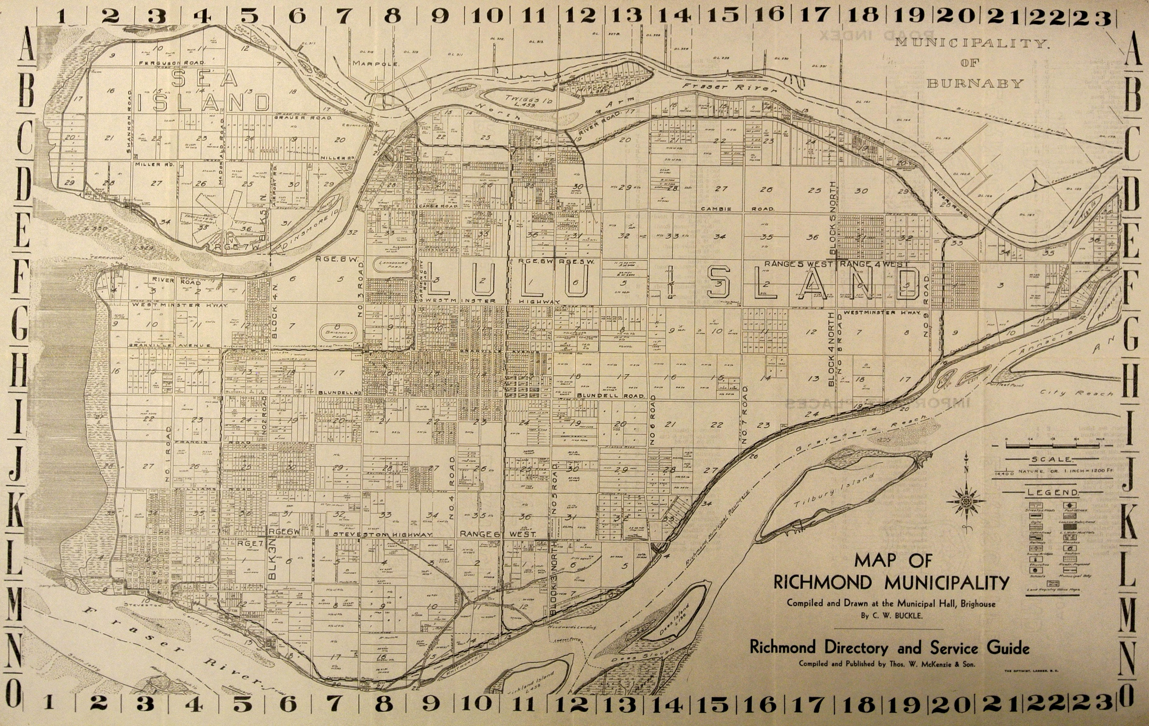
Street map of Richmond, 1937, showing name changes to numbered east/west roads (with old names in parentheses). City of Richmond Archives Map 1989 11 1

The process for choice and selection of road names in Richmond has been applied with solemnity, enthusiasm, practicality and fanciful desperation over the years, and gradually morphed into a more thoughtful and organized responsibility, with Council approved road-naming  policies being adopted in 1979, 1984 and 1997.

The policies also provide a guide to definitions for the address descriptors such as: “Court: A court is a cul-de-sac which cannot be extended.  It may carry the name of the street from which it originates, but no more than one such court can be so named.   The term ‘place’ can also be used for a court;” “Gate: a gate is a short street less than 106 m (350 ft.) in length connecting two other streets;” “Crescent: A crescent is a named street in the form of a loop, both legs of which terminate on the same street…;” and my own personal favourite since I live on one, Drive: a drive is an irregular or winding street over 230 m (750 ft.)  in length and connecting two other streets”.

Street sign at corner in the old Cora Brown subdivision. McDonald Road (still in existence) was named after pioneer farming family on Sea Island. Edgington Avenue (disappeared with the federal expropriation of Cora Brown for airport expansion)  was named after Private Erine Edgington, a former Richmond High student, who was killed in action in Italy during World War II. City of Richmond Archives Photograph 1997 42 1 483

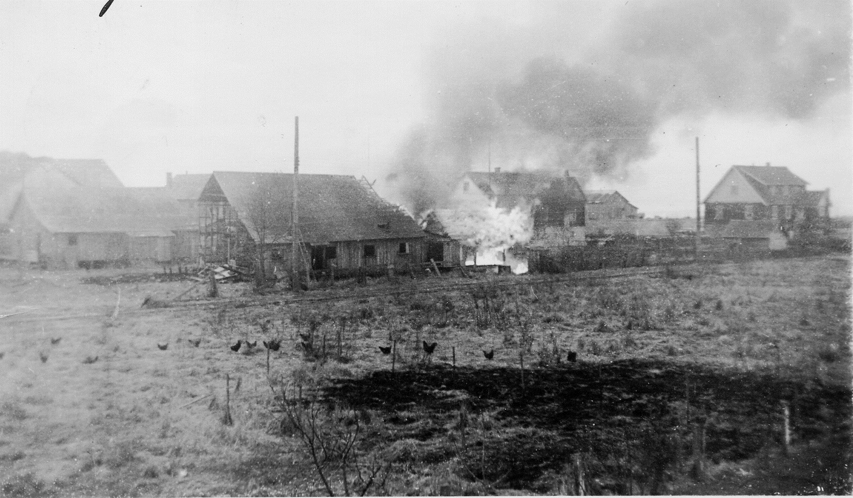
Street sign in the old Cora Brown subdivision on Sea Island. McDonald Road (still in existence) was named after a pioneer farming family. Edgington Avenue, which disappeared with the federal expropriation of the subdivision for airport expansion, was named after Private Ernie Edgington, a former Richmond High student, who was killed in action in Italy during World War II. City of Richmond Archives Photograph 1997 42 1 483

So regarding the title of this blog – Richmond’s street names have come to our community from early pioneers, Richmond Good Citizens, land-owners and farmers, residents who died in their duty to country during the First and Second World Wars, members of royalty and their horses, politicians, general public sentiment, developer fancy and corporate sponsorship. The names chosen are not carved in stone, and a look at some of the now defunct names is an interesting study.

Research into the origins of Richmond’s road names is a fascinating and educational exercise.  Sometimes the origins are lost in the mists of time, with no recorded evidence of why the name was chosen. Over the coming months, I’ll be taking a closer look at the Archives’ records and sharing some of the mysteries, secrets and stories behind the names, via this blog.

[Note: this is the first of a series of blogs by Christine McGilvray on road naming in Richmond.  Christine, an active Archives volunteer and Past President of the Friends of the Richmond Archives, has been researching road names at the City of Richmond Archives for several years.]

From the Archives Kitchen – Sour Cream Doughnuts

A tasty, 1930-style, homemade sour cream doughnut. (Bill Purver photograph)

A homemade, 1930-style, sour cream doughnut. (Bill Purver photograph)

Before the proliferation of specialty bakeries and fast food chains in the latter half of the 20th century, the search for a fresh doughnut to accompany an afternoon coffee often ended up in one’s own kitchen.

An old recipe for homemade sour cream doughnuts was recently discovered at the City of Richmond Archives in records of the Ladies’ Aid of Richmond United Church.

Cover of "Tested Recipes" published in 1930 by the Ladies Aid to Richmond United Church. City of Richmond Archives, Richmond United Church fonds, Series 5, File 3

Cover of “Tested Recipes.” City of Richmond Archives, Richmond United Church fonds, Series 5, File 3

The recipe was found in “Tested Recipes”, a book published in 1930 by the women’s group as a fundraising effort on behalf of the church situated at the corner of River Road and Cambie.

Richmond United Church at the corner of River Road and Cambie, ca. 1930. City of Richmond Archives Photograph 1985 39 104

Richmond United Church at the corner of River Road and Cambie, ca. 1930. City of Richmond Archives Photograph 1985 39 104

Constructed in 1891 as the Richmond Methodist Church and renamed the Richmond United Church in 1925 after church union, the building was later purchased by the municipality, moved to Minoru Park in 1967, and renamed Minoru Chapel.

Ad supplied by BC Electric Railway Company on inside of front cover of "Tested Recipes."

Advertisement on inside front cover of “Tested Recipes.”

The recipe book is a collection of old family recipes submitted by church members, the names of whom read like a who’s who of some of early Richmond’s most prominent residents.

Contributors included Mrs. H.A. McBurney, Mrs. R.P. Ketcheson, Mrs. E. Cooney, Mrs. W.G. Easterbrook, Mrs. J.W. Miller, Mrs. James Thompson, Mrs. Grauer, and Mrs. Mitchell among others.

The book was sponsored by various companies and includes advertisements for services and products of interest to those who would be using the recipes.


Recipe for Sour Cream Doughnuts on page 13 of "Tested Recipes."

Recipe for Sour Cream Doughnuts on page 13 of “Tested Recipes.”

The Friends of the Richmond Archives’ resident pastry chef and Board Director, Precilla Huang, decided to try out the recipe to gain insight into the culinary expertise and practices of homecooking in the 1930s.

A tasty plate of homemade doughnuts using the 1930 recipe. (Graham Turnbull photograph)

A tasty plate of homemade doughnuts, thanks to Friends of the Richmond Archives Board Director Precilla Huang and the 1930 “tested recipe.” (Graham Turnbull photograph)

The end result of Precilla’s work was delicious, a doughnut much less sweet than that of the present day, but rich in texture and taste.

(Note: “Doughnut” is the traditional spelling of the word and consistent with usage in the 1930s.  “Donut” is a modern-day spelling associated with the later, large-scale commercialization of the snack.)

Focus on the Record – Records of Early Policing

Richmond has had four distinct policing regimes, each documented in records held at the Archives: police constables appointed by Council, a small force regulated by a Board, the BC Provincial Police and lastly the RCMP.

Chief of Police Andrew Waddell in 1914. City of Richmond Archives Photograph 1985 206 1

Chief of Police Andrew Waddell in 1914. City of Richmond Archives Photograph 1985 206 1

The earliest police force consisted of a constable or constables appointed and administered by Town Council. An overview of this early development can be had by reading Council minutes and reports to Council from that period.  Other municipal records and reference material in the Archives provide reference for important events involving the police, including the murder of Chief of Police Alexander Main in 1900.

The oversight of policing activities was enhanced by the creation of two bodies separate from Council. The Board of Licence Commissioners was established in 1889 with the power to licence and inspect establishments such as hotels and saloons serving liquor.  Enforcement activities relating to this licensing were carried out by police constables. The Archives holds the minutes of the Board from 1894 to 1917, which tell a colourful if partial tale of Richmond’s early night life.

Report to the Board of Licence Commissioners, September, 1917. City of Richmond Archives MR 403, File BLC 1-1

Report to the Board of Licence Commissioners, September, 1917. City of Richmond Archives MR 403, File BLC 1-1

In 1915, Council established the Board of Police Commissioners to appoint and manage the police force. Chaired by the Reeve, the Board carried out a variety of administrative functions and received reports from the Chief of Police on crime and police actions and complaints from citizens with regard to law and order and police conduct. The Archives holds the largely hand-written minutes of this Board for most of its existence, until its dissolution in 1941.

Annual Report to the Board of Police Commissioners, 1916. City of Richmond Archives MR 404, File BPC 1-1

First page of Annual Report to the Board of Police Commissioners, 1916. City of Richmond Archives MR 404, File BPC 1-1

In November 1940 Council decided to hand over local policing to the BC Provincial Police. Although this decision marked the end of Richmond’s own police force, the story of policing in the municipality continues in other records held by the Archives.

Municipal records series 42 (1914-1988) includes a wide range of records created or received by the City concerning policing activities and services, and justice issues. Files in this series include monthly reports from the local detachment of the Provincial Police (1941-1950), as well as various reports from the RCMP from the time it took over municipal policing in Richmond in August, 1950.

Group photograph of RCMP Richmond Detachment personnel, including Police Magistrate R.C. Palmer, in the 1950s. City of Richmond Archives Photograph 2010 37 1

Group photograph of RCMP Richmond Detachment personnel, including Police Magistrate R.C. Palmer, in the 1950s. City of Richmond Archives Photograph 2010 37 1

[Note – this is an updated version of an article first published in the Fall 2013 issue of the Archives News]

Japanese Canadians on Sea Island

Cannery workers and their families at Vancouver Cannery, Sea Island, on the occasion of the visit by the Japanese Consul, 1912

Cannery workers and their families at Vancouver Cannery, Sea Island, on the occasion of the visit by the Japanese Consul and his wife, 1912. City of Richmond Archives Photograph RCF 185

Many people are surprised to learn of the significant presence of Japanese Canadians on Sea Island prior to World War II.

Vancouver and Acme (top) Canneries on Sea Island, ca. 1932.  City of Richmond Archives Don Gordon collection

Acme Cannery (top) and Vancouver Cannery (bottom) on Sea Island, ca. 1932. City of Richmond Archives Photograph 1985 166 10


Beginning in the early years of the last century, a number of Japanese moved to Richmond to work as fishermen and cannery workers for Vancouver Cannery and Acme Cannery, both located on the southwest corner of Sea Island.


List of families in cannery-owned housing, 1936. City of Richmond Archives MR 6, File 603-3

List of families in cannery-owned housing, 1936. City of Richmond Archives MR 6, File 603-3


The majority of the workers and their families lived in company-owned housing in close proximity to the canneries themselves.

The houses were built on both sides of the dyke running through the cannery properties.

A school, the Sea Island Japanese School, was established at Vancouver Cannery for the sons and daughters of workers of both canneries.

Sea Island Japanese School, Div. 2, 1929.  City of Richmond Archives Photograph 1985 39 65

Sea Island Japanese School, Div. 2, 1929. City of Richmond Archives Photograph 1985 39 65

Sea Island Hurricanes, ca. 1938. City of Richmond Archives Photograph 2004 2 1

Sea Island Hurricanes, ca. 1938. City of Richmond Archives Photograph 2004 2 1


A sense of identity and a spirit of cooperation and self-sufficiency developed. Sports teams like the Sea Island Hurricanes (aka North Arm Hurricanes) played against lacrosse teams from Steveston and other communities, while groups like the Sea Island Young People’s Society organized a variety of social activities.

Sea Island Young People's Society on New Year's Day, 1939. City of Richmond Archives Photograph 2013 8 1

Sea Island Young People’s Society on New Year’s Day, 1939. City of Richmond Archives Photograph 2013 8 1

World War II, however, marked the end of the community on Sea Island, with the evacuation of Japanese Canadians in 1942 to camps in the interior of BC or to farms in Alberta.

The canneries were closed and the cannery-owned housing was destroyed.

The burning of cannery-owned houses at Acme Cannery. City of Richmond Archives Photograph 2000 15 2

The burning of Japanese-Canadian houses at Acme Cannery. City of Richmond Archives Photograph 2000 15 2

When Japanese Canadians were allowed to return to the BC coast in 1949, a number of former Sea Island residents made their way back to Richmond and settled in the Steveston area, where they resumed work in the fishing industry.

Cover of Program for the 1983 Reunion. City of Richmond Archives Accession 2014 4

Program for the 1983 Reunion. City of Richmond Archives Accession 2014 4


In 1983, a reunion was held for former Japanese-Canadian residents of Sea Island, as well as for those who had lived and worked at nearby Terra Nova and Celtic Canneries. The success of the celebration demonstrated how the spirit of community developed in the pre-war years had never been lost.

Focus on the Record – Records of Early Land Use Regulation

The City of Richmond Archives holds records created by Council, its committees, and municipal departments involved in guiding land use in Richmond from the very earliest town planning discussions to recent zoning bylaws. Before the post World War II growth of suburban development, the local government role in guiding land use was largely carried out through building and subdivision approval. In Richmond, the first subdivision plans approval bylaw was passed in 1908. The Archives holds a variety of early subdivision plans.

Aerial view of Richmond (population 8,000) in the 1930s, before the establishment of zoning bylaws. City of Richmond Archives Photograph 1985 154 1

Aerial view of Richmond (population 8,000) in the 1930s, before the establishment of zoning bylaws. City of Richmond Archives Photograph 1985 154 1

After World War II the need for formal planning and building control became more pressing; land was being subdivided and buildings were being constructed at an increasing rate. In 1947, Bylaw 1071 was adopted establishing a Town Planning Commission to advise Council in carrying out the powers and provisions of the provincial “Town Planning Act” (1925).

The Archives holds the original minutes and reports of the Town Planning Commission (1948-1957), and its successor body, the Advisory Planning Commission (1958-1991).

Minutes of first meeting of Town Planning Commission

Minutes of first meeting of the Town Planning Commission. City of Richmond Archives MR402, APC1-1


As evidenced in the early meeting minutes, the Town Planning Commission was empowered to issue or deny building permits and to make decisions relating to permissible activities on specific properties. The Commission was assisted in its decision making by the Municipal Engineer and the Municipal Clerk.


With the help of the provincial government’s Regional Planning Division, a comprehensive planning tool was developed in 1949. This was the first zoning bylaw, Bylaw 1134 (1949), for the regulation of land use and building, in 7 types of districts, known as the Town Plan. The bylaw was officially described as: “A bylaw to divide the Corporation of the Township of Richmond into districts and to make regulations in relation thereto, regulating the location, use and height of buildings, size of yards and other open spaces, and the use of land, pursuant to the ‘Town Planning Act’ and the ‘Municipal Act’”.

1949 Zoning Map as Schedule A to Bylaw 1134. City of Richmond Archives Bylaws

Until 1957, when Richmond’s first Town Planner was hired, Council’s oversight of the planning process was carried out through the Town Planning Commission and outside consultants. This mechanism proved inadequate to manage growth. In 1955 consultants presented a report which became the basis for the next zoning bylaw, to replace the 1949 bylaw.

First page of Zoning Bylaw 1430 (1956), with amendment bylaw number annotations in pencil. City of Richmond  Archives Bylaws

First page of Zoning Bylaw 1430 (1956), with amendment bylaw number annotations in pencil. City of Richmond Archives Bylaws

Zoning Bylaw 1430 (1956) created 11 use classifications. With multiple amendments (over 1000), it served to guide land use control in Richmond until a new Zoning Bylaw was adopted in 1989. The new 1989 bylaw (Bylaw 5300) was established in association with Richmond’s Official Community Plan, first adopted in 1986. Bylaw 5300 was repealed with the adoption of the present Zoning Bylaw 8500 in November, 2009.

The Archives holds extensive municipal government records of planning functions carried out since the creation of the Planning Department, including those relating to community planning and zoning administration.

[Note – this is an updated version of an article first published in the Spring 2012 issue of the Archives News]