
The importance of a municipal waterworks system to the daily lives of residents is often overlooked. In Richmond, it wasn’t until 1910 that a system for piping drinking water was established. Prior to this date, drinking water was normally available only through the use of rain barrels or by delivery, often in milk cans, by water wagon or train.
The development of Richmond’s waterworks system is well documented in records held at the City of Richmond Archives. City bylaws, Council minutes and reports, and files relating to the building, regulation and taxation of the water system provide an accurate picture of its installation, maintenance, expansion and continual modernization.
 First page of 1930 agreement whereby Richmond joined the Greater Vancouver Water District. City of Richmond Archives MR 66, File 548
Records at the Archives speak to the importance of the 1909 bylaw authorizing an agreement with the City of New Westminster to supply piped water to Richmond and the 1930 agreement to join the Greater Vancouver Water District and the implications of that to the present day.
 Charles Jones, Waterworks Superintendent. City of Richmond Archives Photograph 1986 19 1
In addition to City government records, the private papers at the City of Richmond Archives of Charles Jones, the waterworks superintendent for the municipality from 1913 to 1952, enable researchers to understand the complexity of the work performed and the challenges facing a municipality situated on islands at the mouth of the Fraser River. The manner in which Jones laid the watermain on the river bed to supply water from Lulu Island to Sea Island in 1937 was celebrated as a technical feat never before seen in the province.
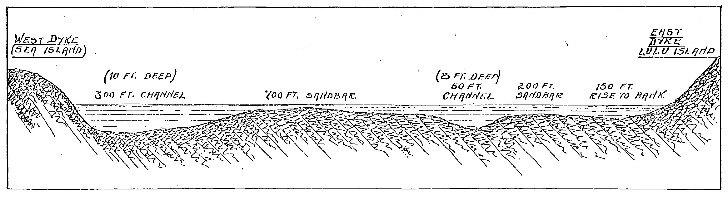 Diagram of the laying of the watermain to Sea Island, 1937. City of Richmond Archives Accession 2011 25
City records such as the 1936 Waterworks Atlas, which mapped all built structures in the municipality and their proximity to connections to watermains, are consulted on a regular basis today by environmental and property researchers studying land use and development in Richmond.
 Waterworks atlas map for area near Alexandra Station, 1936. City of Richmond Archives Map 1991 40 75
In total, the early records of waterworks tell the story of the growth of the municipality through the building of an infrastructure which many people now take for granted.
[Note – this is an updated version of an article first published in the Spring 2015 issue of the Archives News]


You must be logged in to post a comment.